JUDGE EMMETT: KATY PRAIRIE DEVELOPMENT SHOULD STOP ONCE AND FOR ALL  Here’s Harris County Judge Ed Emmett’s declaration Wednesday at a Rice University flooding conference: “We need to completely protect the Katy Prairie. Just set it aside and not touch it.” Or . . . what’s left of it. Last October, he called for a third reservoir in west Houston to “be part of a larger project to create a state or national park for the Katy Prairie.” And he wants Gov. Abbott to tap the state’s “rainy day fund” in order to build the prairie pond. (As for where it would go, a 2015 Harris County Flood Control District study proposed several sites, all on not-yet-developed parcels west of the Grand Pkwy. between Hwy. 290 and FM 529.) [Travis Bubenik] Photo of Matt Cook Wildlife Viewing Area on Warren Lake, south of Hockley: Katy Prairie Conservancy
Sign up for the Newsletter
Tag: Katy Prairie


Local grassland steward the Katy Prairie Conservancy is for the first time branching out beyond its natural habitat with a 5,332-acre ranch about 90 miles outside the area the organization is named for. The Spread Oaks Ranch — part of which is shown above — sits near Hwy. 35 in Markham, just outside Bay City and about 70 miles southwest of Sugar Land. Last December, Spread Oaks’s owner closed a deal with the Conservancy giving the organization’s land trust the power to restrict development and subdivision of the coastal prairie property forever. Spread Oaks still owns the land and can pass it on if it chooses, but the Conservancy gets the power to limit its use, regardless of who has the deed.
Spread Oaks is the name given to the Morrow, Cuenca, and LeTulle ranches — pieced together by a single landowner between 2012 and 2015. The property is a working cattle ranch that “prides itself on raising some of the finest quality Brangus cattle in Texas.” Farming and hunting also take place on the land, which includes lodging for overnight guests. The Colorado River runs along an eastern section of the property.
Before the agreement, all of the roughly 20,000 acres the Conservancy protected were located inside the green ring on the map of west Houston below:
Lending a Ranch Hand

CROSS-COUNTY ACCOUNTING FOR THE HOUSTON FLOODING PUZZLE 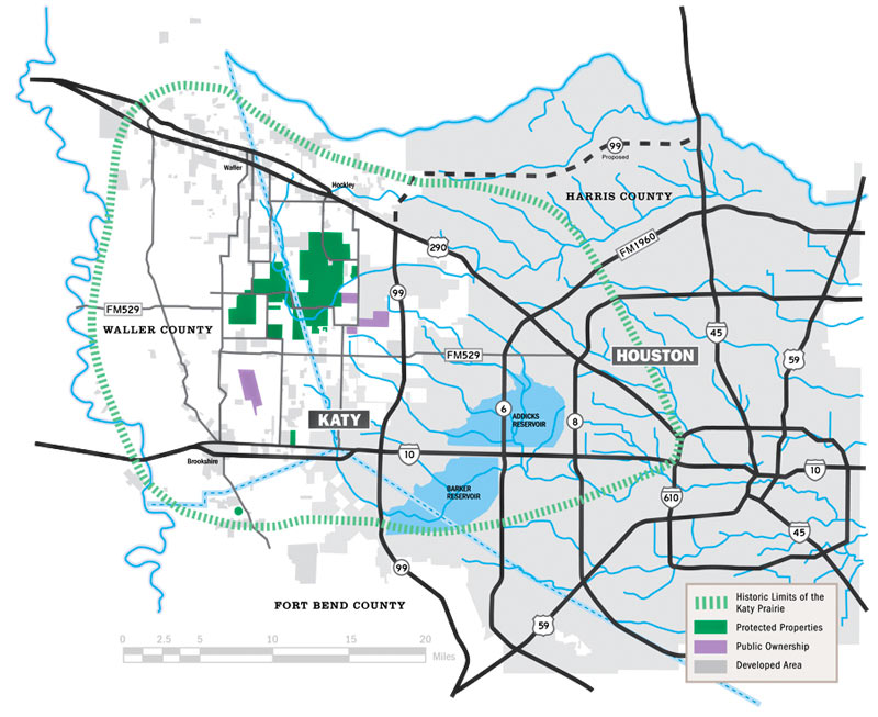 Kim McGuire checks in on the local hardscape in Friday’s Chronicle, as part the latest piece in a series examining roots of the area’s chronic flooding habit. The Houston Area Research Council tells McGuire that roughly 337,000 out of 1.1 million acres of Harris county were covered by surfaces impervious to rainfall runoff as of 2011 (the most recent year of data); meanwhile, softer surrounding counties (including the ones hosting much of the much-reduced Katy Prairie) have been racing to catch up with much higher rates of added hard area. McGuire notes that while developers are generally required to add detention basins to projects that increase the rate of runoff from their land, this does not actually require them to “eliminate runoff from their projects.” Mark Mooney, an engineer for Montgomery County, also tells McGuire that despite the regulatory scrutiny on any individual project with respect to keeping a balance betweeen added runoff and added detention, its still “clear [that] the way water moves through our county has changed. It’s all part of a massive puzzle everyone is trying to sort out.“ [Houston Chronicle; previously on Swamplot] Map of Houston drainage and current/historic Katy Prairie extent: Katy Prairie Conservancy

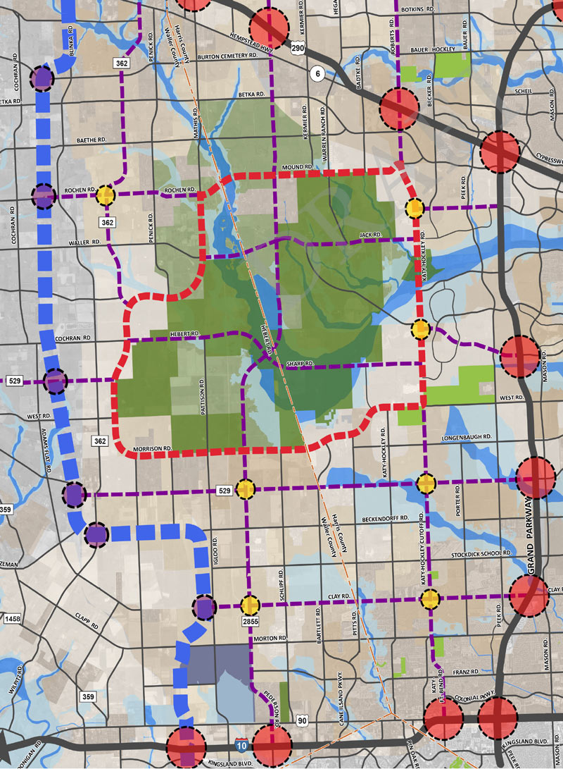
If you missed yesterday’s meeting in Hockley, you have until Wednesday to send Harris County your thoughts on the map above, from the official county study of road network expansion proposed between I-10 and 290 west of the Grand Pkwy. The thick red dashes mark a proposed loop road circling around almost the entirety of the Katy Prairie Conservancy‘s land preserve (shown as the darkest green blocks, amid slightly-grayer-green agricultural/undeveloped land and a few kelly-green public parks). Purple dashes show the proposed routes of new or expanded thoroughfares, some of which cut through the preserve and cross through the Cypress Creek floodway (shown as a blue underlay making a rough U through the conservancy’s land).
Further west (marked in blue dashes) is the not-yet-planned-but-still-showing-up-in-planning-maps route of Houston’s proposed outer-outer-outer loop, SH 36A (formerly nicknamed the Prairie Parkway). The map above also includes overlays of Harris County’s future development predictions, with dark taupe showing existing development and slightly lighter taupe showing expected expansion.
For comparison, here’s the Katy Prairie Conservancy’s map of west Houston; currently developed areas are marked in gray, the organization’s protected areas are marked in green, and the dashed green band shows how far the prairie ecosystem used to extend:
Up the Watershed

A SLIGHT TRAFFIC DELAY ON THE PATH TO BUILDING HOUSTON’S FIFTH RING ROAD 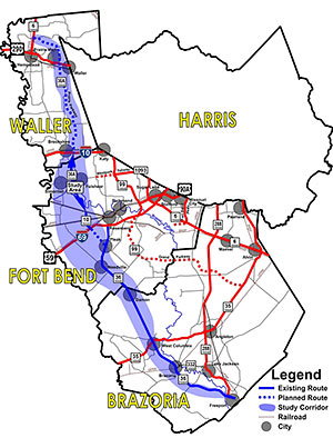 There’s the 610 Loop, Beltway 8, Highway 6 and FM 1960, and the Grand Parkway. What will come next in the grand sequence of giant highways encircling Houston? Why that might be Highway 36A, also dubbed the Prairie Parkway, possibly because the segment of the Grand Parkway opened just a few months ago through similar natural landscape is now already too urbanized to hold onto a prairie-styled name. But the apparent eagerness of Waller County commissioners to have additional tolled segments added to link Highway 36 to State Hwy. 6 (the Waller one, not the West Houston road of the same name) to form what would likely become Houston’s fifth ring-road orbit path hit a slight bump yesterday, possibly because of opposition led by the Katy Prairie Conservancy, whose lands stand in the path. A scheduled vote on a proposed resolution in support of a highway-boosting support group called the Highway 36A Coalition and its request for TxDOT funds to study the proposed 107-mile corridor was withdrawn before it could be discussed, according to a report on Facebook posted by someone who attended the court session. “Instead, a ‘workshop’ has been scheduled for next Wednesday, May 7, immediately after the Court’s regular session,” reads the report. In public comments, according to the attendee, all 11 people who spoke about the proposed highway “seemed skeptical of the project in general.” [Citizens Against the Landfill in Hempstead; previously on Swamplot] Map showing path of proposed Prairie Parkway: Highway 36A Coalition

How long will it take a Katy worker to zoom past acres of newly paved prairie, over a now-uprooted prehistoric burial ground, and under EZ Tag toll sensors on a lunchtime jaunt to the outlet mall in Cypress? Maybe as quickly as 5 minutes, if the 200mph speed reached last week by driver John Hennessey in one of his company’s souped-up Corvettes on the 15-mile stretch of the Grand Parkway between I-10 and Hwy. 290 can be maintained. Of course, that might become a little more difficult once the new Prairie Tollway opens to slower-moving traffic for the first time this coming Saturday.
200mph from Mall to Mall

COMMENT OF THE DAY: ALSO, PAVING OVER THEIR ANCESTORS “Yes we do know what people were doing 10,000 years ago. Basically it’s the same thing we are doing today. Making and raising children, trying to feed our family, and working to have safety, shelter, and clothing.” [Bill, commenting on Grand Parkway Will Pile on the Dead]
GRAND PARKWAY WILL PILE ON THE DEAD  An agreement between TxDOT, the Harris County Historical Commission, and 5 Native American tribes over what to do with the prehistoric human remains unearthed in the prairie highway’s path will allow construction of the Grand Parkway Segment E to continue — with only a bump in the road: “Under the agreement, TxDOT will fill the excavated areas and cover them with rip rap, creating a permanent burial site near where the road would cross Cypress Creek, about three miles south of U.S. 290.” The reburial might confuse future anthropologists, though: “[UH professor of anthropology Kenneth] Brown expressed frustration over TxDOT’s handling of the site, saying crews saved some artifacts but ruined the area for richer study. The agency’s crews scraped and sifted mechanically instead of digging by hand. ‘When you scrape, you will find things, but you won’t be able to see how they were associated,’ Brown said. ‘That is a shame because we do not know what people were doing 10,000 to 14,000 years ago, and we won’t know now.'” [Houston Chronicle; previously on Swamplot] Photo of gravesite: abc13

OLD DEAD PEOPLE BLOCKING PROGRESS OF GRAND PARKWAY  Texas’s department of transportation is requesting permission to remove 4 bone fragments found buried in the Katy Prairie — in the path of what will eventually be the largest-circumference ring road ever constructed around a U.S. city. The bones, believed to represent the remains of several people, are at least 2,000 years old, which would make them older than any human body parts previously discovered in the Harris County area. They were unearthed by construction workers. As a result, construction of a portion of Segment E of the Grand Parkway, which will connect I-10 to U.S. Hwy. 290 through acres of uninhabited grasslands, has been halted. TxDOT’s application asks for “expedited removal” of the remains so that work can continue. [abc13; previously on Swamplot] Photo: Deeya Maple


Tuesday morning, not far from the former grounds of Forbidden Gardens, its now-ransacked replica gravesite of Emperor Qin, and his army of one-third-scale terracotta soldiers at the stub-end of Hwy. 99 and Franz Rd., TxDOT and a contingent of public officials will gather to celebrate the groundbreaking of a notable project for Houston: the paving of a $350 million four-lane toll highway with “intermittent” development-ready access roads across an expanse of largely uninhabited prairie land that stretches between Katy and Cypress. When it’s complete, the 180-mile-long Grand Parkway will be Houston’s fourth ring road, cutting through 7 different counties. But none of the planned segments will forge so dramatic a path through undeveloped land as this particular north-south stretch, called Segment E.

LITTLE GRAND PARKWAY ON THE PRAIRIE NOT SO SHOVEL-READY AFTER ALL Those pesky federal regulators, ruining all the fun: It’s now looking like the 15-mile-long Upper Katy Prairie paving project known as the Grand Parkway Segment E won’t be getting the bucket of cash Harris County Commissioners Court wanted. County officials will instead request that the $181 million in federal stimulus funds earlier allocated to the way-out-northwest loop road be distributed to other projects: “The recommendation to withdraw the project from the Texas Department of Transportation’s list of stimulus projects was made by Art Storey, who heads Harris County’s Public Infrastructure Department. Storey declined to comment on his recommendation until it is considered at Harris County Commissioner Court’s meeting next Tuesday. ‘Staff and consultants have worked diligently and successfully to be on schedule to meet the deadlines to enable Segment E construction to qualify for and receive the stimulus funding, but the federal permit from the U.S. Army Corps of Engineers cannot be completely processed by the required mid-February date,’ Storey said in a letter to the court. ‘In fact, because of conflicts over environmental impacts and mitigation, that permit might never be issued.’” [Houston Chronicle; previously on Swamplot]
COMMENT OF THE DAY: HOUSTON’S ROOM TO SPREAD OUT “. . . We by far are not paving our wilderness in concrete. The Katy Prairie represents and extremely small portion of area getting developed. The land you see in the Katy Prairie exists throughout south central Louisiana were it’ll likely never be developed. The Texas Coastal plains is quite undeveloped also. All this crying over really nothing. Wildlife is quite more adaptable than we give them credit for and they’ll move easily where they have to. I’m more and more convinced that people that live in Houston that go after developers for building the outer suburbs don’t realized how much is not developed when they leave the city. I guess they fly everywhere versus drive. The drive from Houston to Dallas alone should demonstrate how uninhabited this state is. Better yet, drive US 59 in either direction from Houston.” [kjb434, commenting on Investing in the Grand Parkway]
BRIDGELAND OVER THE FLOODWATERS Last week’s flooding in northwest Harris County provided only a taste of the problems likely to stem from development in the Katy Prairie along segment E of the planned Grand Parkway, say supporters of a Sierra Club challenge to existing floodplain maps in the Cypress Creek watershed. “An executive of Bridgeland GP, the company developing the 11,400-acre community, said in a Jan. 9, 2008, affidavit that the revisions sought by the Sierra Club would cost the company $28 million in flood mitigation measures that would ‘adversely affect’ the development. Despite the company’s efforts, the maps are being redrawn under U.S. District Judge Lee H. Rosenthal’s supervision. Rosenthal has stayed the lawsuit until October to allow time to complete the maps, but officials said they aren’t certain when the task will be finished. Preliminary revised maps [(PDF)] shown to the Houston Chronicle by [Sierra Club attorney Jim] Blackburn and the Harris County Flood Control District show a significant expansion of the flood plain in an undeveloped western segment of Bridgeland’s property and a reduction of the flood plain in other areas. . . . Asked if Bridgeland could assure Harris County residents that its development won’t worsen future flooding downstream, [Bridgeland VP of Sales] Houghton said, ‘I would have no problem guaranteeing that.'” [Houston Chronicle]
GRAND PARKWAY SPRAWL STIMULUS “The road exemplifies an unintended effect of the stimulus law: an administration that opposes suburban sprawl is giving money to states for projects that are almost certain to exacerbate it. A new master-planned community called Bridgeland is rising on the prairie along the proposed site of the road; once completed, the development is expected to have 21,000 new homes on 11,400 acres. Other developers are eagerly awaiting the new road so they can start building on their empty land, too. . . . [Roger H. Hord, the president of the West Houston Association] pointed out that the road would connect two existing highways and said it would ease congestion on some of Houston’s other beltways. He said that an existing leg of the Grand Parkway, just to the south of the proposed leg, would give a sense of what the new stretch of the Grand Parkway might look like when it is done. The existing stretch is lined with strip malls and gas stations and drug stores and a huge 7,600-acre residential development called Cinco Ranch that is popular with families.” [New York Times]
MOVING THE KATY PRAIRIE, ONE CLUMP AT A TIME Threatened patch of prairie? Shovels to the rescue! “The 90-acre patch at Saums and Greenhouse roads north of I-10 is a subtly spectacular example of what the dwindling Katy Prairie looked like before development spread west out of Harris County. Sometime later this fall, construction on the extension of Greenhouse Road, plus a detention pond, will start there. Folks in straw hats, with shovels, buckets and bug spray, spent several mornings digging up clumps of this mature prairie for transplanting to other sites. . . . Digging up clumps of little blue stem, rattlesnake master and bee blossom gives prairie gardens a jump start they couldn’t get from seeds – and seeds are hard to come by.” [Inside Fort Bend]