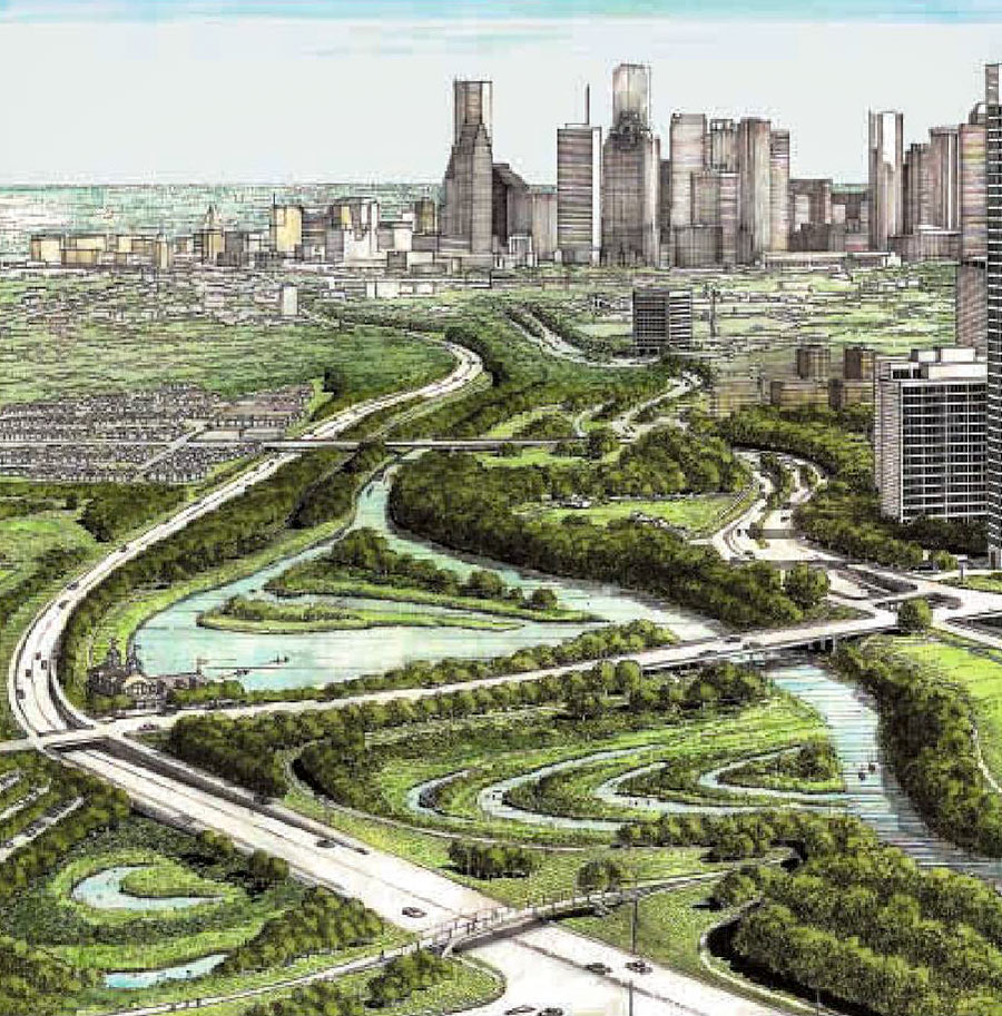
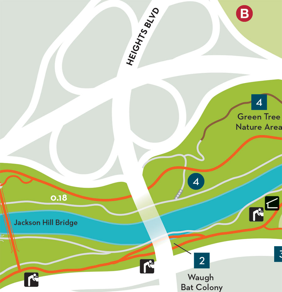
Here’s another highlight from the city council’s meeting this morning: Plans to get rid of the cloverleaf interchange that moves traffic between Waugh Dr. and Memorial Dr. got the green-light and will be sent over to the Houston Galveston Area Council as part of an application for funding. The idea first emerged in the Buffalo Bayou Partnership’s 2002 Master Plan as a way to make room for more bayou-side park space at the crossroads. Right now, all the land adjacent to the ramps — shaded gray in the map above — is vacant, except for the portions lassoed by the circular roadways, where 4 isolated tree groves continue to undergo seasonal color changes. You can see they’re gone in the east-facing rendering at top included in the Partnership’s plan — replaced by inlets, islands, stormwater detention, and what looks to be a boathouse at the southeast corner of the 2 roads — all accessible from a network of new walkways that link up to existing bayou-adjacent trails.
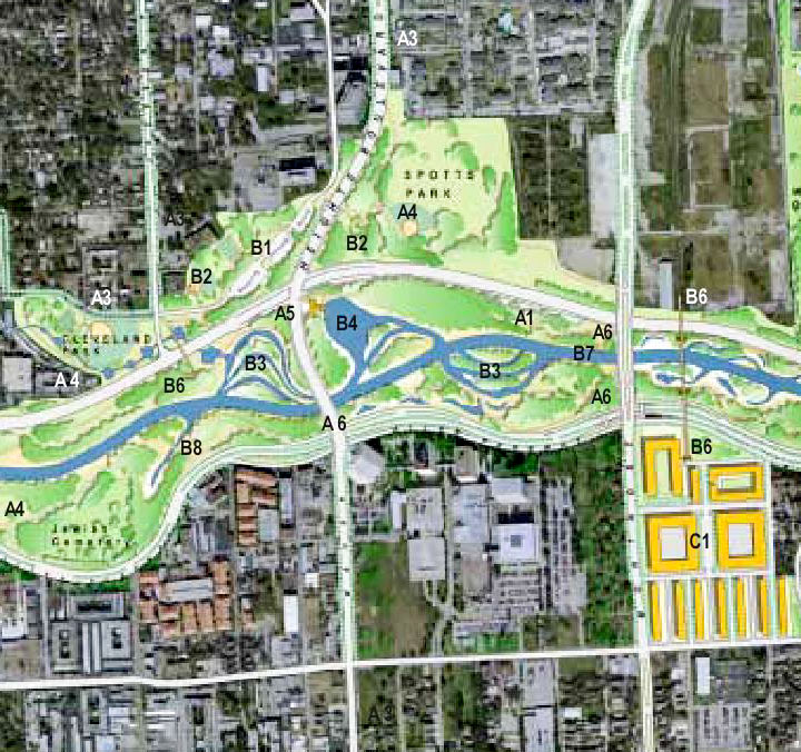
In total, 16 new acres are expected to become part of the park — providing a continuous swath of green between Spotts Park and Cleveland Park, shown below on opposite sides of Waugh in a map from the 2002 plan:
***
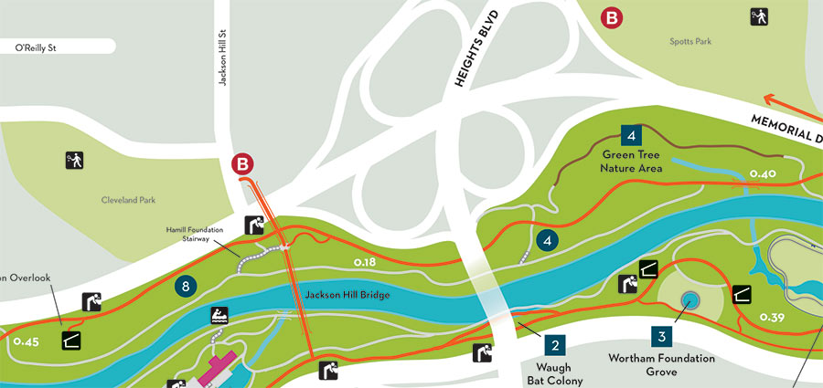
A broader look at what’s there now:
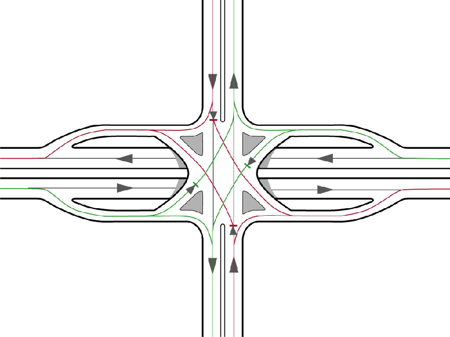
As for the drivers who’ll still need an interchange: They’ll get one that’s something like what this diagram depicts. Formally known as a Single Point Urban Interchange, the design takes up less space than the existing loops and would allow all cars (shown in green) making left and right turns off Memorial to get onto Waugh at the same time as one another. Likewise, everybody (red) gunning for Memorial from Waugh could do so simultaneously, too. The catch: Traffic lights are what make the whole thing work.


looks good. wish it was done yesterday tho.
Well I’m confused. This sounds like increased travel times and pollution for waugh/memorial connections and a whole lot of money being spent to claim what will ultimately be underutilized park space.
.
You could spend a fraction of the same amount of money and get way more than 16 acres of green space elsewhere in Houston. Not to mention in far far far more needed areas.
.
Must be nice having money burning a hole in your pocket that has to be spent.
Good for the park (I suppose – seems like “inlets, islands, stormwater detention” are unused space just as much as the current iteration is). Terrible news for Montrose residents trying to get to Memorial Park/I-10/downtown and Heights commuters trying to get downtown. Also, this intersection design combined with Houston drivers seems like a disaster waiting to happen #savethecloverleaf
They better add a decent bike lane to that too. It’s ridiculous that that bridge is currently designated as a bike path.
Terrible spot for a traffic light.
Before this massive project, how about fixing that gigantic sinkhole at the end of the field? For the record, although I’m generally a proponent of additional greenspace, I don’t think it’s needed here and believe the introduction of traffic signals will be more problematic that this project will be worth.
if this keeps Memorial Drive from flooding, it will be worth the extra traffic burden that a light will create. Once the HEB opens and the rest of the old apartment complex is redeveloped, Waugh Ave will be choked with traffic and an extra light at Memorial may actually help space things out. Right now, people let it rip going over the bayou and crash their cars into people turning out of the apartments or Spotts park. A slower and more orderly Waugh Ave would be nice. The only real downside is that the Cloverleaf was a prime spot for running on hills for those who were training for the Boston marathon.
Good point old school. Going from east bound on memorial to northbound on Waugh via the clover leaf is rather dangerous.
While I wish it was something a bit more innovation, like a roundabout?!?, a stoplight will make things safer and more orderly.
lol at the comments that this will be “underutilized park space.” The Buffalo Bayou Park as been a huge hit since its makeover and has generated a flurry of development activity and increased land values in the area. Look at recent land purchases by Hines and Hanover for highrises nearby. As the broker for one of those purchases commented, “This is Houston’s beachfront property.”
The cloverleaf has caused death and serious injury for cyclists. Drivers in this area are induced to drive way too fast on what should be treated as a city street, not a freeway. I will be happy to see it go.
Cloverleaf interchanges are one of the worst kind of intersections for having flowable traffic. The phase out into the drawn plan above is likely able to handle similar levels of congestion and movement as the cloverleaf. I dont agree with commentators stating this will increase congestion. On the contrary, I think this would improve it. Less lane changing by cars to get to their destination. Less deceleration required by cars transitioning from one motorway to the other. The only merge is on Memorial, as opposed to now wherein theres merges on Heights and on Memorial. The one on Heights barely has an acceleration lane.
@Mike, well understood on the value of surrounding land, but that has always been the case both before and after all the modifications. Even now there’s vast sections of this park that remain empty on a near daily basis.
.
I’m just trying to understand what the true justification is for the expense, which will be significant. Additional park space is needed in far more appropriate areas. I’d agree with the others that this section of Waugh is crazy dangerous during rush hours so I could understand if the intent is to slow traffic, but that can be fixed with much more minor expense.
.
This sounds like the type of proposal you make when you have to waste the money in your bucket or risk giving it up to someone else.
Not a fan of removing the clover leafs. This is put traffic at a stand-still on Waugh.
I’m not a hydrogeologist nor a resident of the area. However, it does seem attractive to make more of the land there accessible to people – community needs have changed since the cloverleaf was designed, which seemed to be tailored more to making the scenery more attractive to motorists traveling to and from downtown.
That said, I hope the planners use a competent hydrogeologist (or other relevant professional) to play a part in the design, in terms of the flood-control aspect. My comment is motivated by a concern that someone might have sketched this plan without really knowing much about mitigation of flooding. I have an earth-science background, but this is not my field. However, I have to wonder whether how effective the cute side-channels would be in mitigating flooding.
That looks like a royal cluster F*** waiting to happen…
There are traffic lights on Waugh a baby step from each side of this, and Memorial continues to be unimpeded. The actual net effect is going to be taking out a couple more Merges Of Death, which will make driving less fun (for those of us who are native Houston drivers who venerate Our Blessed Lady of Acceleration). Sad.
How is this going to work with the Memorial E > Waugh S off-ramp? Traffic already backs up onto Memorial, even with the off-ramp’s current, winding path.
What about the bats?
When I scanned quickly and saw “Extra Park Space”, I kind of got excited because there is not enough parking as it is for all who want to enjoy Houston’s version of ‘Central Park’ in the swamp! I live close by, and I always see people on weekends driving slowly trying to find parking. I can’t for the life of me figure out why there are no parking garages for the sole purpose of enjoying the park.
.
So, when I read the article, it meant Park as in green Park. No extra car parking. Could they not include that in their plans too? Maybe I missed it… I did not click on any links, and don’t see a parking garage sign on the drawings.
.
One other point, about the exchanges… there are other UPS stores closer to me, but I specifically chose the one on 5535 Memorial because I like the drive going north on Taft, taking a left on Allen Parkway and using that clover leaf to get onto Memorial and to the UPS store… likewise, on the way back, I get on Memorial, take a right on Shepherd and a left on Allen Parkway back up Taft. Beautiful drive to the UPS store that I enjoy, and very fast actually… plus, I always get a Starbucks coffee since it is next to the UPS store. The stoplights on Waugh will, well, XXXX that up big time for me… I will have to find another UPS store. Who could have thought of those consequences?!
Leave it as it is! The current crepe myrtle groves are beautiful. And, this fiasco will snarl traffic and Buffalo Bayou hike & bike traffic for YEARS. Why not focus on fixing the Harvey damage to the current trail, connecting the downtown trails together, and finishing the connection between the Stude Park and Heights trails?
I live about 1/2 a mile from this. Looks great to me. I don’t know how it will affect traffic but I really don’t care. The great thing about living in North Montrose is that you don’t have to worry much about traffic. The area is dense enough that you just don’t have to drive much. It’s the people coming in from Katy, etc… that deal with trafffic. When I lived further out and had to commute I rode metro, that’s what people from the burbs that work downtown or in the galleria should do… problem solved. I did it every day for years, it’s actually very nice riding in on the bus.
As planned, this will be a traffic nightmare. However if they added a four lane camel back for Waugh traffic above the intersection (similar to the concept Shepherd/Memorial intersection) this could work rather well.
Kind of taken aback by some of these comments!
The cloverleaf is between 3 existing parks and will allow all of them to be linked together! Being a biker or pedestrian and trying to get through the Waugh cloverleaf is so laughable dangerous.
And traffic to a standstill? You mean, after the other light that’s 300 feet away?
Drivers are driving way too fast on Waugh and this will hopefully slow them some as well.
Would love for them to integrate some type of additional pedestrian/bike infrastructure with the redesign as well.
I’m sure the traffic analysis for the Waugh HEB shows increased congestion at Washington & Waugh, but it’s not like the people who frequent that store aren’t buying groceries today, they’re just doing it further away.
I, for one, will be crossing the bayou much less frequently once the HEB on Shepherd opens.
ITT: people who aren’t traffic engineers, who don’t understand that SPUIs are usually free-flowing during non-peak times, since the only movement with a red is a left turn off Memorial – Waugh/Heights will be green, and a right off Memorial has a dedicated ramp.
.
They also handle flow much better than a cloverleaf during peak times, since the loop ramps don’t get backed up from having to compete with through traffic. You also don’t have the weaving problems (loop onramp vs loop offramp) that you do with cloverleafs.
Something tells me this will get redone more time than the Johnny Steele dog park.
I live in the apartments just north of Spotts Park, where the cloverleaf ramps merge with Heights Blvd and these improvements are greatly needed – especially a stop light. Traffic coming across this bridge is usually going 20+ mph over the speed limit and makes for an especially dangerous situation at Willia-Feagan Street intersection.
One several occasions I’ve witness pedestrians nearly get wiped out by drivers coming through this intersection. The worst was a family of three, pushing a stroller, that had to back peddle when a car doing 50 off the cloverleaf ramp came blowing through. Turning into or out of Willia Street is an exercise in patience and luck in cheating death.
Seriously one of the worst / most dangerous intersections in town right now.
First of all there won’t that much more traffic; second adding more street lights WILL cause MORE congestion. Who are the idiots that “plan” these “improvements”? Let’s see: the architects, builders, contractors, designers, engineers who ALL have deep pockets & conflicting vested interests ( aka $$$$ ) riding on this boondoggle. In true Houston fashion, construction will start during hurricane season and take 8.7 years to be completed. What a waste of $$$, time & resources. Build it elsewhere. Because the next Harvey will flush the whole thing into Galveston Bay !!!
It seems like a city project that prioritizes pedestrian/cyclist/walkers over drivers. bring it on. The opportunities are so limited to expand greenspace inside the city, so I’m glad they are pursuing this.
What happens to that huge ancient tree near the bat bridge? In the images it looks like it is under water.
TMR: the Partnership has done a pretty terrible job of giving specifics about how this would work. Congrats for being a traffic engineer, but public works need public approval, and it’s incumbent on those who want to undertake public works to properly explain them to the public, including the pros and cons of proposed change as compared with the current design. Condescension towards the people who are going to pay for the public works is counter-productive.
To hell with traffic flow. I’ll miss draggin’ a knee!
I’m certain this initiative is to alleviate downtown flooding.
Around the Wortham it’s constant bayou maintenance…
Car traffic is not on the radar.
Thank you J!!
Way to go—spending a lot of money to “fix†something that isn’t broken while actually making the quality of life worse for the vast majority of Houstonians!
Remove the freeway configuration of Memorial Drive from Shepherd to downtown. An urban street is all that is needed here since this mid-century design was prior to I-10 and was the original route for Katy bound suburbanites. The Bayou is now THE destination – not a place to flee at break-neck speeds. Besides, the freeway configuration is useless as it ends prior to Memorial Park. The configuration has exceeded its useful life and is actually in very poor condition. Reasonable thought to an improved alternative is preferred and hopefully includes more park space.
Will there be a away to get a bike trail from White oak to this area? Right now cycling down Waugh south of I-10 is a death trap.
@Heightsi: Believe there are plan (or that plans are being developed) to get a bike path down Patterson from White Oak to Buffalo Bayou.
@El Chico: The freeway design is amazing on Memorial for access into downtown and I-45 South (for now at least, the proposed I-45 reroute will change this though). Your urban street for this area is Allen Parkway.
Looking at the designs, it doesn’t look the Park is getting much out of the redesign, but there should be a slight increase to Buffalo Bayous out of banks volume before hitting Memorial Drive (the the underpass here and at Shepherd will still flood).
This isn’t necessary. Traffic flows now and stop lights will only create congestion. This park already goes from downtown to Memorial Park. An additional 16 acres is insignificant and will destroy the beautiful groves of crepe myrtles. A total waste of taxpayer money.