COMMENT OF THE DAY: WHY THE ROADS DON’T GO THROUGH  “. . . Easy — Look at the intersection of Gessner & West Rd. Gessner is blocked to the north by a subdivision, West Rd. is blocked to the east by a landfill (or sand mine or whatever that site is; hard to tell from the aerial). Both roads could connect through, but development blocked ’em.
Having been involved in a couple of these scenarios, I’ll tell you how they typically happen: Developer meets with the city after submitting a plat. City says something like ‘connect the roads or we’re not going to approve your plat and you’ll never get to build it.’ Developer says something like ‘that will result in reduced usability of my site and increased cost to develop it, so if the City wants the road to connect then the City needs to pay $X million.’ City counters with ‘we’re not going to pay for anything, but if you don’t build the road we’re going use eminent domain to take the land and build the road anyway.’ Developer finishes them off with “Well then you can either a) give me $X million and I’ll build the road, b) or I’ll donate enough $ to the council member and mayor races to get what I want.’ The city settles for c) Do nothing, back down, and don’t get the road — because otherwise the staff member who stood up to the developer in the first place would get canned.
I’m not saying that’s how they all happen, but that’s how the couple I’ve been involved in went.” [Ornlu, commenting on Comment of the Day: The Missing Links] Illustration: Lulu
“. . . Easy — Look at the intersection of Gessner & West Rd. Gessner is blocked to the north by a subdivision, West Rd. is blocked to the east by a landfill (or sand mine or whatever that site is; hard to tell from the aerial). Both roads could connect through, but development blocked ’em.
Having been involved in a couple of these scenarios, I’ll tell you how they typically happen: Developer meets with the city after submitting a plat. City says something like ‘connect the roads or we’re not going to approve your plat and you’ll never get to build it.’ Developer says something like ‘that will result in reduced usability of my site and increased cost to develop it, so if the City wants the road to connect then the City needs to pay $X million.’ City counters with ‘we’re not going to pay for anything, but if you don’t build the road we’re going use eminent domain to take the land and build the road anyway.’ Developer finishes them off with “Well then you can either a) give me $X million and I’ll build the road, b) or I’ll donate enough $ to the council member and mayor races to get what I want.’ The city settles for c) Do nothing, back down, and don’t get the road — because otherwise the staff member who stood up to the developer in the first place would get canned.
I’m not saying that’s how they all happen, but that’s how the couple I’ve been involved in went.” [Ornlu, commenting on Comment of the Day: The Missing Links] Illustration: Lulu
Sign up for the Newsletter
Tag: Streets

COMMENT OF THE DAY: WHERE’S OUR MEMORIAL PARK BYPASS?  “This ramp will now allow more traffic to use Shepherd as an alternate to the freeway system. Thus creating longer delays for those who use surface roads to travel. What is sorely required is a road that would flyover Memorial Park adding a much needed way to travel from the inner loop north. Currently, the only options are the West Loop and Kirby/Shepherd. Both of which are overly congested at most times of the day. It doesn’t help that Shepherd is down to two lanes from four in stretch from Westheimer to Dallas while the city installs much needed storm drainage.” [jgbiggs, commenting on Your Upgrade from Shepherd Dr. to the North Fwy. Will Be Much Smoother Starting Today] Illustration: Lulu

SAVING UPTOWN, HOUSTON’S MASTERPIECE, FROM THE SCOURGE OF DEDICATED BUS LANES 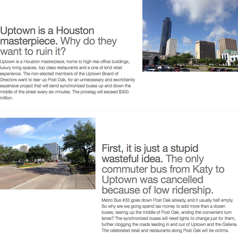 The Uptown Property and Business Owners Coalition is out today with a new website (portrayed here) meant to drum up opposition to the Uptown District and Metro’s plans to install dedicated bus lanes down Post Oak Blvd. The lanes, the last vestige of what was once a plan for an Uptown light rail line, would run from dedicated bus lanes linking to the Northwest Transit Center all the way to the proposed Bellaire/Uptown Transit Center near U.S. 59 and Westpark, where they might someday intersect with a University Line traveling eastward from that point. But the team behind the website wants none of it: “Uptown is a Houston masterpiece. Why do they want to ruin it?” reads the copy on the home page. Meanwhile, an introductory blog post on the site encourages readers to attend a friendly “town hall” meeting, tomorrow night at the Uptown Hilton, in the company of “hundreds of angry business owners and Uptown area residents.” [Save Uptown; previously on Swamplot]

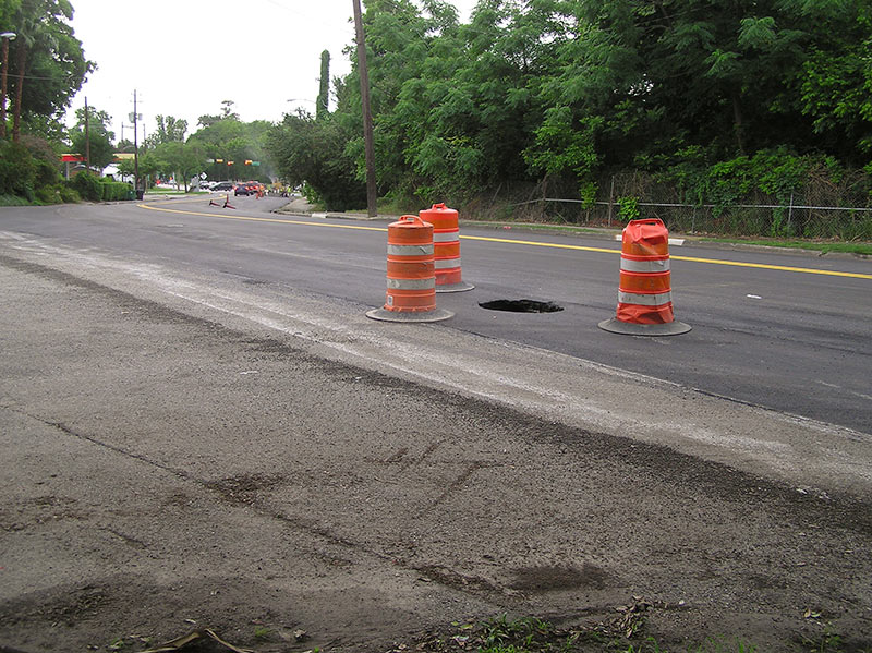
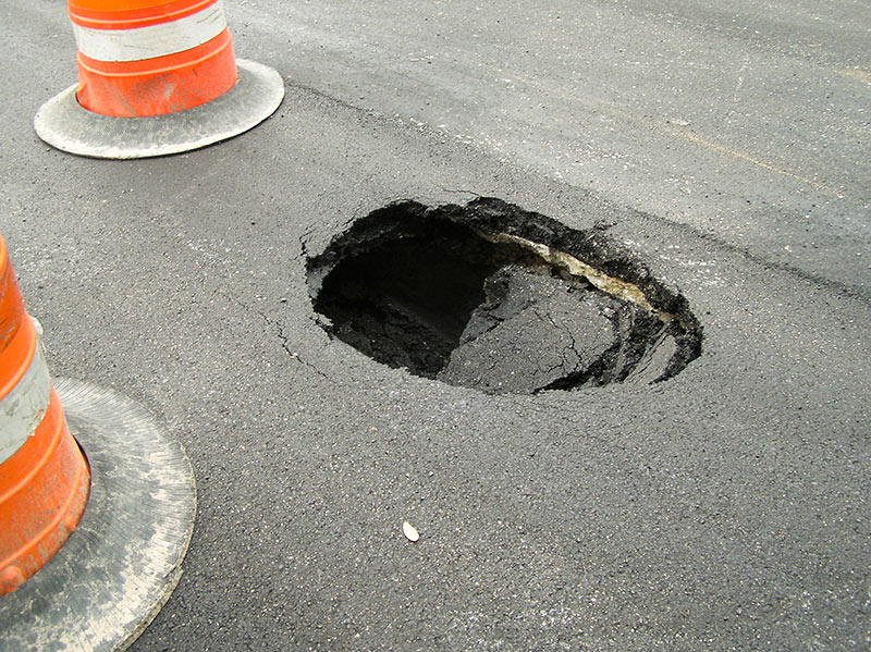
Heavy equipment is back on the scene — and a metal plate on the way, a reader tells us — at the corner of White Oak Dr. and Beauchamp in Woodland Heights, adjacent to White Oak Bayou, where a hole suddenly appeared in freshly spread asphalt just hours after the street was resurfaced yesterday.
That Sinking Feeling

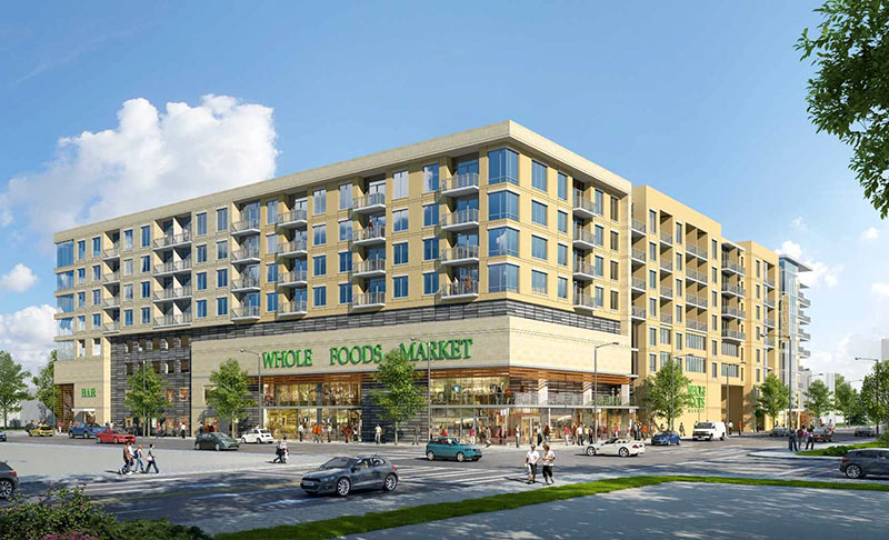
Now we know why the Morgan Group, the developer that applied for a variance last year to allow for a Pearl on Smith apartment complex to fit onto the block surrounded by Elgin, Smith, Brazos, and Rosalie streets, later withdrew the request: To expand the project so that it could include a 40,000-sq.-ft. Whole Foods Market on its ground floor. And here’s a rendering of the design of the whole thing by Houston’s Ziegler Cooper Architects.
Pearl on Smith on Elgin

ONE WAY TO GET RID OF THAT PESKY TRAFFIC: TAKE AWAY THE STREETS 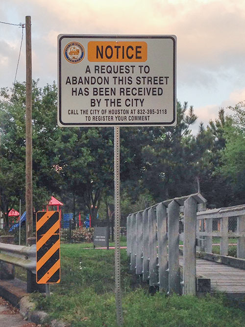 Signs are up around the Memorial City Apartments at 872 Bettina Ln., immediately south of the Memorial City Mall and adjacent to Frostwood, announcing a request that the city abandon portions of Bettina Ct., Strey Ln., and Kimberley Ln. (where the above photo was taken). The request was submitted by the limited partnership that owns the apartments. Its purpose, according to the city’s public works department, is “to reduce the amount of cut-through traffic in the neighborhood.” If granted, the complex would grant the city utility easements over the existing right-of-way. There’s more to it, according to the public works department: “Right-of-way will also be conveyed back to the City for a cul-de-sac to be constructed at the new terminus of Kimberley Lane, which will provide a connection to the driveway in to Bunker Hill Elementary. The cul-de-sac will also contain a 911 emergency gate to allow emergency vehicles to access the apartment complex from Kimberley Lane. Access to Bettina Court and Strey Lane will remain open from Barryknoll Lane, but any traffic turning on to these streets after the abandonment will only be able to access the apartment complex. Signs notifying the public of the subject request were posted April 3, 2015 and will remain up for 30 days.” So is everyone on board with this? So far, only 9 calls have been made to the city in response to the signs, with just one objecting to the deal. Photo: Swamplot inbox

COMMENT OF THE DAY: THE SIGHTS OF MONTROSE 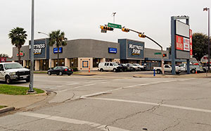 “Look at those pictures! The cityscape in Houston is so beautiful that I sometimes want to cry. I love the setbacks, the crumbling streets, the large signs, the little bit of grass, and oh man oh man those two lonely palm trees. This is the part the Houston that I want to show off to my friends. After a nice dinner at Uchi, I love to take everyone on a stroll around my beautiful city!” [Duston, commenting on What’s Arriving Now at the Sleepy Corner of Westheimer and Montrose]

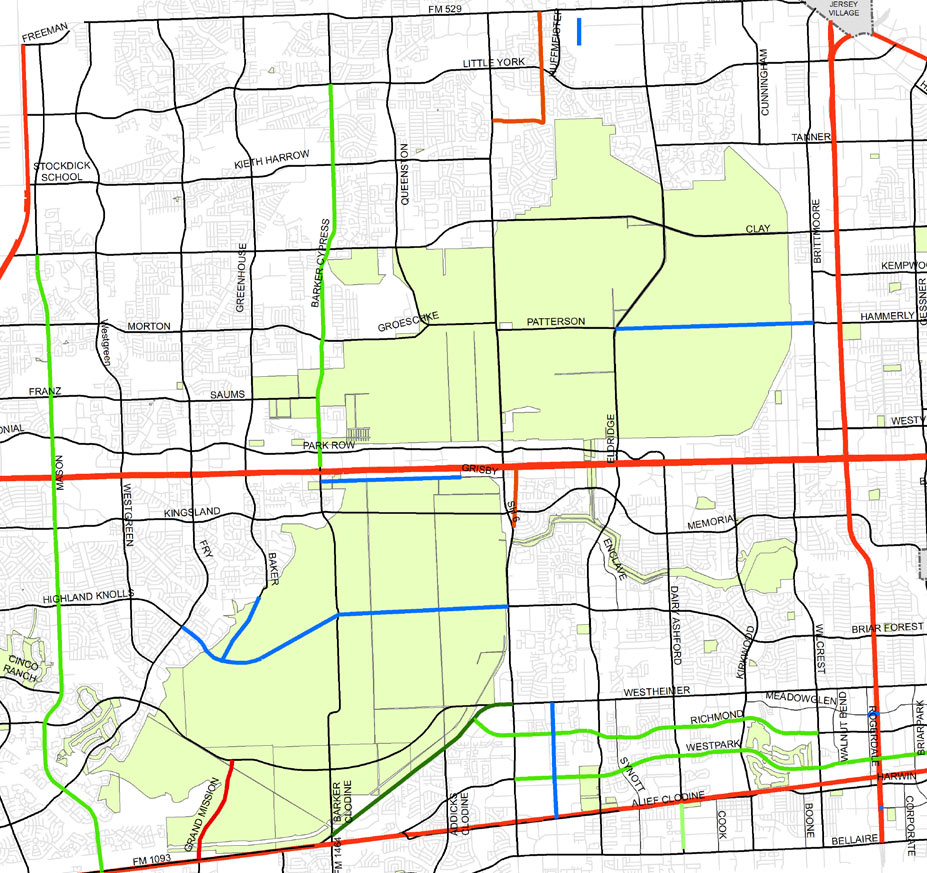
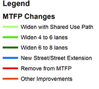 There’s a rather bold new plan for 2 of the Houston area’s major parkland reserves hiding in an image included in an almost-final draft of the West Houston Mobility Plan being prepared by the Houston-Galveston Area Council for submission to TxDOT. A new roadway connecting Briar Forest Dr. to Highland Knolls Dr. through the heart of 7,800-acre George Bush Park is shown in a proposed major-thoroughfare plan for the area. (See segments in blue in image above.) A segment of Baker Rd. is also shown linking to the new parkway. And north of I-10, a similar major roadway is seen connecting Hammerly Rd. to Patterson Rd. — through the Addicks Reservoir.
Connecting Briar Forest Dr. to Highland Knolls

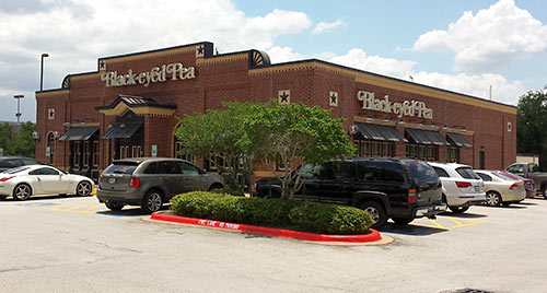
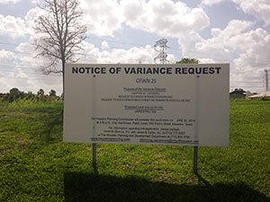 Here’s the variance sign (at right) that went up over the weekend at the intersection of Gramercy St. and Kilmarnock Dr., backing up to the power-line easement and ditch that separates the city of Bellaire (beyond the sign) from Houston. Supra Color Enterprises, the Florida-based landlord of the Black-eyed Pea restaurant at 4211 Bellaire Blvd. (above), is requesting a variance from the city as part of an effort to redefine its 1.8-acre property at that address as an “unrestricted reserve.” The variance application doesn’t reveal Supra Color’s plans for the land, but it does refer to a “proposed multifamily development” on the site.
Development Rumors and Mashed Peas

COMMENT OF THE DAY: WHY THERE’S SO LITTLE TRAFFIC DOWNTOWN  “Downtown traffic is some of the easiest traffic of any US city downtown I have ever been to, and actually some of the best traffic in all of Houston. Why? As near as I can tell, it’s because: (1) street parking is virtually not allowed or limited to one side of the street, which prevents people from aimlessly circling around looking for that one free spot; and (2) one-way streets. People complain about one-way streets as confusing but when there is a good grid like downtown or midtown, they work perfectly. I can’t ever recall sitting through more than one cycle of a light in midtown. There are other areas of Houston where this can easily be done. And ban street parking completely on major roads after 4pm. It’s just valets making money off blocking traffic after a certain hour.” [John Chouinard, commenting on Comment of the Day: A Few Remedies for Those Traffic Problems You’ve Been Having] Illustration: Lulu

COMMENT OF THE DAY: A FEW REMEDIES FOR THOSE TRAFFIC PROBLEMS YOU’VE BEEN HAVING 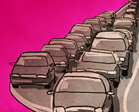 “Number one. Eliminate dead ends inside the loop. Every neighborhood in Houston has blocked off 99% of its streets. There are times when I need to wait multiple cycles at a light because it’s the only ingress into the development. Houston is a CITY.
Number two. Learn how to merge. There is construction at Mid Lane at San Felipe eastbound, and traffic is backed up to 610 because everyone is terrified of being in the barren empty right lane, which in turn is because they know people will be hostile to allowing them to merge. This is the single most stupid driving behavior I can think of. You need to queue AT the point of the merge, and alternate left and right lanes, quickly, cleanly, efficiently and politely. A whole mile of road empty? Come on people.
Number three. Get out of the way of people behind you who want to be in the left-turn lane. Many of those turnlanes have sensors, and will not give a left arrow if no cars are at the line — AT THE LINE — when the other side’s light turns red. Or yellow! There are multiple examples of lights where you don’t get an arrow unless you beat the other side’s yellow. So every time I see a driver with two empty car lengths in front of them, and a driver with their left-turn signal behind them, I just wonder. (The reason I stressed ‘at the line’ above is that I was once behind someone who was a car’s length away from the line. I asked myself, should I honk or shouldn’t I? I wasn’t sure about this light, so I bit my lip. You can guess the rest).
Number four. Make all streets one-way. Every single one. Even Westheimer. In residential neighborhoods you can only get one car through anyway, because everyone is parked on both sides. Just get it over with already. The left and right turns will also be that much easier.” [J.V., commenting on Comment of the Day: We Have Met the Traffic, and It Is Us] Illustration: Lulu
“Number one. Eliminate dead ends inside the loop. Every neighborhood in Houston has blocked off 99% of its streets. There are times when I need to wait multiple cycles at a light because it’s the only ingress into the development. Houston is a CITY.
Number two. Learn how to merge. There is construction at Mid Lane at San Felipe eastbound, and traffic is backed up to 610 because everyone is terrified of being in the barren empty right lane, which in turn is because they know people will be hostile to allowing them to merge. This is the single most stupid driving behavior I can think of. You need to queue AT the point of the merge, and alternate left and right lanes, quickly, cleanly, efficiently and politely. A whole mile of road empty? Come on people.
Number three. Get out of the way of people behind you who want to be in the left-turn lane. Many of those turnlanes have sensors, and will not give a left arrow if no cars are at the line — AT THE LINE — when the other side’s light turns red. Or yellow! There are multiple examples of lights where you don’t get an arrow unless you beat the other side’s yellow. So every time I see a driver with two empty car lengths in front of them, and a driver with their left-turn signal behind them, I just wonder. (The reason I stressed ‘at the line’ above is that I was once behind someone who was a car’s length away from the line. I asked myself, should I honk or shouldn’t I? I wasn’t sure about this light, so I bit my lip. You can guess the rest).
Number four. Make all streets one-way. Every single one. Even Westheimer. In residential neighborhoods you can only get one car through anyway, because everyone is parked on both sides. Just get it over with already. The left and right turns will also be that much easier.” [J.V., commenting on Comment of the Day: We Have Met the Traffic, and It Is Us] Illustration: Lulu

THE APARTMENTS THAT WANT EXXONMOBIL PASSAGE  Here’s a rendering of the complex Alliance Residential has just started building north of the ExxonMobil campus. The 3-story, 341-unit building will be located on 1615 Sawdust Rd. — which the developer appears to hope might be used as a kind of driveway for that big new campus in the pines to the southeast: “Alliance said there are plans to extend Sawdust, which will provide an avenue leading directly to the . . . campus without getting on Interstate 45,” reports the Houston Business Journal. “However, this portion of the project is still in the planning stage and is waiting for funding from the city.” Alliance is also building the midrise Broadstone 3800 complex at the corner of Alabama and Main. [Houston Business Journal; previously on Swamplot] Rendering: Alliance Residential Co.


That no-tracks land along Harrisburg Blvd. between 66th and Cowling on the East End Line is supposed to look something like the underpass that these new renderings depict. Right now, though, Harrisburg isn’t passing under anything — but lying in wait instead between the nearly completed eastern and western sections of the line that stop here dead in their tracks. Though Mayor Parker announced more than 2 years ago that the East End Line would get $20.6 million in diverted funds to build the Hughes Underpass below the Union Pacific East Belt freight rail line, construction hasn’t started. Why? Well, it appears that Metro hasn’t selected a company yet.

")
There are almost 6,000 miles of street in Houston, according to the Memorial Examiner, and now about a half a mile of one in Midtown can call itself remarkable. The Greenroads Foundation, which confers on streets a kind of LEED-like designation, gave its first formal props to a project in Texas to Bagby St. between Tuam and St. Joseph Pkwy., for the $9 million in improvements built along the 0.62-mile span the past few months.
Included in those improvements are bike racks, street furniture, wayfinding signs, wider sidewalks, and narrower, less harrowing crosswalks. (You can see in the photo above that these improvements don’t include burying utilities.) But the designation isn’t meant just to make the lives of pedestrians more aesthetically pleasing: LED lights were installed; rain gardens were put in to help with drainage; “fly ash” concrete, which reduces carbon emissions, was used where possible; and Bagby itself, with its potholes, patches, and cracks, was repaved atop what the Midtown Redevelopment Authority calls “newly stabilized materials” that are supposed to require less maintenance over the long haul.
Here are a few more looks at the transformation:
 and Improved... "Pin It")
COMMENT OF THE DAY: ALL THAT FRACKING TRAFFIC  “The gear needed to frac wells on a single well-pad is unbelievably heavy. A single pump might weigh 75,000 lbs, and you use 12 or more on a single pad, not to mention a hydration unit, a blender, a manifold, a data van — and these are the things that just stay on the well site. You also have sand carried in vehicles so big that they are often called ‘sand hulks’. They come and go from a single well site constantly. And depending on how you get water to the site, that may mean even more trucks.
This army of vehicles leaves from a single yard and tends to go over some of the same roads over and over again on its way to different well-pads where the wells to be fracked are.
The point is, fracking tends to place a lot of stress on a small number of roads that are in continuous use in a given area. I work in in the frac business and am totally pro-fracking, and I think it is totally reasonable for localities (whether counties or states) to require a reasonable road maintenance surcharge from companies that operate frac spreads in an area. (Of course, it should be based on actual use.) After all, these are the same roads our employees drive on to get to work or to run errands and that their kids ride school buses on.” [Robert Boyd, commenting on Headlines: A New San Jacinto Monument Museum; Road-Buckling Fracking Trucks] Illustration: Lulu
“The gear needed to frac wells on a single well-pad is unbelievably heavy. A single pump might weigh 75,000 lbs, and you use 12 or more on a single pad, not to mention a hydration unit, a blender, a manifold, a data van — and these are the things that just stay on the well site. You also have sand carried in vehicles so big that they are often called ‘sand hulks’. They come and go from a single well site constantly. And depending on how you get water to the site, that may mean even more trucks.
This army of vehicles leaves from a single yard and tends to go over some of the same roads over and over again on its way to different well-pads where the wells to be fracked are.
The point is, fracking tends to place a lot of stress on a small number of roads that are in continuous use in a given area. I work in in the frac business and am totally pro-fracking, and I think it is totally reasonable for localities (whether counties or states) to require a reasonable road maintenance surcharge from companies that operate frac spreads in an area. (Of course, it should be based on actual use.) After all, these are the same roads our employees drive on to get to work or to run errands and that their kids ride school buses on.” [Robert Boyd, commenting on Headlines: A New San Jacinto Monument Museum; Road-Buckling Fracking Trucks] Illustration: Lulu
