
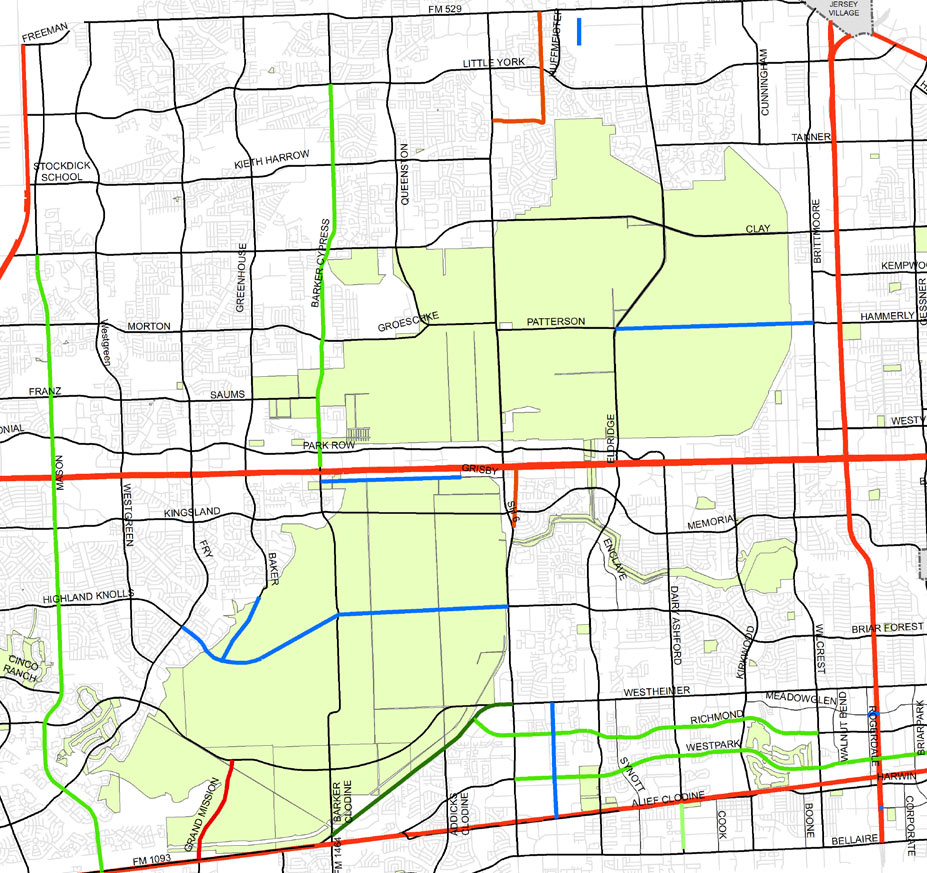
 There’s a rather bold new plan for 2 of the Houston area’s major parkland reserves hiding in an image included in an almost-final draft of the West Houston Mobility Plan being prepared by the Houston-Galveston Area Council for submission to TxDOT. A new roadway connecting Briar Forest Dr. to Highland Knolls Dr. through the heart of 7,800-acre George Bush Park is shown in a proposed major-thoroughfare plan for the area. (See segments in blue in image above.) A segment of Baker Rd. is also shown linking to the new parkway. And north of I-10, a similar major roadway is seen connecting Hammerly Rd. to Patterson Rd. — through the Addicks Reservoir.
***
The proposed major thoroughfare plan showing the 2 cut-through roadways was presented for the first time at the final public meeting of the West Houston Mobility Plan effort on December 18th. At the previous public meeting last summer, a series of slides detailed proposed bicycle path and lane improvements, but those images were not included in the December presentation.
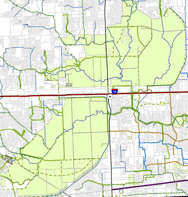
Instead, a single slide (shown below) was used to indicate plans for bikeways, including new bike lanes on Westheimer Pkwy., which cuts through the southern portion of George Bush Park. An existing bike path that serves as a westward extension of Briar Forest Dr. through the park is shown on that map as well. But no new bike lanes are indicated paralleling the proposed new cut-through roads:
 According to the presentation, a final draft of the mobility plan is due this month, but no additional public meetings are scheduled.
After approvals from various transportation committees expected in February, the recommendations are expected to be submitted to TXDot for eventual implementation.
- Meeting Materials [West Houston Mobility Plan]
- West Houston mobility plan in the works [Houston Chronicle]
Maps: Houston-Galveston Area Council

so the plan is to reconnect memorial park by moving roads and building land bridges. and to cut up george bush park by putting in roads. brilliant.
Nice to see such a significant proposal sneak into the presentation at the last public meeting, right? This development was brought up at this week’s Briar Forest super neighborhood meeting and will certainly draw more public scrutiny and feedback. We’re already facing challenges with flood control in the Buffalo Bayou watershed and turning even more upstream land impervious seems unwise, especially in the very area we’re depending on for floodwater detention.
Several thoughts on the George Bush Park cut through:
1) This is going to create a major traffic increase for those that reside near that intersection. There are actual homes on Highland Knolls west of the park and street parking is allowed. They will have to put an end to that, or it will be a horrifying nightmare.
2) Currently there is a bike path/park that will need to be eliminated to accommodate the Highland Knolls extension to the east.
3) This will result in hundreds, if not thousands, of signs with Steve Radack’s name on them.
West Houston? Energy Corridor? George Bush Park? Burbs in general? Meh who cares
this idea would be such a huge waste of money I’m not sure which is more hilarious; the idea that someone gets paid well to do these hypothetical scenarios or that it may actually get built at some point. and we wonder why people hate paying taxes.
It was just a matter of time before CoH destroyed this wildlife refuge. Can you say road kill?
“1) This is going to create a major traffic increase for those that reside near that intersection. There are actual homes on Highland Knolls west of the park and street parking is allowed. They will have to put an end to that, or it will be a horrifying nightmare.”
–
Mike, you’ve piqued my interest. what exactly is the horrifying nightmare with this situation?
Not a fan of this. The boys and I love those unbroken bike paths. Honcho is right about Radack. His name is plastered everywhere over there. Like Dangerfield would say, “he screams his own name during sex”
The answer is always more roads. Protecting green space is not a priority for county and state leadership.
Sneaking in such proposals shows however that much of the public is concerned about quality of life.
I like that in Houston, “mobility plan” doesn’t mean multiple options for getting around, it’s just a map of where new roads are going to be built.
Addendum (as I hit post too soon).
Because let’s be honest, the county will be in a hurry to put down new concrete, but residents will have to fight tooth and nail for any new or improved bike trails.
More roads. Less whiny douche-bags.
Please remember that these parks are just overlays of USACE controlled areas. USACE allows for development in accordance with the federal water resources laws. Environmental and wetlands mitigation may be needed based on impacts.
These projects would also be subject to public comments.
Also, these are just lines on paper. May never happen.
Oh hayll nah. Terrible idea…period.
Well done Texas.
As a resident and worker in the EC, glad to see these proposed. Getting a better street grid is a huge issue in this part of town (and frankly in much of the region). Doing these roads well – meaning designing for multiple modes, limiting toxic roadway runoff, etc. – would benefit multiple transportation modes. And the City of Houston, which might have a better chance of capturing more high-value office space in the EC and Westchase over the long term instead of it fleeing to the Grand Parkway because the Katy Freeway and Westpark Tollway are too congested.
For those of you ragging on Radack, parks and trails are a big point of pride for him.
Still, the USACE is major pain to deal with, so don’t expect these projects to happen soon, unless real political heavyweights – well beyond the local level – can bring a lot of pressure.
Also, let’s not forget — for those of you keeping score on the other side of the bayou, there’s a Kingsland-to-Memorial Drive connector also drawn through the Barker. It’s not drawn in blue because it was introduced in earlier presentations.
Pave paradise, put up a parking lot.
While it is tempting to lay this on CoH, this is clearly an HGAC plan. How can we tell:
1) Highway 6 (running north-south) is hugely congested during rush hour, so the best way to mitigate that is with more east-west intersections.
2) You CAN develop in or near the floodWAY, so obviously there needs to be some roads that go through the floodWAY to allow for development.
3) There aren’t any new bike lanes, or 380 agreements to relocate utilities into those new bike lanes.
The real tragedy/comedy in all of this will be the mitigation measures that developers and road users insist get put into place when they find out that a road built through a reservoir, you know, floods.
Good point slugline. Note that Baker Cypress is not connected all the way through GBP currently, but appears that way on the map.
@Mike Honcho and J:
Hahaha so right about profusion of proclamatory signs with Radack’s brand smeared on them. Although, the same is true for all Harris County Commissioners.
The role of Harris County Commissioner remains one of the most powerful and least accountable political positions in the state of TX. Still amazes me that we maintain this unnecessary layer of government.
so am I really the only one that sees building a very expensive road through an unutilized floodplain to connect sprawling suburban neighborhoods as a gross misuse of funds. this road would spur zero development and additional revenue. the focus needs to be on I10 and improving intra-state traffic through this corridor, not connecting suburban developments of little utility.
You think this is a shitstorm? Wait til COH starts the annexation process of this area.
I’m not sure that I would agree that Harris County has an unnecessary layer of government. However, what I think is really bad is that we have a layer in which people are elected into positions of power by a small fraction of the electorate — most people have a “don’t know, don’t care” attitude.
Also, it’s interesting to reflect on the fact that the parks we’re discussing are on land confiscated from ranching families by the “gubbermint” in the interest of flood control. Seems as if there’s some irony in there somewhere, I dunno …
I sincerely hope that the roads are more meandering than are presented and that the park in their vicinity is landscaped in a way that is beneficial for both commuters and park users. However…I’m quite pleased that there seems to be a commitment to the idea keeping the regional grid of thoroughfares intact and continuous. This would be highly beneficial over the long term.
About the people on Highland Knolls. Yes, their traffic counts will increase. Traffic counts elsewhere will decrease. I don’t expect them to be happy, but its very difficult to find a reason to care if it benefits a vast swath of neighborhoods that aren’t that one.
I would imagine the folks that back up to the proposed west side connector for Highland Knolls, which is currently a park/bike path, will be the most aggravated. Lakes of Bridgewater, Kelliwood Estates and Parklake Village. I could see it as plausible if you forbid parking on Highland Knolls. I don’t see how you can do that to the residents, but I guess they forbid parking on Richmond and San Felipe where there are residential areas.
Widening roads will only lead to more traffic over time. There doesn’t seem to be much of a regard for natural wild space in the Houston area. Not everything needs be paved or developed.
Not sure how this is “hiding.” There was a meeting. I was there, as were many others. The new street links were discussed extensively, including several audience questions about design (e.g. will they be high enough not to flood frequently). You had to drive out there, though, is the thing.
I would support widening existing roads through and around the park and reservoir, such as Westheimer Parkway, TX 6, and Clay, but not building new ones. I think our area needs more undisturbed green space, not less. Widening would make less of an impact to the undisturbed space.
I’d prefer to see plans to create lakes out of these reservoirs instead of plans to add roadways. Add volume for flood prevention–don’t take it away.
The primary purpose of the Federal Barker and Cypress dams is for detention and flood control. We need flood
control in West Houston more than we need roads. Why are the Federal Government and the Army Corps
allowing local officials to dictate the use of the federal dams for roads? Next to come: gas stations and convenience stores.
Believe it. Katy is predicted to be bigger than Pittsburg in 8 10 years.
So, how are them plans for contretin’ more roads through a reservoir lookin’ now?
It seems to be a bad plan to me. When we have heavy rains the extension will be covered with water just as Westheimer Parkway was during the last big flood. Isn’t the first priority of George Bush Park to be a holding place behind the dam for water? The dam was built for the containment of water so downtown Houston does not flood.
this is the most insane plan I’ve seen…and such a waste of taxpayer money. Leave GBP alone !
Any updates to this? Any idea when or if it will happen?
@bobbyray, we seem to have had a few major “rain events” since this plan was first floated.