ADDICKS AND BARKER RESERVOIRS ARE NOW COMPLETELY EMPTY AND READY FOR THE NEXT FLOOD  All water stuck behind the Addicks and Barker dams has now been released, the Army Corps of Engineers announced late yesterday. That means that for the first time since Hurricane Harvey-triggered rains began filling the 24,520-acre reservoirs, they are now dry and available for use again as parkland. The last bits of water actually left the Addicks and Barker reservoirs last Thursday, October 12th, and Friday the 13th respectively; the announcement was delayed, a public-affairs officer tells reporter Amelia Brust, in order to “receive legal guidance.” The Corps, writes Brust, “is now a defendant in multiple lawsuits brought by surrounding property owners who say their homes and businesses were flooded as a result of the dams’ releases.” [Community Impact] Photo of American Shooting Centers and Millie Bush Dog Park off Westheimer Pkwy. in Barker Reservoir, flooded after Memorial Day, 2015: U.S. Army Corps of Engineers [license]
Sign up for the Newsletter
Tag: West Houston

WHAT MAKES WEST HOUSTON THE BERMUDA TRIANGLE OF REAL ESTATE DISCLOSURE  “None of the more than half a dozen residents interviewed by The Texas Tribune and ProPublica after the floods said they knew they were living inside Addicks or Barker — many of their neighborhoods are several miles away from the dams. Several local officials — including Houston’s ‘flood czar’ and a neighboring county executive — said they had no idea the neighborhoods had been built inside the flood pools. Several real estate agents said they didn’t realize they were selling homes inside the pools.” This from the latest exposé on how 14,000 homes came to be located in designed-to-flood areas inside the Addicks and Barker reservoirs. First, the good news: Of those 14,000 homes, only 5,138 of them flooded this time! Among the many additional OMG-worthy revelations from this latest report from the crack Houston-flooding investigations team of Neena Satija, Kiah Collier, and Al Shaw: Of those homes built inside the reservoirs, at least 4,000 of them were built after Tropical Storm Allison hit in 2001. That’s interesting to note, considering that a Harris County Flood Control District report published in 2003 warned that as many as 2,000 acres of private land inside the reservoirs might easily have flooded in that storm if the rains had fallen in a slightly different location. Also included: this little glance at the area’s real-estate future: “One five-bedroom home in Lakes on Eldridge . . . was listed for $678,000 about two weeks before it flooded during Harvey. The seller’s agent, Moira Holden, tried to put a positive spin on things when she updated the online listing that decreased the asking price by $10,000. ‘Unfortunately this stunning home did flood and is being refurbished to the highest spec!’ it says. ‘Fabulous chance to choose your finishes!‘ When asked if she would disclose to potential buyers that the home was inside Addicks Reservoir, Holden didn’t have a clear answer. ‘I will obviously disclose whatever we are required to disclose,’ she said, pointing out that the home wasn’t in a floodplain. ‘I would hope that the buyer’s Realtor would do their due diligence on that.'” [Texas Tribune; previously on Swamplot] Photo of 13119 Shermons Pond, for sale in Lakes on Eldridge: HAR

WEST HOUSTON CAN NOW FLUSH IN GOOD CONSCIENCE  When last we (and the aircraft supplying aerial images to NOAA) left the West District wastewater treatment plant along Buffalo Bayou just outside Beltway 8 at the flooded southeast corner of Memorial Glen, it looked like this: shut down and surrounded by muddy floodwaters sorely in need of its services. That was September 3rd. As of this morning, the city’s Office of Emergency Management reports, both this plant and the one on Turkey Creek off Eldridge between Briar Forest Dr. and Memorial have been restored to full operation. This means persons in ZIP Codes 77024, 77041, 77043, 77055, 77077, 77079, 77080 and 77094 who had been following guidelines to limit their water use are once more free to shower, flush, brush, and otherwise send wastewater down their drains without special consideration of the consequences. [Alert Houston; previously on Swamplot] Aerial image of West District plant from September 3: NOAA

The map above outlines the actual locations of neighborhoods designated by officials yesterday as being at risk from flooding over the back sides of Houston’s dual Buffalo Bayou reservoirs — in advance of actual spillovers, which began last night and continued this morning. The map was put together by Chronicle data reporter John D. Harden, using information from the Harris County Flood Control District. Zoom in and you can identify specific streets and neighborhoods on the upstream side of Addicks (in red) and Barker (in blue) reservoirs.
Names of the affected neighborhoods are listed on the map’s fly-out panel, available by clicking on the icon at the top left corner of the map. Click on the icon at the top right corner to enlarge the map if you need to.
To lessen the risk of flooding to these areas, officials have been releasing water out the other end, through the Addicks and Barker dams into Buffalo Bayou — possibly (depending on bayou water levels) endangering neighborhoods and structures downstream.
- A weary Houston likely to endure catastrophic flooding through Wednesday [Houston Chronicle]
- Officials fear rising rivers, failing levees [Houston Chronicle]
Map: Houston Chronicle

SHELL’S DOWNTOWN OPERATIONS TO SHED OFFICES, SCURRY OVER TO LARGER WEST HOUSTON CAMPUSES 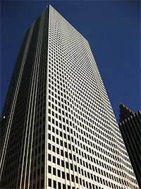 More than half a decade after the local fretting about it started, Shell has announced that it will leave One Shell Plaza, writes Cara Smith this morning. Moreover, the company will drop nearly all of its other Downtown holdings as well, including the previously announced removal of recently-ish acquired BG Group from BG Group Place. Smith writes that the only announced exception to the pullout is Shell’s trading group at 1000 Main; the rest of the company’s downtown workers will move by early 2017 into either the Technology Center at Hwy. 6 south of Richmond Ave. or into the company’s Woodcreek campus along I-10 (south of the Addicks reservoir). [HBJ; previously on Swamplot] Photo of One Shell Plaza: Antonio Foster-Azcunaga

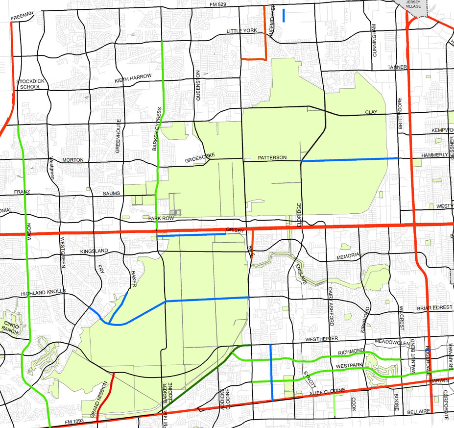
 There’s a rather bold new plan for 2 of the Houston area’s major parkland reserves hiding in an image included in an almost-final draft of the West Houston Mobility Plan being prepared by the Houston-Galveston Area Council for submission to TxDOT. A new roadway connecting Briar Forest Dr. to Highland Knolls Dr. through the heart of 7,800-acre George Bush Park is shown in a proposed major-thoroughfare plan for the area. (See segments in blue in image above.) A segment of Baker Rd. is also shown linking to the new parkway. And north of I-10, a similar major roadway is seen connecting Hammerly Rd. to Patterson Rd. — through the Addicks Reservoir.
Connecting Briar Forest Dr. to Highland Knolls

AEREO’S HOUSTON TEEVEE SERVICE LIKELY A BUST AFTER THIS MORNING’S SUPREME COURT RULING  So which West Houston data center is the one crowded with all those tiny Aereo antennas on its roof? The secret location shouldn’t need to stay secret for much longer, since the Supreme Court issued a ruling this morning essentially declaring the company’s service — which grabs TV signals from local broadcasters and streams them over the internet to subscribers for a fee — to be illegal. In a 6-to-3 decision (with dissent, notably, from the judges generally considered the most conservative), the court declared that Aereo functions similarly to a cable service, and should be subject to the same regulations, copyright laws, and fees charged by television networks. Aereo currently operates in Houston and 10 other cities. [USA Today; previously on Swamplot]Â Photo of Houston West Data Center (probably not the Aereo location) at 5150 Westway Park Blvd.:Â CyrusOne

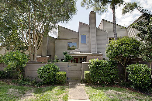
Tilt Creep? The saw-toothed roof of a 1977 Walkers Mark townhome located south of the Energy Corridor and west of Wilcrest Rd. appears to have slanted some of the interior’s fittings as well. If so inclined, grab a protractor and explore all the angles on this property . . .
The Jagged Edge

TURNING THE FERAL HOGS OF BARKER AND ADDICKS RESERVOIRS INTO PORK CHOPS FOR THE NEEDY 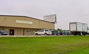 Yesterday county commissioners approved a 1-year contract yesterday with Brookshire’s J&J Packing Co. (pictured at left at 35602 W. Hwy. 90) to slaughter and butcher feral hogs found damaging sports fields and other facilities in and around West Houston’s George Bush Park and Congressman Bill Archer Park and turn them into meat for area food banks. Harris County precinct 3 employees will now be responsible for trapping the hogs and transporting them to the Brookshire plant for processing. “The plan is to trap the varmints in four, 4-acre fenced structures — two in each park — where they can survive for up to several weeks, having grass, water and room to move around,” writes Kiah Collier. “The larger traps will be more effective than smaller ones employees have been using, [Precinct 3 special activities coordinator Mike] McMahan said, because the pigs do not realize they are in a trap and are less likely to panic and warn others. ‘Pigs become very aware of those situations very quickly,’ McMahan said. ‘Pigs are very smart animals.’ But a wildlife disease biologist tells Collier that similar plans tried elsewhere have turned out to be very expensive, and that there are disease risks: “It’s great publicity while it works,” says Brian Mesenbrink with the Texas offices of the USDA’s Wildlife Services, “but the minute something goes wrong, the minute somebody gets sick, there’s going to be all hell to pay. No one thinks about that going into it. They just see the fuzzy and warm side of it.” [Houston Chronicle ($)] Photo: J&J Packing Co.

THE TOP SECRET WEST HOUSTON ROOFTOP CABINETS GRABBING HOUSTON TV SIGNALS FOR INTERNET STREAMING Chronicle tech reporter Dwight Silverman tours the rooftop base housing tens of thousands of tiny, dime-size antennas used by a New York-based company whose business model of capturing local TV, storing it on DVR servers, and streaming it to customers, is headed for a Supreme Court showdown: “Aereo’s local operation is located in a data center in west Houston. (I can’t say more than that – not because of Aereo, but because the data center is very security-conscious and keeps the location secret to protect other customers.) The location was picked partly because TV signals for most of Houston’s broadcast stations are strong there.
The antennas are stored in cabinets mounted on a platform on the center’s roof. To get there, you must climb about 20 feet up a vertical ladder (after receiving a detailed safety briefing) and exit through a hatch onto the roof.
The two cabinets each have a locked door that provides access on one side. Open them, and you can see long circuit-board racks, each about 14-16 inches long, that hold the antennas. Below them is equipment that converts the radio frequency signals to MPEG-2 video. The back side of the cabinets have what [Aereo founder and CEO Chet] Kanojia described as ‘RF transparent windows,’ made of a material that lets TV signals penetrate easily.
The converted MPEG-2 video is fed via 10-gigabit fiber-optic cables to a set of servers in the floor below the roof. Aereo has a relatively small space in the data center, but still has plenty of room to add more servers. A rack of transcoders convert the MPEG-2 video into MPEG-4, which is more easily streamed over the Net.
Two racks of hard drives, each with 3 terabytes of storage and spinning at 7,200 RPM, stores the data. Aereo saves each customer’s signal to the drives, even if they’re watching live, which is what allows its users to pause and rewind live TV. The drives also store recorded shows, with the amount varying based on whether a customer has the $8 or $12 Aereo plan.
When someone wants to watch a show, it’s streamed out through the data center’s big fiber-optic connection to the Internet.” [TechBlog; more info ($)]
Photo of Houston West Data Center (probably not the Aereo location) at 5150 Westway Park Blvd.: CyrusOne

A RANCH-THEMED DEVELOPMENT FOR HOUSTON’S LAST RANCH?  Lisa Gray tries to find out why the owner of the 19 acres at the northwest corner of George Bush Park that constitute the Marks LH7 Ranch has requested that the Texas Historical Commission remove the landmark designation on the grounds of Houston’s last remaining undeveloped ranch: “‘The property hasn’t been maintained for decades,’ explains Mark Wolfe, executive director of the Texas Historical Commission. ‘The buildings are so badly deteriorated that the owner says the property is a public nuisance, that it could hurt people who come onto the property.’ The development that would take the ranch buildings’ place, Wolfe says, would have a ranch theme and interpretive signs. The developers might reuse artifacts from the ranch, such as a windmill. And the ranch buildings would be painstakingly documented before they’re demolished. . . . I called Milo Marks to ask about his plans. ‘We’re working on a project,’ he said. ‘I’ll just wait to talk until May or June. Thank you!’ And with that, the phone went dead.” [Houston Chronicle] Photo: Louis F. Aulbach


A reader catches workers installing the rising-sun Del Taco logo yesterday on the new fast-food joint going in at 8910 Westheimer, on the northwest corner of Fondren. Houston’s first Del Taco in a long long while is expected to open there “soon,” according to the installation crew.
Photo: Swamplot inbox

COMMENT OF THE DAY: RACING AHEAD “Dunno about demolishing before [a] permit is issued. But I do know that when they took down the Nissan dealership on the Katy Freeway a year or so back I was able to look at the already demolished and cleared site on StreetView the day the permit came up in the Daily Demo Report. So it certainly happens.” [Jimbo, commenting on Daily Demolition Report: Chelsea Place Lately]

Reopened yesterday at 12151 Westheimer between Dairy Ashford and Kirkwood: Arpi’s Phoenicia Deli, which crossed the street after 27 years to be closer to Arpi and Zohrab Tcholakian’s flagship (and 2009 Swamplot Award-winning) Phoenicia Specialty Foods store. The new 6,000-sq.-ft. space at the front of the shopping center will still feature shawarmas and salads, but mixes in a new Phoenicia-branded coffee house — and gelato, in classic flavors like Pistachio & Orange Blossom and Cardamom Turkish Coffee. A new Phoenicia Specialty Foods location — in the ground floor of One Park Place across from Discovery Green Downtown — is scheduled to open later this year.

COMMENT OF THE DAY: THE GREAT WEST HOUSTON DIVORCéE BELT “It basically runs in between Beltway 8 and 610 and is crossed by the likes of Westheimer, Woodway, Richmond, Bissonnet et al. Basically these people met in drunken stupors along the Richmond strip in the early 80s at those cheesy night clubs; tried to make lasting marriages but eventually divorced; and then bought homes and patio homes close but not too close to their old stomping grounds. Incidentally, many of them work non-descript office jobs at middle market companies in the Westchase district and raaaaaave about the tres leches cake at the Churrasco’s out there on Westheimer. Yay Divorcee Belt!” [Bobby Hadley, commenting on Neighborhood Guessing Game: Blue Check]