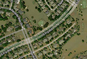
WHEN GOOGLE MAPS REVEALS YOUR HOME’S SOGGY SHAME  “Google Maps has outed us as a city that floods,” laments meteorologist Brooks Garner, giving voice to would-be sellers of flooded homes worried that recent soggy aerial views will remain in the mapping system for years: “It should be said that legally, home owners must disclose if their home has ever flooded (or even if their property has flooded, while their actual house stayed dry). While that’s defeating enough to have to do, words are less influencing to a buyer’s decision than seeing an actual image of the inundated neighborhood. It arguably gives the impression that the water is still that high. . . . KHOU 11 has featured Realtors on our News at 4pm who’ve speculated that once people ‘forget’ about the floods, depressed home values in submerged areas will return to their pre-Harvey prices. (At least one realtor with that opinion was a victim of flooding himself, so I wonder if that fact influenced his statement.) . . . Here are several other ‘unfair’ things: Neighborhoods which experienced short-term flooding, but saw it subside after a day or two, were largely missed by the Google satellite update. They look high and dry. The only ‘tell’ in some is the trash which is piled high along the sidewalks. Drywall, couches, mattresses and furniture making up these walls of debris. It’s so extensive in places like Meyerland you can see [it] from space. In other areas like Hall Rd. off Beamer in southeast Houston, the satellite-update at time of this blog’s publishing apparently ‘missed’ the neighborhood and as a result, things look totally normal despite the huge mounds of refuse still present today.” [KHOU] Screenshot of Cinco Ranch on Google Maps: KHOU


Is it still possible to see these images on Google maps? They don’t show up any more in historical imagery on Google Earth.
The images are still online, but as it shows above, the images were taken on Wed. This is well after the flooding and some homes had not yet removed debris from their home.
It would be interesting to see an overlay of the area flood maps and where the flooding claims are located.
These aren’t Google images. Google has access to them from NOAA who flew all week after Harvey from Rockport through Beaumont/Port Arthur.
Images started to be flown on Sunday in Rockport and continued to be flow through next weekend. Much of Houston was covered on the Wed (8/30/2017) flights. The images primarily used to survey wind damage and the extent of the reservoir and Brazos River flooding. Localized street flooding or short term riverine flood would not be captured.
They are still on Google Earth and NOAA has a website that it actively updates. These images will also be made available. Our GIS (Geographical Information Systems) user have already received them.
Realtors are so out of touch with reality. No one will buy previously flooded homes unless it’s a moron doing the buying or a lowball offer to snag the land.
Unfortunately Mr. Truth is telling the truth. Given the choice between flooded and non flooded the price better be WAY less and anyone that flooded should never spend a dime to upgrade or modernize.
Ehhhh, yall act like Galveston doesnt get rebuilt after EVERY hurricane. I always heard it takes people 7 years to forget a coastal hurricane, but after Ike it was closer to 5. I dont think it is apples to apples with the flooding in Houston, especially with the people that flooded 3 times in 3 years. But look at all of the homes on Boliver now, versus what was there after Ike.