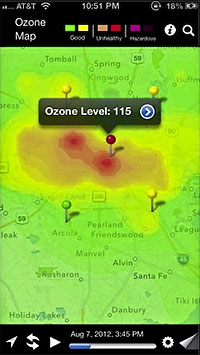
NOW ON YOUR MOBILE DEVICE: WHY YOU CAN’T BREATHE  A team comprising researchers at UH, Air Alliance Houston, and the American Lung Association have launched OzoneMap, an app that “monitors chemical weather,” reports John Metcalfe of The Atlantic blog Cities. And whether the app helps explain your coughing fit or alerts you to the chance of a really pretty toxic sunset, the best part is that it’s only available in Houston! And why Houston, of all places? Besides the industrial flares, that is? Here’s Metcalfe: “The Houston/Baytown/Huntsville region comes in eighth place for most ozone-polluted cities in America, as ranked by the American Lung Association. Persistently sunny weather, a battalion of petrochemical facilities and scads of fuming cars on the road make Houston a nightmare for anyone who’s chemically sensitive. For these folks, walking outside is like playing a lower-stakes version of Russian roulette, with 30 to 40 days of the year fogged with hazardous levels of ozone.” [Cities; previously on Swamplot] Map: Cities


One other reason why this is only available in Houston: The TCEQ (with the help industries it regulates) has created the most comprehensive network of ozone monitors in the country, and shares the data real-time with the general public. We may not have the cleanest undies in the nation, but at least we are not ashamed to show them (unlike most other cities, which ignore the issue and try to hide where their pollution problems are).
The ozone levels in Houston still beed attention, but they are greatly improved from 10 or 20 years ago, especially considering the growth in roads, industry, and population since then.
This is not a Texas-exclusive thing. China has had (and needed this) for a while.