11/16/17 11:30am

The U.S. Chemical Safety Board’s animated video (above) on the explosions at the Arkema Chemical Plant in Crosby recounts the steps taken by the brave workers stuck in charge of the facility in the aftermath of Hurricane Harvey. But a few angles less charitable to the company’s emergency planning effort aren’t included — possibly because they’d be a little more involved to animate. For example, the noxious fumes that emanated from the first fire, on the night of August 31, which according to a lawsuit filed later Arkema gave no warning about — and sent 23 people to the hospital, many of them vomiting and gasping for cleaner air.

And another detail: The remote detonations of 6 trailers containing unrefrigerated organic peroxides were carried out by the Houston Police Department’s bomb squad. “The entire police operation was conducted without warning the public,” write the Houston Chronicle‘s Matt Dempsey and Jacob Carpenter. “Until the documents were released earlier this month by the EPA, the public didn’t know who performed the controlled burn, or how it was done.”

CONTINUE READING THIS STORY

Reefer Madness
09/07/17 3:45pm

SOMETHING POWERFUL IN THE CROSBY AIR 
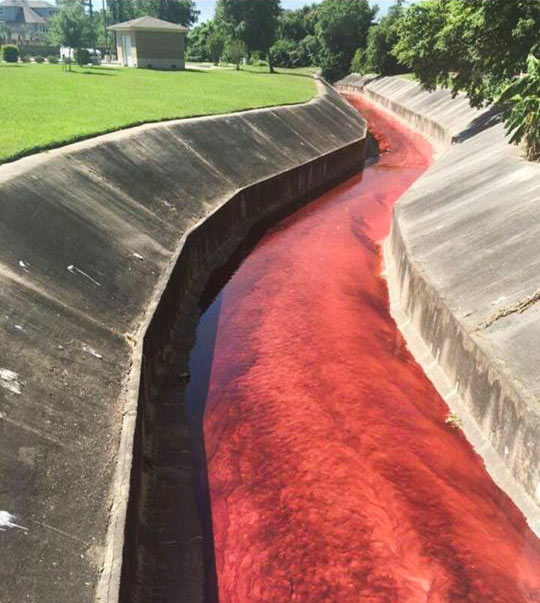
This vivid description is included in the original petition of a lawsuit filed today against Arkema, operators of the chemical plant off the Beaumont Hwy. in Crosby — by 7 first responders injured after incidents there last week: “In the early morning hours of August 31, 2017, the first of several explosions occurred as a result of the abandoned chemicals heating up and igniting. Although the explosions had occurred, no one from Arkema alerted the first responders who were manning the perimeter of the arbitrary mandatory evacuation area. Immediately upon being exposed to the fumes from the explosion. and one by one. the police officers and first responders began to fall ill in the middle of the road. Calls for medics were made, but still no one from Arkema warned of the toxic fumes in the air. Emergency medical personnel arrived on scene. and even before exiting their vehicle, they became overcome by the fumes as well. The scene was nothing less than chaos. Police officers were doubled over vomiting, unable to breathe. Medical personnel, in their attempts to provide assistance to the officers became overwhelmed and they too began to vomit and gasp for air. Some of the police officers. unable to abandon their vehicles due to their weapons being present, jumped in their vehicles and drove themselves to the nearest hospital. The other officers and medical personnel were all placed in an ambulance, and were driven to the hospital.” [Houston Chronicle; International Business Times] Still image of smoke from fire after Thursday’s explosion: abc13

07/07/16 5:30pm

Spring Branch tributary after Laverne St. Fire

A Houston Chronicle attempt to get more info about the surprise chemical warehouse fire that turned Spring Branch Creek blood red earlier this year has been denied by the city, writes Matt Dempsey this week. The city has reportedly appealed to the state attorney general’s office to block the records request, as well as the paper’s broader request for “the name and address of every facility that files a hazardous material inventory form.”

The early May fire spread from a residence on Laverne St., igniting still-unquantified amounts of still-unnamed chemicals stored at the Custom Packaging & Filling warehouse behind it — a business that didn’t show up on the list of storage facilities the Chronicle was able to compile from local emergency planning groups, after the city and state blocked a previous request for similar info last year. The blaze left some firefighters with chemical burns and respiratory issues, and left stretches of nearby waterways decorated with festive biohazard signs and oil booms as the EPA did what they could about the mixture of pesticides and whatever else was killing the fish that drained from the site.

CONTINUE READING THIS STORY

Knowing Your Neighbors
02/03/16 10:30am

Slide 13 of US CSB Public Meeting, Waco, TX, January 28, 2016

The image above, showing a fertilizer-grade ammonium nitrate (FGAN) facility loitering as close as 529 ft. from the edge of an unidentified school campus, appeared on slide 13 of a US Chemical Safety Board presentation in Waco last week. But where is this place? And where are the other Texas locations where similar facilities storing large quantities of ammonium nitrate are sited within half a mile of a school? The Board warns that there are 18 such cozy-ups in Texas, but doesn’t identify their locations — even the image shown above, grabbed from Google Earth and outlined, omits any street labels.

The Waco presentation talked through the safety agency’s recently released findings on the 2013 explosion in West, Texas (located in Central Texas). A school and a nursing home were among the nearby buildings that received serious damage from the fertilizer blast, which killed 15 people and injured hundreds; the safety board report indicates that holes in that city’s zoning laws allowed the storage facility to be slowly grandfathered into a residential area.

Finding out where chemical storage facilities are located, and what they store, is now more of a fun guessing game than it was before the West explosion: In 2014, then-attorney-general-now-governor Greg Abbott’s office ruled that state Tier II data, which documents hazardous chemical storage at private facilities, would no longer be accessible to the public. But those open records weren’t really necessary, not if you’re really trying to find the facilities: “You know where they are, if you drive around,” Abbott told reporters.

CONTINUE READING THIS STORY

West Explosion Aftermath
05/30/13 4:35pm

HOW HOUSTON’S AIR GOT BETTER During the past decade, Houston’s notoriously polluted air has become — well, if not quite good, then not quite as bad, says NPR’s Richard Harris. (Pay no attention to what that ozone app may or may not tell you.) How? Well, it seems that pollution regulators in the early aughts had been worrying about all the wrong gases: “They were going all-in against [only] one of the pollutants that create smog, while downplaying the role of other emissions from the petrochemical plants,” reports Harris. “Barges carting chemicals up and down the [Ship Channel] were leaking. . . . And some types of storage tanks were leaking as well. . . . It turns out that routine day-to-day emissions were not the biggest problem.” Since then, regulations targeting those chemicals, like ethylene — as well as the use of infrared cameras that can spot them — appear to have made a difference: Port of Houston Authority employee Dana Blume tells Harris: “I can look out of my office window now and almost every single day see downtown.” [NPR; previously on Swamplot] Photo: Flickr user stmu_mike

07/27/12 1:55pm

WHERE ALL THOSE NEW CHEMICAL PLANTS ARE GOING It’s Houston’s plastics boom!Chemical companies from around the world are flocking to the Houston area,” declares the Houston Business Journal, “to take advantage of vast amounts of cheap natural gas, which is used as a chemical feedstock.” The publication counts 8 new or expanded facilities. This handy map shows where they’re headed: Baytown (a new ethane cracker at Chevron Phillips Chemical and expanded ethylene and polyethylene facilities at the ExxonMobil plant), Old Ocean on Hwy. 25 (2 new polyethylene facilities, also for Chevron Phillips), Freeport off Brazosport Boulevard (an ethylene cracker for Dow Chemical), 8280 Sheldon Rd. in Channelview (an expansion of LyondellBasell’s existing ethane facility), 1515 Miller Cut-Off Rd. in La Porte (expanding LyondellBasell’s ethylene plant there), near Alvin on FM 2004 (more ethylene processing at INEOS’s Chocolate Bayou plant), and Clear Lake (a new methanol production plant at the existing Celanese facility). Welcome! [Houston Business Journal] Map: Houston Business Journal

09/06/11 2:12pm

PICKING UP CASH FOR THE CHEMICAL SPEW How did Harris County government swing half a million dollars in cash from Shell Chemical? The company is turning over that amount as part of a settlement covering 5 unreported chemical releases between April 2008 and March 2010 at the company’s Deer Park plant on Hwy. 225 just east of Beltway 8. According to Harris County’s lawyer on the case, Shell Chemical also made an “important concession,” which will likely result in more advance warning of similar future windfalls headed our way: Shell says it’ll now alert the county’s local pollution control office, and not just state officials, of “pollution events.” [Pasadena Citizen]

08/03/10 12:23pm

IF THE SILO’S ROCKIN’, DON’T COME A-KNOCKIN’ The strange noises and clouds that’ll be emerging over the next 6 months from the Bayport Polymer plant at 12001 Bay Area Blvd., a few miles south of the La Porte Municipal Airport, are nothing to worry about, LyondellBassell wants you to know. Just a little demolition work: “Periodically during the coming months, people close to the facility might detect rumbling noises, loud thuds, vibrations or dust clouds. ‘We will continue to communicate to our community in advance via the CAER Line, CAP groups and E-Merge/E-Notify when work is being done that our neighbors might notice. We apologize for any inconvenience this situation may cause,’ stated a company press release.” [Bay Area Citizen]

04/28/10 1:54pm

COMMENT OF THE DAY: CLEAR LAKE CITY CLEANS UP NICELY “Is there a discount [for homes near chemical plants]? Hell yes! And it’s for lots of reasons: 1) real or perceived pollution, 2) real or perceived high crime, 3) low elevations, 4) higher property insurance rates, 5) fewer nearby white collar jobs, and 6) living there indicates to snobs that you’ve got a low social status. Most of the discount is unwarranted, but it’s a self-fulfilling prophecy. Look at Clear Lake City; parts of it are only about 1.5 miles from the nearest chemical plants. It was developed upon depleted oil fields and is adjacent to still-active fields. (It was developed by a subsidiary of Exxon!) It’s adjacent to an airport. It has a low elevation. But all that stuff is out of sight, out of mind, and so there’s no stigma.” [TheNiche, commenting on House Shopping in the Chemical Discount Zones: Finding Houston’s Less-Toxic Neighborhoods]

04/27/10 2:41pm

HOUSE SHOPPING IN THE CHEMICAL DISCOUNT ZONES: FINDING HOUSTON’S LESS-TOXIC NEIGHBORHOODS “A commenter on your blog who says he works at a chemical plant recently wrote that a neighborhood 1 mile from a chemical plant ‘is never going to be an “OK” neighborhood.’ Is there a single citywide map that shows where all these plants are, so I can find a place to live accordingly? And how far do I have to be from a chemical plant to be ‘OK’? 5 miles? 20? I presume there’s no absolute answer. But there’s got to be a de facto ‘discount’ on homes in neighborhoods that are within certain radiuses of the toxic stuff, right? If so, how far do the discount zones extend? Could someone draw that map for me?” [Swamplot inbox]

03/03/10 4:30pm

COMMENT OF THE DAY: WE’RE FROM THE TEXAS MEDICAL CENTER AND WE’RE HERE TO HELP “Given all the refineries, industrial plants, chemical plants, railroads, stagnant swamps and cesspools, traffic pollution, and the like that plague this hellhole of a town, it is a freaking wonder that Houston doesn’t lead the nation in cancer cases.” [Random Poster, commenting on Today’s Odor in Baytown Is Brought to You by ExxonMobil]

12/23/09 10:41am

HOW THE TCEQ HELPS HOUSTON AIR STAY SO FRESH AND CLEAN Combing through emissions reports for 20 local refineries and chemical plants from February 2003 through October of this year, reporter Chris Vogel notes how the peculiar accounting method employed by the Texas Commission on Environmental Quality seriously underrepresents Houston-area emissions events: “In slightly more than six and a half years, the 20 plants pumped out 4,864,730 pounds of sulfur dioxide, 452,080 pounds of carcinogens and a total of 20,716,547 pounds of pollutants during emission events . . . The Press discovered that individual chemicals at the 20 facilities exceeded the limit 12,701 times during the six and a half years. [But] TCEQ documents obtained through an open records request for the 20 plants show that the agency found 469 violations over the past six and a half years, 240 of which listed excess pollution during an emission event as the reason. Those 240 violations represent less than 2 percent of the number of times that individual pollutants exceeded their limit during emission events. Many people, including former TCEQ Commissioner Larry Soward, see this as one of the ways TCEQ gives industry a big break.” [Houston Press]

12/09/09 11:57am

Here’s a view from a Seabrook resident’s home this morning, looking across the way to the American Acryl acrylic-acid plant at 11600 Port Rd. off Old Texas 146, less than a mile east of the newer Hwy. 146. A loud chemical explosion is certainly a lot to get excited about in the morning, but people in the area may just want to go back to bed:

Area residents were asked to shelter in place after the blast, but that recommendation was lifted by 11 a.m. Officials said the blast involved toluene, a toxic substance that can cause nausea and tiredness in low to moderate levels.

However, in a recorded message company said the explosion did not cause a release of the chemical.

Update: From NASA engineer Jim Thompson, here’s a collaborative map showing the observations of people nearby, including a photo of the blast as seen from the Johnson Space Center.

Photo: Twitpic user nelagster

07/10/09 1:51pm

COMMENT OF THE DAY: IT’S WHAT’S INSIDE THAT COUNTS “Houston ugly? Hell no. Houston is real. Houston has the testicular fortitude to manufacturer [goods] and chemicals that everybody wants but no one wants made near them. Same with Beaumont, Port Arthur, Lake Charles, Baton Rouge…..I’ll take Houston gladly over cities that are completely obsessed with looking good. . . .” [kjb434, commenting on Smaller Signs in Houston’s Future]

07/09/08 12:39pm

[youtube:http://www.youtube.com/watch?v=l6btY7WqNBM 400 330]

Frustrated that his occasional reports on area petrochemical-plant emissions events haven’t received more attention, Banjo Jones of the Brazosport News (aka former Chronicle reporter Steve Olafson) resorts to video. His first feature: the odorous results of a power outage this past Sunday at the Chevron Phillips chemical plant in Old Ocean. That’s in Brazoria County, about an hour’s drive southwest of Houston.