THE BIG WET PICTURE FOR A POSSIBLE HARVEY HANGOUT  A Hurricane Harvey shown veering slightly further to the east than previous reports suggested is now expected to reach the Texas coast late Friday night or early Saturday morning as close as 125 miles southwest of Houston — with a rating at the high end of Category 3. But heavy rainfall could continue for days if the storm stalls or retreats instead of moving inland and clings to the coastline as it travels east. The National Weather Service now expects flooding in the Greater Houston area and points east to continue through Tuesday, with rainfall ranging from 15 to 25 in. [Space City Weather; National Weather Service] Image: National Weather Service
Sign up for the Newsletter
Tag: Hurricanes

SCENIC UPPER TEXAS COASTAL SWAMPS, BEACHES, PLANTATIONS A LITTLE CLOSER TO GOING NATIONAL 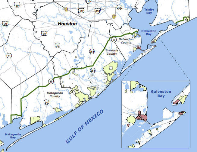 Jefferson County’s commissioners are the latest to give a formal thumbs up to a proposal for the Lone Star Coastal National Recreation Area, which would bundle together a patchwork of parks, historical sites, and variously refinery adjacent nature preserves from the Bolivar peninsula down to Matagorda Bay. The concept for a regional rec zone was developed shortly after Hurricane Ike’s big splash on the Texas coast in 2008: researchers noticed that some of those larger patches of undeveloped wetlands helped buffer storm surge damage, and started looking at whether keeping them around could be profitable in other ways. No new land would be scooped up for inclusion in the 4-county zone, unless it were offered voluntarily — but the whole region would be marketed under the National Parks Service’s banner as a package to birdwatchers, beachgoers, Strand-walkers, and the like. The proposed area would still need some level of National Parks Service staff, and approval from Congress — which is currently considering major cuts to the Department of the Interior’s budget. [Beaumont Enterprise; Houston Chronicle] Map of proposed Lone Star Coastal National Recreation Area: LSCNRAÂ

COMMENT OF THE DAY: WHAT MADE THE GEOGRAPHY THAT MADE HOUSTON  “Air conditioning had little to do with it. Chicago out-paced Houston because of its location as the geographic nexus of industrial transportation during the industrial revolution. It connected to the east through the Erie Canal and Great Lakes and to the west with the ever-growing railroads. A linchpin city grows. A growing city builds. Houston had no such geographic importance — and had a hurricane not made Galveston nonviable, Houston would probably still be a modest town. We had to build our port to earn any geographic value. It’s impressive that we did so. Houston shouldn’t exist. We made it exist. Now that’s cool.” [Matt, commenting on Comment of the Day: When Houston Chilled Out and Grew Up] Photo of Houston Ship Channel: Russell Hancock via Swamplot Flickr Pool

WAIT, DID THE 2008 RECESSION UP THE CHANCES OF A FUTURE HOUSTON CHEMICAL CATASTROPHE? 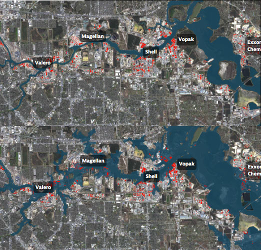 Roy Scranton imagines “a wave of water sweeping toxic waste into playgrounds, shops and houses” in Magnolia Park in his op-ed this morning, written after touring the Ship Channel and speaking with the local A&M and Rice research teams pushing for variations on a series of region-scale coastal barriers to hunker down behind whenever the next gigantic hurricane hits the Houston region, in hopes of avoiding deadly flooding and catastrophic chemical spills. But the researchers tell Scranton that pushing for federal and state funding for a response is a slow endeavor; Jim Blackburn (a main player on the Rice team) tells Scranton that he’s “heard more than one person say our plan is to wait until the next hurricane comes, then depend on guilt money from Washington to fix the problem.” Scranton writes that the best chance for that guilt money so far might have been in 2008, when Hurricane Ike landed just 30 miles northeast of the zone that modelers say could have caused thousands of deaths and irreparable ecological devastation to the area, on September 13th — 2 days before the Lehman Brothers filed for bankruptcy, pulling global attention and national funds to other issues as markets began to crash. [NY Times; previously on Swamplot] Model maps of potential storm surge flooding along the ship channel, with chemical storage marked in red: Texas Tribune

THE NEXT BIG HURRICANE REBUILD WILL GO MUCH FASTER IF YOU START ON IT NOW Meanwhile, in Brownsville: Housing advocates in Dolly-battered South Texas have since developed a disaster response program optimistically called Rapido; new legislation (similar to a bill that failed in the last Texas legislative session) is in the works to make Rapido-style “precovery” response a statewide standard. The program involves the fast deployment of permanent 1-room housing “cores” that can be quickly assembled by local workers and then added onto later; the bigger component of the program, Leah Binkovitz writes this week, is extensive pre-planning initiatives in potential disaster areas, instead of what housing advocate John Henneberger calls “reinventing disaster recovery from a blank sheet of paper every time there’s a disaster.†Binkovitz writes that the program calls for preemptive outreach “to determine what kind of disaster housing would be most appropriate, who could build it, who would be eligible to receive it and what resources would be available. That conversation should even include whether folks want to rebuild in vulnerable neighborhoods and how to offer alternatives.” [Urban Edge; previously on Swamplot]
RE-PEARING THE PEARLAND BRAND 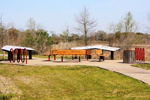 The Pearland Convention and Visitor’s Bureau is now selling sponsorships for the 4-ft.-tall decorated fiberglass pears it plans to place around the city to generate enthusiasm from tourists and boost the organization’s branding efforts. Executive director Kim Sinistore tells Amy Bishop that the group “would like to bring pears back to Pearland in the landscaping.†The Pearland city government’s account of the area’s history, however, largely glosses over the importance of pears, instead playing up the historic importance of figs to the region (particularly after the settlement’s  near-destruction by the 1900 Galveston hurricane, and second near-destruction by the storm of 1915). A donation of $4000 gets your name and logo onto a plaque by the themed pear of your choice (on a first-come-first-serve basis), along with other perks; sponsors can also go in on a pear with a friend and split the price. [Houston Public Media, City of Pearland] Photo of Shadow Creek Ranch Nature Trail, one of 5 planned pear deployment zones: City of Pearland


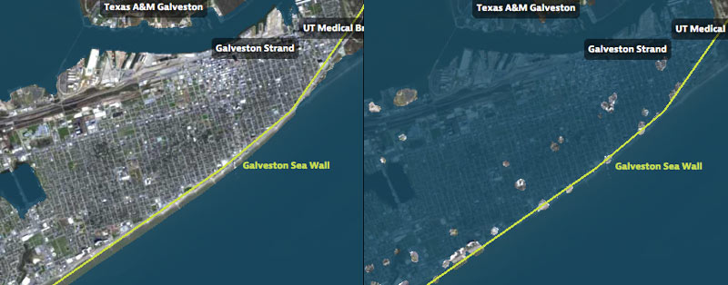
That’s Galveston Island going for a dip in the before-and-after captures above, from a set of interactive timelapse maps released by the Texas Tribune and ProPublica yesterday (along with several articles by authors Kiah Collier and Neena Satija). The new maps model flooding across the Houston region during Hurricane Ike — as well as what would have happened if Ike had actually hit just south of Houston, as meteorologists initially expected.
The maps are your chance to relive an old disaster, or to see how many of your neighbors you can take out with a hypothetical-but-not-unrealistic future storm: users can pick between Ike, south-er Ike, a storm 15% stronger than Ike (nicknamed Mighty Ike), and a modeled 500-year storm (which the article suggests may actually be a concern on the every-few-decades-or-so level; ‘500-year’ has always meant ‘a low probability in any year’, and climate change is shaking up old modeling assumptions). The graphics also include a few dramatic face-offs:Â Mighty Ike and the 500-year storm VS. 2 of the miles-long multi-billion-dollar coastal protection projects being studied for the upper Texas coast.
You can even search for your home address in the map system to see what flood levels might look like in your own back yard. Here’s what the maps show happening to the Clear Lake, Seabrook, and League City areas at the peak of the 500-year storm model’s storm surge, which the article says is a “not if, but when” event:
Hell and High Water

SHAKING AT THE TOP OF A HOUSTON SKYSCRAPER IN THE MIDDLE OF A HURRICANE  Houstonians who were around for Hurricane Alicia in 1983 might remember that the Wells Fargo Plaza tower downtown — then known as the brand-new Allied Bank Plaza — ended up losing more than 3,000 glass panels in the storm. But did you know that the building that night became the site of one of the few live wiggling-skyscrapers-in-a-storm experiments ever conducted? Engineers Robert Halvorson and Michael Fletcher spent the night of the hurricane in the 71-story tower’s unfinished top floor, just to see how much the building would sway; more than 30 years later, they described their experiences to Washington Post reporter Emily Badger. The peak acceleration of 43 milli-g’s they recorded — enough back-and-forth and twisting to make it impossible for them to walk upright — turned out to be “give or take, exactly the same thing that had been predicted by the wind tunnel” before the structure was built. [Gizmodo] Photo of Wells Fargo Plaza: Jackson Myers

BUILDING A MONUMENT TO GATED FLOOD CONTROL AND TOURISM  Protecting the Ship Channel during an Ike-like (or worse) storm surge has led some to propose a big dike, others a big gate. But UH professor of urban planning Tom Colbert doesn’t see why we couldn’t trouble ourselves to make such protection a real sight to see too: “Colbert likes the idea of . . . connecting the Centennial Gate and its levees to the proposed Lone Star National Recreation Area, undeveloped land that would both attract ecotourists and slow floodwaters,” reports the Houston Chronicle’s Lisa Gray: “I remembered one drawing I’d seen in [Colbert’s] PowerPoint show: Happy tourists, paddling kayaks past the Hartman Bridge, on one of the byways out of the big ships’ path, waterbirds and wetlands all around. Colbert motioned southeast, toward the Ship Channel’s mouth, toward Barbours Cut, the other possible location for the floodgate. There, he said, the levees would cross the channel’s water, connecting the Ship Channel’s artificial islands — made from dirt dredged from the channel — to the shore. Enough room could be left on top of the levee for a hiking path or even for car access; for the first time, it would be possible for people to get to the Atkinson Island Wildlife Management Area — a bird mecca on manmade land — without a boat. You could even, he notes, build a tourist destination atop one of those islands: He proposes a monument to Houston, the gateway to North America, the place where nature meets industry. In some drawings, just to give people the idea, he plunks the Statue of Liberty atop a Ship Channel island.” [Houston Chronicle ($); previously on Swamplot] Photo of Fred Hartman Bridge: Chuck Wilkson


What could possibly have been worse than Hurricane Ike? Super Ike, a stronger hurricane aimed 30 miles further west, causing a larger storm surge, more deaths, and significantly greater damage to Houston’s industrial infrastructure. To protect against that hypothetical $100 billion threat, a Rice University team is recommending some bolstered defenses for the region. Included among the suggestions: a “moveable gate structure” just upstream from Baytown’s Fred Hartman Bridge, to block the Ship Channel and San Jacinto River from rising waters in Galveston Bay (pictured above); elevating Hwy. 146 along the west edge of Galveston Bay so that it forms a levee protecting much of La Marque, Dickinson, League City, Clear Lake, and La Porte; a “baywall” to protect Galveston Island’s backside from sneaky storm surge waters; and preserving a 130-mile-long stretch of existing coastal wetlands between High Island and Matagorda as a recreation area and when-needed storm barrier.


Houston ranks 5th — below Long Island, Miami, Virginia Beach, New Orleans, and Tampa — in potential property damage from storm surges, according to an annual report from Corelogic. The company figures the resulting storm surge from a Category 5 Hurricane here would likely produce $20 billion in property loss — well behind Long Island’s $99 billion score. Can’t this city do a little better? We’ve got the high-hurricane-risk and low-lying-properties parts down cold. If we can just boost the property values a bit in those areas, we’ll be rolling with the high-stakes big boys next time.
The top at-risk area Zip Codes, according to the company’s report: 77573, 77554, 77059, 77571, 77062, 77566, 77586, 77539, 77546, and 77521. Locally, League City leads the way!
- 2011 Storm Surge Report [CoreLogic]
Image: Corelogic

LIVING IN THE SOG ZONE As Hurricane Alex heads for the northern banks of Mexico more than 300 miles away and the National Weather Service issues a coastal flood warning, the Chronicle‘s Clear Lake website offers this bit of advice: “Residents throughout Clear Lake and the rest of the Houston area should watch for street flooding in the usual areas.” [Ultimate Clear Lake]
HURRICANE IKE’S LOUSY AIM Director Phil Bedient comments on a report released today by Rice University’s Severe Storm Prediction, Education and Evacuation from Disasters Center (SSPEED): “‘Ike was a Category 2 hurricane, and it caused $30 billion in damage. Had that same storm struck 30 miles farther south, it could easily have caused $100 billion in damage. Had it struck that location as a Category 4 storm, like Carla, the results would have been catastrophic.’ . . . Bedient said one need look no further than the Houston Ship Channel to get a clear sense of the region’s vulnerability. The ship channel is home to one of the nation’s busiest ports and about one-quarter of U.S. refineries. The Coast Guard estimates a one-month closure of a major port like Houston would cost the national economy $60 billion. Despite this, government regulations require dikes and levees that can protect ship channel facilities against only the 100-year flood of 14-15 feet. Bedient said that based upon results from supercomputer models at the University of Texas, Austin, Ike could have caused a 20- to 25-foot storm surge along the ship channel if it had struck about 30 miles farther south.” [SSPEED, via Memorial Examiner; report (PDF)]

Too bad we can’t embed the video here. So here’s a transcript of the rationale — presented by the writers of the Discovery Channel’s Mega Engineering series — for building that massive, mile-diameter geodesic dome over Houston (or at least the Downtown part):
Houston, Texas — the country’s fourth most populous city — is in peril.
Houston has always been vulnerable to killer hurricanes: From the great storm of 1900, the deadliest in U.S. history, which killed 8,000 people, to Hurricane Ike in 2008, which caused more than $10 billion in damage, and forced the city center to shut down for nearly a week.
And it’s not only hurricanes. Searing heat and humidity also oppress this great city. On nearly 100 days each year, the temperature climbs above 90 degrees, which in muggy Houston feels even hotter.
Air conditioning provides relief, but at a cost. Houstonians’ soaring electricity use has nudged the city ahead of Los Angeles in the race to become the country’s number-one producer of greenhouse gases — a dubious distinction. And the problem is only getting worse.
Forced to spend a fortune in a losing battle against nature, and with energy costs spiking unpredictably, Houston finds itself square in the path of an environmental juggernaut, which threatens to make the city unlivable.
That’s why some think that the only way to save Houston is to move it indoors.
- Saving Houston with a Dome [Mega Engineering]
- We’re All Astrodome Now: The Mile-Wide Dome Over Houston [Swamplot]
Diagram of Houston Dome: Engineering, Discovery Channel
