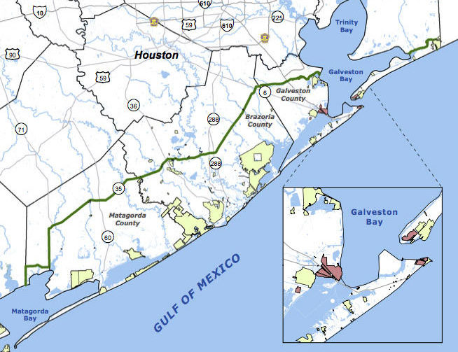
SCENIC UPPER TEXAS COASTAL SWAMPS, BEACHES, PLANTATIONS A LITTLE CLOSER TO GOING NATIONAL  Jefferson County’s commissioners are the latest to give a formal thumbs up to a proposal for the Lone Star Coastal National Recreation Area, which would bundle together a patchwork of parks, historical sites, and variously refinery adjacent nature preserves from the Bolivar peninsula down to Matagorda Bay. The concept for a regional rec zone was developed shortly after Hurricane Ike’s big splash on the Texas coast in 2008: researchers noticed that some of those larger patches of undeveloped wetlands helped buffer storm surge damage, and started looking at whether keeping them around could be profitable in other ways. No new land would be scooped up for inclusion in the 4-county zone, unless it were offered voluntarily — but the whole region would be marketed under the National Parks Service’s banner as a package to birdwatchers, beachgoers, Strand-walkers, and the like. The proposed area would still need some level of National Parks Service staff, and approval from Congress — which is currently considering major cuts to the Department of the Interior’s budget. [Beaumont Enterprise; Houston Chronicle] Map of proposed Lone Star Coastal National Recreation Area: LSCNRAÂ
Bolivar Peninsula
THE POWER BALLS HAVE ARRIVED! Okay, fess up: Which one of you has been secretly transporting oil from the Deepwater Horizon gusher to our local beaches? The Coast Guard reported over the weekend that up to 5 gallons of dime- to ping-pong-ball-size tar balls collected from the surf along East Beach in Galveston and the Bolivar Peninsula’s Crystal Beach came from BP’s little offshore accident. But surely the little bugger-balls can’t have been trying to swim all the way back to headquarters? “[Coast Guard captain Marcus] Woodring said the condition of the tar balls didn’t look like they had drifted all the way from the Macondo well. They were ‘inconsistent with the weathering pattern that would be expected,’ he said. ‘To travel 400 miles is going to take a long time,’ during which the oil would be expected to break down. Officials were investigating whether the tar balls were from oil that clung to the hull of a ship passing through the BP oil slick or were from ballast water taken on by a ship in the oil slick zone and later dumped in Texas waters, Woodring said.” [Houston Chronicle]
GALVESTON TAR BALLS UNDISTURBED BY OIL SPILL “If oil from the spill reaches Texas, it will likely be in the form of tar balls, said Capt. Marcus Woodring, U.S. Coast Guard sector commander for Houston-Galveston. He said tar balls found along Texas shores so far have been analyzed and are not from the spill. Tar balls are common along the Gulf Coast because of minor oil spills and natural seepage, he said. As a precaution, floating barriers are already being placed in washout areas on the Bolivar Peninsula to protect the wetlands behind them, he said.” [Houston Chronicle]
Now that everyone’s feeling all nostalgic about Hurricane Ike, please enjoy the sweet and soothing sounds of this video, featuring newly released aerial footage taken over portions of Galveston Island and Bolivar Peninsula on September 20th, 2008.
- Aerial Survey Post Hurricane Ike [SSPEED]
Video: Bryan Carlile, Beck Geodetix
COMMENT OF THE DAY: A BOOST FOR THE BOLIVAR BUYOUT? “A large part of Bolivar is going to be turned into a nature preserve. FEMA is buying out many of the properties. . . . I suppose that buyout was made easier by the rate of foreclosures. . . .” [Raj, commenting on Where the Action Was: Houston Summer Foreclosure Map]

