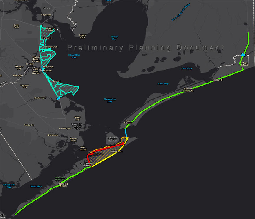
SNEAKING A PEEK AT THE BIG WALLS, BIG GATES ARMY CORPS COULD PROPOSE FOR THE COAST LATER THIS MONTH  On October 26, the agency will single out one of the 4 big proposals it’s been pondering for the Texas coast as the chosen one, reports the Texas Tribune’s Kiah Collier. One of them “calls for the construction of a 17-foot-high levee along the entirety of Galveston Island,” as well as Bolivar Peninsula. Ring any bells? It’s the so-called Ike Dike (also known as the “coastal spine”) that A&M scientists dreamed up about a decade ago in response to the disaster and hypothetically-even-worse disaster that could’ve occurred if Ike had struck 30 miles further west. Another defense against that doomsday scenario that could make it into the proposal: a giant gate structure adapted from Rice’s Jim Blackburn and Philip Bedient’s 2011 idea for a mechanism that’d close before storms to block surge. (They wanted to put it just upstream from the Fred Hartman Bridge; the Corps has number of different spots in mind.) All the plans in the running include a so-called ring levee around Galveston’s bay side to protect it from reverse storm surge, a helping of smaller levees and gates, upgrades to existing flood control structures, and ecosystem restoration projects geared toward creating natural floodwater-fighting barriers. [Texas Tribune; previously on Swamplot] Map indicating proposed Alternative A plan: U.S. Army Corps of Engineers
Tag: Bolivar Peninsula
THE POWER BALLS HAVE ARRIVED! Okay, fess up: Which one of you has been secretly transporting oil from the Deepwater Horizon gusher to our local beaches? The Coast Guard reported over the weekend that up to 5 gallons of dime- to ping-pong-ball-size tar balls collected from the surf along East Beach in Galveston and the Bolivar Peninsula’s Crystal Beach came from BP’s little offshore accident. But surely the little bugger-balls can’t have been trying to swim all the way back to headquarters? “[Coast Guard captain Marcus] Woodring said the condition of the tar balls didn’t look like they had drifted all the way from the Macondo well. They were ‘inconsistent with the weathering pattern that would be expected,’ he said. ‘To travel 400 miles is going to take a long time,’ during which the oil would be expected to break down. Officials were investigating whether the tar balls were from oil that clung to the hull of a ship passing through the BP oil slick or were from ballast water taken on by a ship in the oil slick zone and later dumped in Texas waters, Woodring said.” [Houston Chronicle]
GALVESTON TAR BALLS UNDISTURBED BY OIL SPILL “If oil from the spill reaches Texas, it will likely be in the form of tar balls, said Capt. Marcus Woodring, U.S. Coast Guard sector commander for Houston-Galveston. He said tar balls found along Texas shores so far have been analyzed and are not from the spill. Tar balls are common along the Gulf Coast because of minor oil spills and natural seepage, he said. As a precaution, floating barriers are already being placed in washout areas on the Bolivar Peninsula to protect the wetlands behind them, he said.” [Houston Chronicle]
Now that everyone’s feeling all nostalgic about Hurricane Ike, please enjoy the sweet and soothing sounds of this video, featuring newly released aerial footage taken over portions of Galveston Island and Bolivar Peninsula on September 20th, 2008.
- Aerial Survey Post Hurricane Ike [SSPEED]
Video: Bryan Carlile, Beck Geodetix
COMMENT OF THE DAY: A BOOST FOR THE BOLIVAR BUYOUT? “A large part of Bolivar is going to be turned into a nature preserve. FEMA is buying out many of the properties. . . . I suppose that buyout was made easier by the rate of foreclosures. . . .” [Raj, commenting on Where the Action Was: Houston Summer Foreclosure Map]

