05/12/17 3:45pm


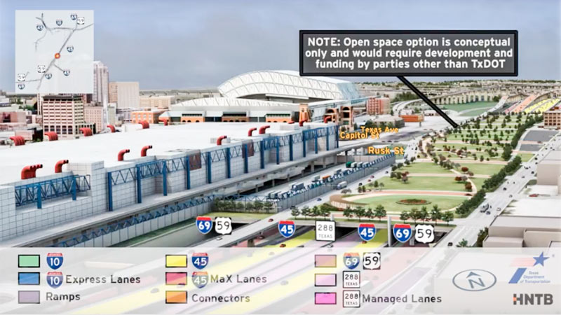
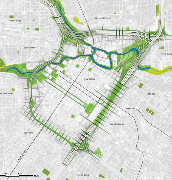
In between showing off various multicolored interchange tangles, the new flyover preview video of the huge changes proposed for I-45 North and the downtown freeway circuit glides viewers by a handful of areas where freeways will dive underground — while splicing in some new renderings of the tops of those tunnels-to-be as they could look, if somebody wanted to pay up to turn them into a park. (The animation is careful to emphasize once again that said parks would have to be developed and funded by a source other than TxDOT — and so far, there are no signs that anyone has stepped up.)

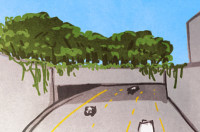
The rendering up top shows the would-be-parallel sections of 45, 59, and SH 288, running behind the convention district where 59 sits now — the whole bundle would be pulled down below flood grade and covered up, evidently with concrete if the park thing doesn’t work out. (A clip of just that section of the 10-minute animation is included above; a tiny rendered version of the Cheek Neal Coffee building can be spied along the edge of the freeway, though SEARCH Homeless Service’s new building one block north isn’t specifically drawn in next to it.)

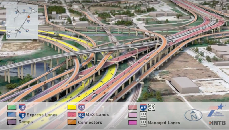
The video also gives the section of 59 from Main to San Jacinto streets the same burial and dressup treatment:

CONTINUE READING THIS STORY

Bridging the Gaps
05/12/17 1:30pm


Having trouble sifting through some of the massive freeway jumbles in the latest plans for that major I-45 reroute between Downtown and the Beltway? This new video (making the rounds this month as TxDOT hosts a set of public meetings to chat about the project) may or may not help you out. The 10-minute animation shows off what the project plans look like in multicolored, car-spangled 3D action, dragging viewers slowly along the entire project route from Spur 521 up to Beltway 8.

The project plans pull 45 over to the east side of Downtown, to line up alongside US 59 and dive underground behind the George R. Brown convention center. Various flavors of new express lanes, managed lanes, managed express lanes, and connectors weave into and out of a massive new 45-59-10 junction as shown above, all labeled by color. Here’s a clip of the above video showing just that section of the animation:

CONTINUE READING THIS STORY

Painted By Number
08/04/16 4:30pm

THE ODDS ON A PIERCE ELEVATED COMEDOWN Map of Proposed I-45 Rerouting, Downtown HoustonWriting in the latest issue of Texas Architect magazine — which is now debuting a redone website with a new web address and a new all-articles-are-now free policy — Ben Koush surveys the prospects for the raised section of I-45 now dividing Midtown from Downtown: “While there have been some plans floated around to convert the decommissioned section of the Pierce Elevated into Houston’s version of the Highline, most people I spoke with didn’t think that was going to happen, simply because TxDOT needs the money it could get from selling that right of way to private developers. Some still hold out hope that at least some of the land or maybe even a small section of the elevated roadway could be made into a public green space.” [Texas Architect; previously on Swamplot] Plan of “currently approved scheme” for I-45 rerouting around downtown, showing possible green space: SWA Group

03/21/16 2:45pm

COMMENT OF THE DAY: THOSE I-45 EXPRESS LANE PLANS ARE CUTE NOW BUT JUST WAIT UNTIL THEY GROW UP pierce-street-45-downtown“Fine with these updates, provided the Pierce [Elevated] still gets torn down. Express lanes might seem like a good idea, but they’ll most likely be hindered by limited ingress/egress and often shunpiked. I’d imagine they’ll also be pretty expensive owing to the proposed modifications to the design. It’s a good design if you’re trying to center transportation around private auto use, but at some point, that can’t be the primary design consideration anymore.” [TMR, commenting on What Happens When You Decide To Redo That Downtown Freeway Plan in Your Spare Time] Photo of Pierce Elevated: Russell Hancock

02/11/16 4:45pm

SOME HELPFUL TIPS FOR PLACING A PARK ON TOP OF AN UNDERGROUND FREEWAY Meanwhile, in Dallas: What goes into the equation to span a park across a multi-lane underground freeway tunnel, as TXDoT’s latest updates on the planned I-45 redo suggest might be possible? Planning for Klyde Warren Park, which covers an underground section of the Woodall Rogers Freeway between I-35 and I-45 at the edge of downtown Dallas, had to take into account everything from the weight of hundreds of thousands of feet of fill, potential damage to structural elements from root systems, anticipated visitor weight, and all the other little projects that private donors wanted to add. Project coordinators also faced mid-project fire code changes, limited freeway closure allowances for construction, and a $16.7-million funding shortfall that was eventually closed by 2009’s Recovery and Reinvestment Act. The park officially opened in 2012 with a concert headlined by Trombone Shorty and the Polyphonic Spree. [D Magazine, Klyde Warren Park]

02/11/16 1:30pm

COMMENT OF THE DAY: MAKING A U-TURN ON REROUTING I-45 I-45 and 59 Proposed Tunnel“I was for this reroute plan early on initially, but as time has gone by I’ve grown against it. This massive freeway is going to ruin an up-and-coming scene happening currently in EaDo, all for the sake of meshing Midtown/Downtown. The best alternative is to tunnel the Pierce underneath its current route. It’s the least destructive and will make all parties happiest I.M.O. And don’t give me this crap excuse that nothing can be underground here because of floods. If everything is supposedly so ‘big’ here in Texas, then please think bigger when it comes to this project.” [Eddie, commenting on TxDOT’s Plans for Freeway Expansion Around and Below the Newly Protected Cheek-Neal Coffee Building] Illustration: Lulu

02/10/16 5:00pm

I-45 Reroute and Greenspace Conceptual Plans from September 2015, Downtown, Houston, 77002

A dotted line runs right along the inside edge of the Cheek-Neal Coffee Company’s former roasting plant at 2017 Preston St. at the corner with St. Emanuel St., which was declared a protected city landmark today after starts to the building’s redevelopment by new owners last year.  The line marks the proposed right-of-way for TxDOT’s plans to reroute I-45 alongside 59 and send the Pierce Elevated out to pasture, as shown in update documents released in September. The 1917 building shows up as a beige box at the corner of Preston and St. Emanuel in the above capture from the project’s interactive online map system, and the seafoam green highlighting to the left indicates the newly planned frontage roads that would run to the west of it.

But the Cheek-Neal building itself actually doesn’t appear to be on the chopping block. The blue highlighting indicating the future path of freeway lanes skirt the western edge of the structure (though they appear to engulf the Loaves and Fishes soup kitchen across Congress St. to the north). Moreover, a cross-section through the I-45-59 bundle specifically shows the building in place, with the frontage road to the east and the freeways tucked out of sight below ground level:

CONTINUE READING THIS STORY

Preservation on Preston
05/01/15 11:15am

If you were dazzled by the wide swaths of concrete laneage and complicated color-coded spaghetti interchange entanglements in the TxDOT renderings released last week — but had trouble comprehending the massive scale of the proposed reroute of I-45 around Downtown — you’ll want to try this second go at it. The state transportation agency has now produced a video version of its freeway-rewrapping proposal, complete with tiny little animated cars and trucks moving along 3-D representations of those new wide surfaces. It’s so mesmerizing, many viewers may not even notice what happened to the Pierce Elevated.

Video: TxDOT, via Houston Chronicle

North Freeway Downtown Rewrap
04/23/15 5:30pm

Proposed Changes to I-45, I-10, and I-69, Houston

There’s so much to talk about and gawk at in the latest “proposed recommended alternatives” for reshaping I-45 now being shopped around by TxDOT and a host of freeway-happy consultants — enough for a fourth round of public meetings scheduled for tonight and next week, plus hours of extra-curricular speculation. The plans encompass dramatic changes to the North Freeway all the way from Beltway 8 to a new split adjacent to the Third Ward, including eye-opening widenings, all sorts of exciting tunnels and high-flying overpasses, a slew of spaghetti-like interchanges, and — the pièce de résistance — the wholesale give-up of I-45’s current L-shaped wrap around Downtown, including the Pierce Elevated.

These 5 images from our highway overlords’ exciting imagined future sum it up best:

1. The X-ing-out of the Pierce Elevated (diagrammed above). If the elevated portion of I-45 along the path of Pierce St. goes away, how will anyone be able to tell where Downtown ends and Midtown begins? Don’t worry, a few proposals are being shopped around to turn a de-automobiled structure into a High Line—like public park or bikeway. (Though much bigger, ′cuz Houston.)

CONTINUE READING THIS STORY

Freeway Frenzy!
09/13/13 11:00am

HIGHLY VISIBLE BILLBOARD REMINDS HOUSTON DRIVERS OF THE INVISIBILITY OF HOMELESSNESS You can’t miss it: Just south of Downtown, this pristine billboard went up recently above the northbound feeder of I-45. Its lonesome assertion, “Even the pigeons don’t see me,” is attributed to the “voice of the homeless.” What gives? Glasstire’s Paula Newton explains: “[I]t’s meant to raise awareness about homelessness. The billboard is a project by artist Jessica Crute in conjunction with a group show at Deborah Colton Gallery called Collective Identity. Crute [is] president and founder of a young non-profit organization Voice of the Homeless.” [Glasstire] Photo: Glasstire