
- 15807 Seven Springs Dr. [HAR]
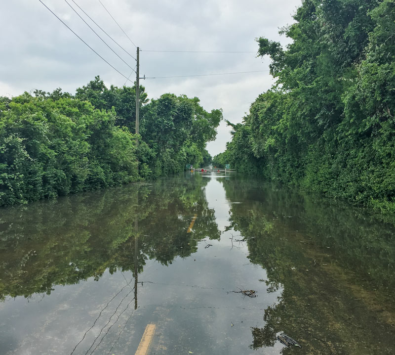
A reader caught the view above during a lunchtime bike ride into the Barker reservoir yesterday. The shot shows the nearly submerged stop signs on the currently-closed road barricade where Barker Clodine Rd. merges into the hike-and-bike trail system running throughout much of the reservoir (which stretches between I-10 and the Westpark Tollway just west of Hwy. 6). The Corps of Engineers has been releasing water from both Barker dam and its sister reservoir Addicks across I-10 since Thursday — but the level behind the dams continued to rise for a few days as additional water drained into the basins from the surrounding watersheds, faster than that water could be safely released downstream into Buffalo Bayou.
Both Barker and Addicks reservoirs’ levels finally began dropping on Saturday — though both started filling again briefly on Sunday as water from later-in-the-week storms trickled east from the surrounding watersheds. Below is an up-to-date look at Barker reservoir’s change in storage since the Tax Day flood, per USGS measurements:
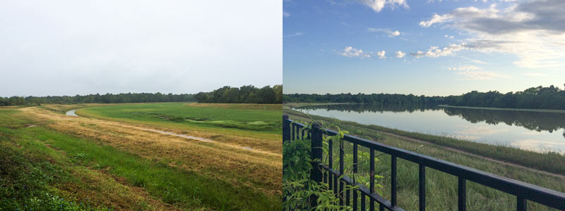
A water-watching reader sends some south-facing photos from yesterday evening (right) and last October, comparing views over the fenceline of the 400-ft.-wide diversion channel at the northern edge of the Addicks reservoir. The channel picks up most of the flow from Langham and Horsepen creeks where they join up as they flow south into Addicks. The 400-ft.-wide floodway was dug in the 1980s; the flow usually lurks down in the narrow channel seen in the shot on the left.
The scene above is less than a mile east of Bear Creek Village, where water is now moseying into neighborhoods from the western edge of the reservoir (and washing some wildife and livestock around). The Army Corps of Engineers has been releasing water from both Addicks and Barker dams to minimize the pooling (and relieve stress on the dam structures themselves) — but those releases have to be done slowly enough to avoid causing additional flooding downstream along Buffalo Bayou. Meanwhile, water is still flowing into the reservoirs from western watersheds; the measured levels behind the 2 dams topped all previous water level records and normally allowed pooling limits in the reservoir by Tuesday, and has been rising since. Here’s a shot of water gushing out through some of the gates of the Barker dam this afternoon:
The Army Corps of Engineers will begin releasing water from the Addicks and Barker dams later this evening; nonetheless, water levels in the reservoirs are still expected to rise high enough to cause street flooding in the Bear Creek subdivision north of Clay Rd. The Corps also notes that nearby residential areas should anticipate that wildlife inhabiting approximately 26,000 acres of forested land in the 2 reservoirs may flee the rising water and enter nearby neighborhoods. That wildlife may include the feral pigs previously targeted by Harris County Precinct 3’s trapping-and-foodbanking program; sightings of animals such as deer, coyotes, and bobcats have also been reported in the reservoirs.
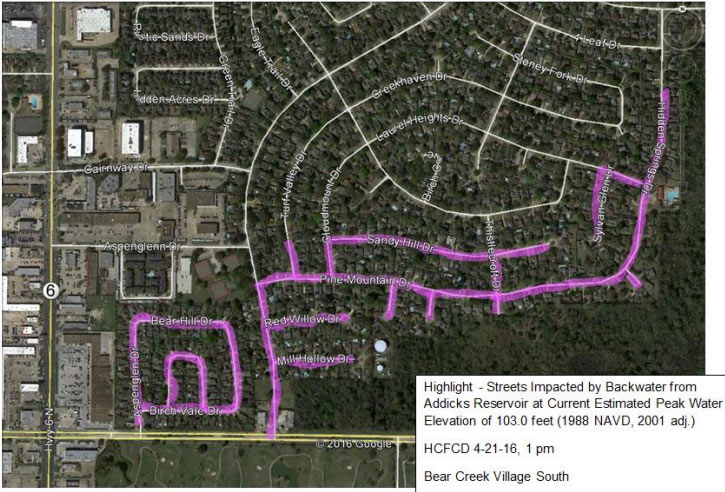
Harris County Flood Control District has published a list of streets that could be impassible for days or weeks due to flooding, as well as a few maps (one of which is shown above). Here’s the other map below, highlighting in pink the streets south of Addicks Satsuma Rd. and Langham Creek expected to get water when the level in Addicks reaches 103 feet:

FLOODING REPORT FROM THE NORTHWEST HOUSTON PRAIRIE BOWL The worst flooding damage from those late April storms centered around a swath of Highway 6 stretching from the Katy Freeway to 290 in northwest Houston. The heaviest rainfall was centered further west, along the planned path of the Grand Parkway Segment E. “[Jennifer] Bayles said her section of Bear Creek Village wasn’t within the 100-year flood plain when she and her husband bought their house 17 years ago. But it was added to the flood plain in new maps developed after Tropical Storm Allison in 2001, and the couple purchased flood insurance despite the steep premiums. ‘We’re well-insured; we’ll be fine,’ she said, but some neighbors don’t have the coverage they need. And their recovery efforts grew more complicated when they learned that if their homes sustained sufficient damage they would have to elevate when they rebuild. In the past few years, Bayles said, her street has flooded regularly during heavy rains, stranding residents in their homes for hours. But the April thunderstorms were the first time she’s had water in her house, she said.” [Houston Chronicle]


