COMMENT OF THE DAY: FOLLOW THE SMOG 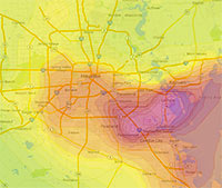 “You do not escape smog in Houston by moving to the burbs. In the summer, Houston has a circular wind pattern that takes ship channel pollutants for a ride out to the suburbs. Go to the Houston Clean Air Network website and set the animation for Aug. 6, 2012. You will see a big area of ozone form over the ship channel that gets blown out to Pearland, then Sugar Land and spends the late afternoon in Cinco Ranch and just east of Katy before starting to drift back east. The worst of the smog slides south of the City and never really gets north of I-10 inside the loop. Ship channel industries account for about 2/3rds of the smog. The rest is motor vehicle emissions. Ship channel industries have made significant progress in reducing and controlling emissions. But more sprawl and more traffic threaten to offset the progress made on the ship channel. Thus, the smog issue is a very real consequence of sprawl that is not escaped by sprawl either.” [Old School, commenting on Holding Back on That Downtown Hotel Push; The Beer Garden, Greenhouse, and Food Court Growing in Prohibition’s Basement] Image: Houston Clean Air Network
Sign up for the Newsletter
Pollution

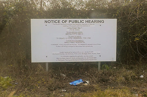
Signs have gone up around the former metal foundry site at 3617 Baer St. in the Fifth Ward indicating that a hearing is scheduled for this Thursday to get city approval for the latest rejiggering of homesites on the 35-acre tract. Developer Frank Liu of Lovett Homes, InTown Homes, and a few other local builder brands plans to put a total of 538 homes (down from 589) on the EPA-monitored property, known as the MDI Superfund Site after the last owner of the metal-casting operations, Many Diversified Interests, which shut down in the early 1990s (previously, the plants were owned by TESCO). The property, which lies just south of I-10 about 2 miles of east of downtown, was listed on the EPA’s list of priority Superfund sites in 1999, after tests showed the soil and groundwater was contaminated with lead and other hazardous metals.
Living Green

COMMENT OF THE DAY: WHY IS ANYONE LIVING THAT CLOSE TO A REFINERY?  “Tax policy should probably discourage residential habitation in neighborhoods near the Houston Ship Channel and encourage people to move away from them. As such, giving existing residents or residential property owners a tax cut in order to reward them for residing there or maintaining and leasing housing to other people would be extraordinarily counterproductive and stupid.
Manchester in particular is a neighborhood where the City or State government should seriously consider its options with respect to eminent domain. There’s nothing quite like it anywhere else in the region. Even the furthest north residential bits and pieces of Pasadena are better isolated from refinery activities and more integrated into their city than is Manchester.” [TheNiche, commenting on Baytown Buc-ee’s Is Here; Goodbye Mission Burrito, Hello Ãœberrito Mexican Grill] Illustration: Lulu
“Tax policy should probably discourage residential habitation in neighborhoods near the Houston Ship Channel and encourage people to move away from them. As such, giving existing residents or residential property owners a tax cut in order to reward them for residing there or maintaining and leasing housing to other people would be extraordinarily counterproductive and stupid.
Manchester in particular is a neighborhood where the City or State government should seriously consider its options with respect to eminent domain. There’s nothing quite like it anywhere else in the region. Even the furthest north residential bits and pieces of Pasadena are better isolated from refinery activities and more integrated into their city than is Manchester.” [TheNiche, commenting on Baytown Buc-ee’s Is Here; Goodbye Mission Burrito, Hello Ãœberrito Mexican Grill] Illustration: Lulu

Inspired by reading René Steinke’s new and recently optioned-for-film novel Friendswood, the plot of which centers on the aftermath of the Brio Superfund mess just south of I-45 and the Beltway, Cite magazine’s Allyn West returns to the former chemical waste facility at Dixie Farm Rd. and Beamer Rd. to snap some photos and have a look around: “The first thing you pass is a landfill. And then, incongruously, you pass archetypal subdivisions with bucolic names, much like Southbend must have been. There’s a dedicated bike lane on both sides of Dixie Farm, clearly marked and freshly painted. Then turning toward the site onto Blackhawk Boulevard, you pass Ashley Pointe, a new subdivision. That morning, I saw construction workers milling about around unfinished stick frames. If Southbend still existed, Ashley Pointe would sit right next to it.”
Buried Secrets

A LOOK AT SOME OF THE LIQUID POO FLOWING ONTO COLQUITT ST. IN MONTROSE 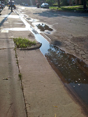 A reader wants to be sure Swamplot readers are alerted — as city inspectors, the HPD’s environmental division, and the property manager have already been, the reader says — to the “recurring” problem of raw sewage flowing out from the Takara-So Apartments at 1919 W. Main St. and into neighboring storm drains. The photo at left, taken on Monday, shows the sewage (“you can smell it”) along Colquitt St., pausing for a bit of sun on its way to lower-lying bayous and waterways. [Previously on Swamplot] Photo: Swamplot inbox

COMMENT OF THE DAY: POLLUTION CREDITORS  “It’s good to see that the Feds will help clean up the CES Environmental Services site. I’m of the opinion that bankruptcy law should be revised to require that environmental clean-up be paid for before creditors can be paid. It would help in cases like this, but it would also make lenders push dirty industries to clean up their act. Companies with bad environmental records would feel it in their ability to get credit.” [ZAW, commenting on Predicting Houston Real Estate Hotspots; Drinking Water from Lake Conroe] Illustration: Lulu

 From a top-floor perch in their tiny, handcrafted, award-winning live-work compound at 5910 Grace Ln. (featured a while back in Dwell magazine), architect Mark Schatz and designer Anne Eamon had front-row seats to the ongoing smelly, toxic, and deadly shitshow that marked the over-the-back-fence tenure of CES Environmental Services, in its facility at 4904 Griggs Rd., just a mile and a half south of the UH campus. Among the joys they were able to plug their noses and record was this tableau from July 2009: “In the first photograph [Schatz] took of the scene unfolding below him, shot like all the rest with the eye of an architect, perfectly framing the site, the tank farm is to the left, and a worker races from the right to the warehouse, which has a smoking hole blown through the roof. In a subsequent photo, oxygen tanks are wheeled in. Then the oxygen tanks fall over. Then a forklift shows up, and a crew starts setting the oxygen tanks upright. All this time, while they go through this Three Stooges routine, their co-worker is lying inside the warehouse covered in burns. You can see the back of a metal cylindrical tanker truck in the photos. [Schatz and Eamon] learn later that the fatally burned worker had opened the hatch on the tanker and switched on his flashlight to peer in. A spark from the flashlight set off a flash fire.”
Toxics by Design

A spokesman says the Houston Police Department has “long been aware” of most of the 127 vehicles Texas Equusearch found submerged in Houston bayous back in 2011, when the nonprofit search-and-rescue organization used a sonar-equipped boat to hunt for the rented car of an elderly woman who had gone missing. But until Equusearch went public with the data this week, it appears no one from law enforcement had bothered to bring the rusting cars and trucks to the attention of environmental organizations, families of missing persons, wrecker drivers, classic-car collectors and restorers, bayou boaters, noodlers, or other groups that might have wanted to know.
No matter, now: Above, courtesy of Texas Equusearch and the Houston Chronicle, is an interactive map identifying the coordinates and descriptions of the vehicles — including at least one full big rig — that have been gently rusting at or near the bottom of Brays and Sims Bayous for at least 2 and a half years. The Chronicle data appears to exclude the half-dozen or so transportation options Equusearch searchers found beneath the waters of the relatively un-trafficked Buffalo Bayou. But you can spot some of them in the upper portion of this screen capture published with Joel Eisenbaum’s original report for KPRC of a similar map:
Submerged Bayou Secrets

COMMENT OF THE DAY: WHAT HOUSTON SMELLS LIKE  “Ahhhh . . . the eau du Houston: a heady combination of ground level ozone, sewer methane, burnt coffee aroma (when the breeze/wind is blowing from EaDo), combined with various other odoeurs ranging from the slightly offensive to the occasional sweet smell of some heavily perfumed flower/tree/shrub . . .” [Patrick, commenting on The Sweet Smell of Houston History] Illustration: Lulu

WHERE THE POOP IS, IN AND AROUND LAKE HOUSTON  “While some Houston bayous, such as Buffalo and White Oak, have bacteria levels seven times higher than Lake Houston’s watershed, the waters flowing from the San Jacinto River are more vital, said Steve Hupp, Bayou Preservation Association spokesman. . . . Houston’s drinking water is pumped from an area of the lake not contaminated with bacteria.
Only the northwest corner of the lake is impaired, records show. This segment runs from where the river intersects Spring Creek, winds through Humble and past the Kingwood golf course, and ends at the West Lake Houston Parkway bridge.
The bacteria level found in the lake segment exceeds the state standard of 126 E. coli per 100 milliliters of water by 100 percent. Levels on both the river’s west or east forks are lower — exceeding the standard by 25 percent to 56 percent, depending on the segment. Yet a small tributary, Crystal Creek, which feeds into the west fork, has the highest count. It exceeds the state standard by 168 percent.
The communities along the San Jacinto watershed are experiencing a boom in development, especially around the river’s west fork in Montgomery County. Exxon Mobil already has a new 385-acre corporate campus that will be home to 10,000 workers under construction there, while the Boy Scouts recently sold their nearby 2,175-acre camp to a master-planned community developer for a reported $60 million.” [Houston Chronicle ($)] Photo of Lake Houston: Sara Robertson (license)
“While some Houston bayous, such as Buffalo and White Oak, have bacteria levels seven times higher than Lake Houston’s watershed, the waters flowing from the San Jacinto River are more vital, said Steve Hupp, Bayou Preservation Association spokesman. . . . Houston’s drinking water is pumped from an area of the lake not contaminated with bacteria.
Only the northwest corner of the lake is impaired, records show. This segment runs from where the river intersects Spring Creek, winds through Humble and past the Kingwood golf course, and ends at the West Lake Houston Parkway bridge.
The bacteria level found in the lake segment exceeds the state standard of 126 E. coli per 100 milliliters of water by 100 percent. Levels on both the river’s west or east forks are lower — exceeding the standard by 25 percent to 56 percent, depending on the segment. Yet a small tributary, Crystal Creek, which feeds into the west fork, has the highest count. It exceeds the state standard by 168 percent.
The communities along the San Jacinto watershed are experiencing a boom in development, especially around the river’s west fork in Montgomery County. Exxon Mobil already has a new 385-acre corporate campus that will be home to 10,000 workers under construction there, while the Boy Scouts recently sold their nearby 2,175-acre camp to a master-planned community developer for a reported $60 million.” [Houston Chronicle ($)] Photo of Lake Houston: Sara Robertson (license)

COMMENT OF THE DAY: WHAT’S IN YOUR AIR  “There are three big air quality concerns for Houstonians: toxics, smog and particulates. Living in the East End puts you on the front line for toxic emissions. Toxics tend to be heavier than air and do not travel very far from where they are released. Milby Park had almost off the chart levels of Butadiene 1,3 back in mid 2000 due to problems at the Texas Petrochem plant next door. That problem was fixed and levels have come way down. But, if there is a release or a leak that is sending off toxics, the East End gets the best whiff. On days where there is little wind, the East End is also the spot most likely to get smog (NOx+SOx+sun=ozone). If there is good circulation in the atmosphere, Pearland to Sugar Land can see pretty bad smog, especially with the old coal plant in Sugar Land. But so can everywhere from Memorial Park up to the Woodlands. Houston’s smog has improved dramatically thanks to some good work by regulators and industry in identifying and going after the highly reactive stuff that really drives ozone production. But Houston is still in the top ten nationally when it comes to ozone. . . . Particulates are not as big a concern in Houston as we do not have much steel or other industries that are heavy on particulates, but we are still just over the new Federal standard of 12 parts per somethingerother. The particulates on the East End are generally higher than in other parts of town due to all the industry in the area. The air quality on the east side is definitely worse than on the west side. But ozone (smog) can visit just about anyone in the Houston area.” [Old School, commenting on Comment of the Day: The Limits of Eastward Development] Illustration: Lulu

COMMENT OF THE DAY: THE LIMITS OF EASTWARD DEVELOPMENT  “With every mile moving east, you are getting nearer to Houston’s gigantic petrochemical industrial complex, along with its unpredictable environmental and public health issues, which begin just about a mile east of Eastwood (for example, look at the location of identified Superfund Sites in Harris County, . . . which gives a clear picture). This is the main reason why people in Houston, and those who can afford it, stay as much west as possible. . . . ” [Larry, commenting on Comment of the Day: What’s the Scoop on Eastwood?] Illustration: Lulu

W. A. PARISH PLANT ONE OF THE WORST POLLUTERS IN THE COUNTRY, FINDS REPORT  According to a new study published by Environment America, NRG Energy’s coal-firing W. A. Parish Electric Generating Plant, on Smithers Lake outside of Richmond, is really good at being dirty. Though the plant has been messing around with a way to clean itself up in the past year or so, the report, published today, still fingers it as the 5th dirtiest in the country when it comes to carbon emissions. And here, in order, are 1-4: “Georgia Power Co.’s Plant Scherer, Alabama Power Co.’s James H. Miller Jr. Plant, Luminant’s Martin Lake in Texas, [and] Ameren’s Labadie in Missouri.” [StateImpact; Environment America; previously on Swamplot] Photo: Flickr user Joe A.

HOW HOUSTON’S AIR GOT BETTER  During the past decade, Houston’s notoriously polluted air has become — well, if not quite good, then not quite as bad, says NPR’s Richard Harris. (Pay no attention to what that ozone app may or may not tell you.) How? Well, it seems that pollution regulators in the early aughts had been worrying about all the wrong gases: “They were going all-in against [only] one of the pollutants that create smog, while downplaying the role of other emissions from the petrochemical plants,” reports Harris. “Barges carting chemicals up and down the [Ship Channel] were leaking. . . . And some types of storage tanks were leaking as well. . . . It turns out that routine day-to-day emissions were not the biggest problem.” Since then, regulations targeting those chemicals, like ethylene — as well as the use of infrared cameras that can spot them — appear to have made a difference: Port of Houston Authority employee Dana Blume tells Harris: “I can look out of my office window now and almost every single day see downtown.” [NPR; previously on Swamplot] Photo: Flickr user stmu_mike

NOW ON YOUR MOBILE DEVICE: WHY YOU CAN’T BREATHE  A team comprising researchers at UH, Air Alliance Houston, and the American Lung Association have launched OzoneMap, an app that “monitors chemical weather,” reports John Metcalfe of The Atlantic blog Cities. And whether the app helps explain your coughing fit or alerts you to the chance of a really pretty toxic sunset, the best part is that it’s only available in Houston! And why Houston, of all places? Besides the industrial flares, that is? Here’s Metcalfe: “The Houston/Baytown/Huntsville region comes in eighth place for most ozone-polluted cities in America, as ranked by the American Lung Association. Persistently sunny weather, a battalion of petrochemical facilities and scads of fuming cars on the road make Houston a nightmare for anyone who’s chemically sensitive. For these folks, walking outside is like playing a lower-stakes version of Russian roulette, with 30 to 40 days of the year fogged with hazardous levels of ozone.” [Cities; previously on Swamplot] Map: Cities
