COMMENT OF THE DAY: NO NEED FOR A TRAIN ON I-10 WHEN YOU CAN JUST PARK-AND-BUS  “. . . The train isn’t going to travel that much faster than buses, if at all. Also, buses in the Katy corridor make just one stop at most between the burbs and Downtown (the major route is express from the Park-and-Ride lot direct to Downtown). And people play on their phones on the bus (have you never been on one? the park-and-ride vehicles have nice cushy seats and baggage racks). And unless one’s destination is outside the CBD, no transfers are required; you are likely dropped off within a few blocks of your destination, an easy walk. Furthermore, on the highly used Park-and-Ride routes the buses leave every several minutes; you don’t have to time your arrival, the wait time to depart is minimal. Commuter rail never works like that (though light rail can).
The assumption that rail is going to provide superior service simply isn’t true. In fact, it’s likely to be worse service for the patrons than what we have now with the Park-and-Ride buses. Especially since most everyone will have to drive to the station anyway, so no difference there.” [Local Planner, commenting on Was It a Good Idea To Derail I-10?] Photo: Energy Corridor
“. . . The train isn’t going to travel that much faster than buses, if at all. Also, buses in the Katy corridor make just one stop at most between the burbs and Downtown (the major route is express from the Park-and-Ride lot direct to Downtown). And people play on their phones on the bus (have you never been on one? the park-and-ride vehicles have nice cushy seats and baggage racks). And unless one’s destination is outside the CBD, no transfers are required; you are likely dropped off within a few blocks of your destination, an easy walk. Furthermore, on the highly used Park-and-Ride routes the buses leave every several minutes; you don’t have to time your arrival, the wait time to depart is minimal. Commuter rail never works like that (though light rail can).
The assumption that rail is going to provide superior service simply isn’t true. In fact, it’s likely to be worse service for the patrons than what we have now with the Park-and-Ride buses. Especially since most everyone will have to drive to the station anyway, so no difference there.” [Local Planner, commenting on Was It a Good Idea To Derail I-10?] Photo: Energy Corridor
Sign up for the Newsletter
Public Transportation

THE RIDE TO THE BULLET TRAIN AT NORTHWEST MALL  One piece of the agreement announced by Mayor Turner this morning with Texas Central Partners, the company behind a planned bullet train between here and Dallas: a promise that the city and the company will work together on transit options to and from the train’s Houston station. “In the memorandum,” Dug Begley reports, “Texas Central notes the likely end of their Houston-to-Dallas line will be south of U.S. 290, west of Loop 610 and north of Interstate 10. The exact site has been long suspected as the current location of Northwest Mall.” All but a handful of stores inside the mall shut down earlier this year. [Houston Chronicle ($); previously on Swamplot] Photo of Northwest Mall: Levcor

STARTING IN JULY, YOU’LL ONLY NEED 2 BUS RIDES TO GET TO GALVESTON  Since 2013, when the last regular bus service was canceled, taking a trip from Houston to Galveston on public transportation has been a bit of a challenge: It might take you 1 light-rail train ride, 4 buses, a 3-mile walk, and 4 hours. Thanks to a 2-year grant from TXDoT, support from Galveston County and Texas City, and an approval by Houston’s Metro Board today, it’s about to get a whole lot easier. Beginning July 10th, an Island Express route coordinated by the 2 cities’ transportation agencies will allow weekday service between the Downtown Transit Center in Houston and Island Transit’s Downtown Transit Terminal at 25th St. and the Strand in Galveston 3 times a day — with a transfer at the Bay Area Park & Ride — for $9. There’ll be a stop in Texas City, and bikes can ride too. Metro expects about 20 riders a day to use the service. [OffCite; Christof Spieler] Draft schedule for Island Express: Metro

HOUSTON LIGHT RAIL BEATS THE COMPETITION IN PEDESTRIAN, BICYCLE COLLISIONS PER MILE 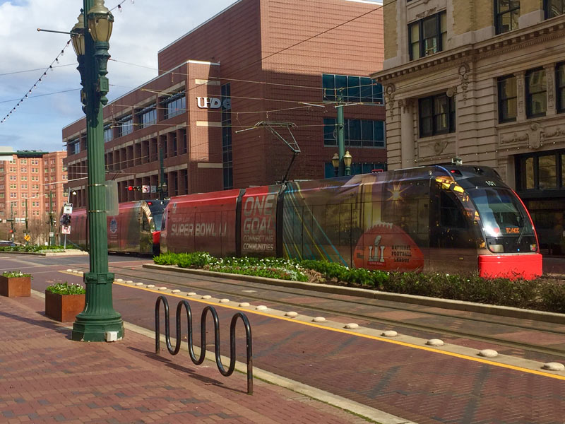 Following 2 deaths over the course of Super Bowl Week and Weekend resulting from cyclist-vs-light-rail collisions, the Chronicle‘s Dug Begley takes a look at how Houston stacks up nationally in terms of train-related accidents. The verdict, after a look through some National Transit Database data: Houston’s rail system has more walker and cyclist hits per mile “than any other major line in the country.” Houston breezes in at less that 100,000 train miles travelled per collision (compared to more than twice as many miles traveled per collision in Dallas, and more than 17 times as many in Boston). Metro CEO Tom Lambert tells Begley it may have to do with Houston’s high number of at-grade crossings and relative lack of barriers to keep people off the tracks. Begley says that the original decision to build the train at-grade isn’t itself unusual given the cost of elevated rail, but notes that “few places outside Houston have built their lines in some of the most congested and pedestrian-heavy areas of their respective urban regions.” [Houston Chronicle; previously on Swamplot] Photo of light-rail train dressed for Super Bowl Week: Christine Wilson

COMMENT OF THE DAY: WHY ISN’T LONG AND SKINNY ALWAYS OUT OF STYLE?  “Maybe it is just me, but I feel like the folks that are for the high speed rail are the same people that are against the Dakota pipeline. The HSR will undoubtedly have large environmental concerns for the state.” [Bocepheus, commenting on High Speed Rail Case Heads to Trial] Illustration: Lulu

FINDING THE RIGHT WORDS TO TALK THROUGH HOUSTON’S RELATIONSHIP WITH SIDEWALKS  Taking together a recent rash of of essays complaining about Houston’s walkability, public transit, and sidewalk situation, Joe Cortwright over at City Observatory offers some thoughts on why it might be harder for city planners to buff up the city’s walking infrastructure than focus on its car standards: planners, both locally and nation-wide, don’t have as many ways to measure unpleasant walking experiences, or sufficient language to describe them. Cortwright writes that the anecdotes and narratives put forth by Houston’s frustrated would-be walkers are “rich and compelling in their detail, but lack the technocratic throw-weight of quantifiable statistics or industry standards to drive different policies and investments in our current planning system. [ . . . But] this isn’t simply a matter of somehow instrumenting bike riders and pedestrians with GPS and communication devices so they are as tech-enabled as vehicles. An exacting count of existing patterns of activity will only further enshrine a status quo where cars are dominant. For example, perfectly instrumented count of pedestrians, bicycles, cars in Houston would show — correctly — little to no bike or pedestrian activity. And no amount of calculation of vehicle flows will reveal whether a city is providing a high quality of life for its residents, much less meeting their desires for the kinds of places they really want to live in.” [City Observatory] Photo: Flickr userbpawlik

LAND PURCHASES BEGINNING ALONG PROPOSED HOUSTON-TO-DALLAS BULLET TRAIN ROUTE 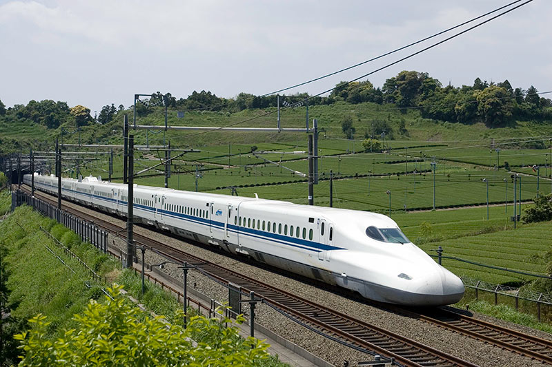 Texas Central Railway’s CEO tells Realty News Report’s Ralph Bivins that owners of some properties in the projected path of the planned Houston-to-Dallas 200mph rail line have already agreed to sell their land to the company, which is hoping to get started on construction of the 90-minute route next year. Tim B. Keith says he’s “encouraged with the progress” of what he refers to as the project’s “voluntary land purchase program.” He notes that “Texas’ Constitution and state statutes have long granted eminent domain authority to railroads such as Texas Central, as well as pipeline companies, electric power companies and other industries,” but calls eminent domain “a last resort.” The line’s Houston station is now planned for “the area along the 610 Loop between 290 and I-10″ after a Federal Railroad Administration review rejected the idea of a Downtown stop because of projected high costs and environmental impacts. [Realty News Report; Houston Public Media; previously on Swamplot] Photo of Tokaido Shinkansen Tokyo-Osaka line: Texas Central Railway

In response to word from the Chronicle‘s Dug Begley this week that the Red Line’s Reliant Park light-rail stop might get its station name updated to an even older name, a Swamplot reader jumps on the case with a system-wide list of potential station name changes that might remain unaffected by the sale, rebranding, or demise of any nearby venues or landmarks. Begley notes it could cost Metro around $486,000 to change the Reliant Park stop’s signage. The agency says it would prefer to make the switch at the same time as 2 other station name changes currently under consideration (if they’re approved) — but not until after the Super Bowl, for which a set of cheaper temporary stickers will be deployed to help visitors find NRG Stadium.
The reader, in the spirit of Houston’s budding redesign-it-yourself urban planning scene, suggests that paying up now to swap out all the names that might become a problem later might actually be a long-term cost-saver. The proposed scheme makes sure every station name mentions a cross-street (or maybe a bayou), and keeps some references to existing transit centers, parks, or neighborhoods.
Here’s the full list of suggested switch-outs, separated by rail line, with the current names on the left:
What’s In a Name

WOODLAND HEIGHTS BUS MAPPERS TO METRO: YOUR NEW ROUTE PLAN MISSES THE TARGET 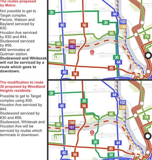 Metro says it’ll be ready to go with its new bus network on August 16, but that hasn’t prevented various groups from petitioning the transit agency to make late adjustments to its route map. One group of Woodland Heights residents is trying to get the new 30 route, which late in the process was shifted east to parallel the new 44 route down Houston Ave into Downtown, shifted west to Watson, Taylor, and Sawyer streets between Pecore and Memorial Dr. before entering Downtown from the west. The current proposed alignment leaves the Sawyer Heights shopping center and its Target without a bus stop. [Not of It] Diagram: Philip Teague

METRO KEEPING NEW BUS ROUTES UNDER WRAPS UNTIL AUGUST 16 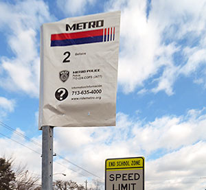 Every route sign at every bus stop in Metro’s service area should now have a plastic bag over its head, the transit agency says. Printed on those bags: the same old bus route numbers that’ve always been there, along with a couple of helpful phone numbers. Info on how the route will be changed come late summer should appear on vertical add-on signs lower on each pole. The great citywide bus-stop-sign unbagging (revealing the sign makeovers hidden underneath) is scheduled to take place just before August 16, the day Metro’s revamped route network debuts. [Metro; previously on Swamplot] Photo: Metro

SAVING UPTOWN, HOUSTON’S MASTERPIECE, FROM THE SCOURGE OF DEDICATED BUS LANES 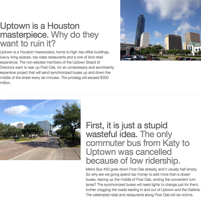 The Uptown Property and Business Owners Coalition is out today with a new website (portrayed here) meant to drum up opposition to the Uptown District and Metro’s plans to install dedicated bus lanes down Post Oak Blvd. The lanes, the last vestige of what was once a plan for an Uptown light rail line, would run from dedicated bus lanes linking to the Northwest Transit Center all the way to the proposed Bellaire/Uptown Transit Center near U.S. 59 and Westpark, where they might someday intersect with a University Line traveling eastward from that point. But the team behind the website wants none of it: “Uptown is a Houston masterpiece. Why do they want to ruin it?” reads the copy on the home page. Meanwhile, an introductory blog post on the site encourages readers to attend a friendly “town hall” meeting, tomorrow night at the Uptown Hilton, in the company of “hundreds of angry business owners and Uptown area residents.” [Save Uptown; previously on Swamplot]

THE MCCONAUGHEY IS STRONG IN THIS ONE A mere 6 months after Jim Carrey, Metro is out with its own riff on last year’s series of commercials for the Lincoln MKC emceed by a dusk-cruising Matthew McConaughey. But there’s no Texas Longhorn blocking the road for Metro’s version (above), meant to uh . . . re-introduce the transit agency’s newly reimagined bus service, scheduled to kick off in 4 months. Mixed into the atmospherics is a bus driver’s subtle diss of folks’ reliance on some of the old, less popular routes axed in the bus-map redo: “Where’re you really going on the road less traveled? Probably nowhere really great.” [Metro] Video: Metro

LATE MAY OPENINGS FOR SOUTHEAST AND EAST END RAIL LINES 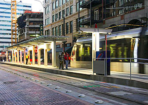 An official opening date has finally been set for Houston’s 2 new light-rail lines — and it’ll be later than the expected early-April debut. The East End and Southeast Lines will both open May 23rd, the Metro board announced this morning. [Houston Metro on Twitter; previously on Swamplot] Photo of new Central Station downtown: Metro

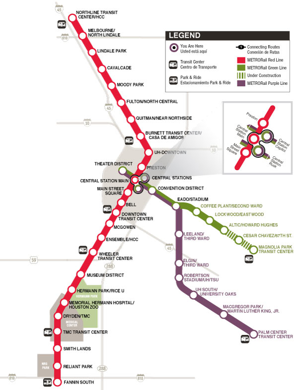
After a year and a half of redrawing, presenting, and tweaking, Metro’s “reimagined” transit plan was approved by the transportation agency’s board today. The interactive map above shows the whole system in all its reconfigured glory, including the new rail lines currently scheduled to begin running in April. Bus routes will switch over to the above route system in August.
All Approved for August

TXDOT LIKELY TO CUT FUNDING FOR WEST LOOP BUS LANES, SHIP MONEY SOUTH 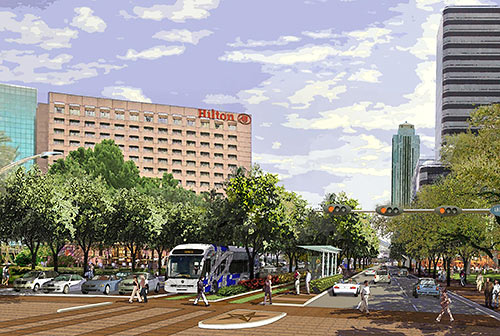 In a move that could spell doom for the Post Oak Bus Rapid Transit project, TxDOT’s planning director said Thursday that his agency is now recommending it ax a $25 million commitment to expanding connecting bus service along the West Loop. The plan called for elevated bus lanes  running along 610 from Post Oak Blvd. to the Northwest Transit Center near the Katy Fwy. and 610. The agency now claims that the $25 million would be better spent on an improved Texas 288–Beltway 8 interchange. [The Highwayman, previously on Swamplot] Rendering: Uptown HoustonÂ
