COMMENT OF THE DAY: TURNING HOUSTON INSIDE OUT  “It might be that the best outcome for Houston is for the Inner Loop to have an exurban quality of life. Send commuter rail out to the suburbs — not for the suburbanites to commute to downtown — but for the Inner Loopers to commute outbound in the mornings to densely clustered (out of necessity) suburban tall office towers surrounding the stations, and then back into town in the evenings.
This is more viable than the traditional idea of New Urbanist suburbs with transit connecting them to a downtown core since politically none of Houston’s suburbs are on board with cultivating a small town ambience, but are ok with letting office builders do their thing.
To be sure, suburbanites would still commute to downtown but it will be seen as an aberration. Downtown will still have things to do after dark, but other areas of the Inner Loop, connected by LRT/buses/cars/bikes/sidewalks, will do a much better job of providing the QOL aspiring exurbanites may crave.
Suburbanites will, of course, still commute to a large extent to the office towers in their suburb. But they will do so by car, and won’t care about the urbanist quality of life (in other words, nothing will change for them).” [anon22, commenting on Here’s the Freshest Satellite Photo of Downtown Houston You’ll See All Day] Illustration: Lulu
“It might be that the best outcome for Houston is for the Inner Loop to have an exurban quality of life. Send commuter rail out to the suburbs — not for the suburbanites to commute to downtown — but for the Inner Loopers to commute outbound in the mornings to densely clustered (out of necessity) suburban tall office towers surrounding the stations, and then back into town in the evenings.
This is more viable than the traditional idea of New Urbanist suburbs with transit connecting them to a downtown core since politically none of Houston’s suburbs are on board with cultivating a small town ambience, but are ok with letting office builders do their thing.
To be sure, suburbanites would still commute to downtown but it will be seen as an aberration. Downtown will still have things to do after dark, but other areas of the Inner Loop, connected by LRT/buses/cars/bikes/sidewalks, will do a much better job of providing the QOL aspiring exurbanites may crave.
Suburbanites will, of course, still commute to a large extent to the office towers in their suburb. But they will do so by car, and won’t care about the urbanist quality of life (in other words, nothing will change for them).” [anon22, commenting on Here’s the Freshest Satellite Photo of Downtown Houston You’ll See All Day] Illustration: Lulu
Sign up for the Newsletter
Public Transportation

COMMENT OF THE DAY: ODE TO THE SOUTHEAST LINE CLEARANCE TESTING REGIMEN  “9:53 pm and I can hear the hollow, electronic train horn from my study window, the sad woot of the empty car. Despite the fact that I cannot ride the Metro train, it runs. Past me on my morning commute, it runs. Stopping traffic for 10 minutes on my way home. Always, it runs.” [crunch, commenting on Why Metro Trains Are Already Rolling Around UH] Illustration: Lulu

WHY METRO TRAINS ARE ALREADY ROLLING AROUND UH 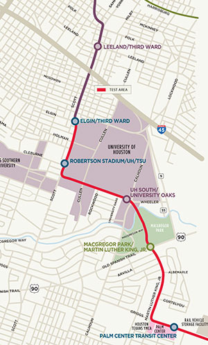 No, the new light-rail lines won’t be ready to carry passengers anytime this year — if you’re looking for a ride, check again in 2015. But over the next couple of weeks, you may see a Southeast Line train or 2 skirting the western and southern borders of the University of Houston. Starting today, Metro will be shuttling vehicles along the path shown in red on the Purple Line map at left, from the corner of Elgin and Scott Streets through MacGregor Park to the vehicle storage facility just past the Palm Center Transit Center — for safety testing. Map: Metro

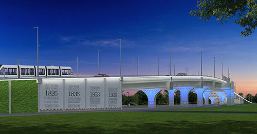
Metro has posted the latest designs for the enormous Hughes St. overpass along Harrisburg Blvd. on the far-east segment of the East End rail line. The $27-to-$42-million bridge is meant to carry cars and Green Line passengers over the Union Pacific East Belt freight rail line that runs north-south just west of Hughes St., between the soon-to-open East End line’s between the future Altic and Cesar Chavez stations. The posted design concepts, Metro notes, combine a “garden” wall and a wall noting a few 4-digit numbers important in the history of the neighborhood with a ribbon of white LED lighting above and blue accent lighting underneath and along the columns:
At the End of the Green Line

METRO ADJUSTS ITS REIMAGINED BUS ROUTES 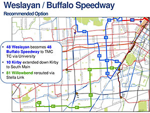 So the reviews of the proposed “System Reimagining” of Metro bus routes are in and . . . generally positive, but a big bunch of letter-writers hated what the new layout might or might not do to public transit along Weslayan, Jones Rd. and Jersey Village, and the Louetta and Vintage Lakes area. So the newly revised map, which Metro unveiled at its board meeting yesterday, recommends some adjustments to proposed service changes in those areas. The new 48 line, for example, which formerly was planned to run straight down Weslayan to the South Loop, would now connect the Northwest Transit Center to Greenway Plaza, the Rice Village, and the Med Center; the new 10 route down Kirby Dr. would now extend further south to S. Main St. Don’t like these changes to the changes? A few alternative route adjustments were presented as well. If the new plans are approved at next month’s meeting, the new bus routes and schedules should go into effect next June. Here’s the whole revised reimagined network map in one big PDF. [Metro; previously on Swamplot; all plan materials]

COMMENT OF THE DAY: NAVIGATING HOUSTON’S HEAVILY CONGESTED FUTURE  “I’m for better transit (I won’t be mode-specific here), but it should never be sold as making the streets less congested for you to drive around on. While it may take some cars off the streets, Houston’s congestion is likely to be massive enough that you’d never notice. Do NYC and LA have uncongested streets? Obviously not, even though both cities have much much better transit than Houston — meaning they have better alternatives to being in congestion and having to find parking. Congestion and difficult parking are our future (I wager even with self-driving cars, if they’re all personally owned) — everyone needs to be at peace with that.” [Local Planner, commenting on Killing Any Chance of Later Rail Conversion on the New Post Oak Bus Lanes; The Bedbugs of Beverly Hill] Illustration: Lulu

WHEN HOUSTON HAD A PLAN, AND FUNDING, FOR A DOWNTOWN PEOPLE MOVER 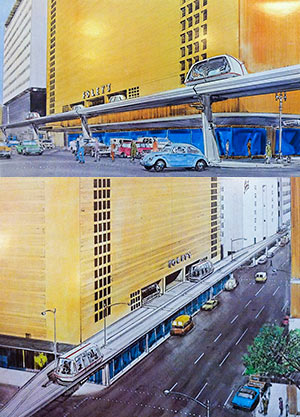 Digging into 40-some-year-old documents resting comfortably in the Houston Metropolitan Research Center at the Julia Ideson Library, Christopher Andrews pieces together the story behind the Downtown People Mover once planned for Houston. Houston was approved to receive $33 million in federal funding for the project in the mid-seventies, along with 4 other cities, but withdrew its application shortly after Harris County voters approved the creation of Metropolitan Transit Authority in 1978. After Houston dropped out (along with Cleveland and St. Paul), actual downtown people movers ended up getting built in Detroit and Miami. “The City of Houston’s 1976 proposal to the UMTA,” writes Andrews, “called for a 1.09 mile system, composed of 2.25 lane miles of track bisecting the ‘heart of the downtown core,’ stretching from the Cullen Center to the Harris County complex. It was intended to be fully owned, operated, planned and financed by the City of Houston, and was said to garner ‘strong and wide local support.'” A later report commissioned by the city showed alternatives to that north-south route along Milam St., including an elevated line running down Main St. past (and into) the (recently demolished) Foley’s building. [Not of It] Renderings: Sperry Systems Management/Houston Metropolitan Research Center

COMMENT OF THE DAY: RAILROADED  “Southern Pacific (not Union Pacific, as one writer claimed), demolished this station in 1959. Critics may blame Houstonians for failing to rally and save the building, but the fact is that the modern architectural preservation movement didn’t start until the early 1970s, and even my architecturally hip home town of Chicago let some classic beauties like Louis Sullivan’s Stock Exchange slip away before public sentiment for preservation began to build. The first downtown railroad-station preservation-restoration project did not take place until 1973, when the Southern Railway’s vacant Terminal Station in Chattanooga was transformed into a restaurant and hotel complex.
If anybody has any photos of the interior of the SP station in Houston I would like to examine them for a book I’m writing about what happened to each of the big downtown stations in North America. SP’s Houston Station was designed by Texas’s most celebrated architect, Wyatt C. Hedrick, who also designed the Shamrock Hotel, the T&P station in Fort Worth, and dozens of admired hotels, factories and commercial buildings. Photos of his T&P station are all over the Internet but SP demolished his Houston station before anyone had a chance to make any good photos.” [F.K. Plous, commenting on The Secret Train Station Hidden Downtown] Illustration: Lulu
“Southern Pacific (not Union Pacific, as one writer claimed), demolished this station in 1959. Critics may blame Houstonians for failing to rally and save the building, but the fact is that the modern architectural preservation movement didn’t start until the early 1970s, and even my architecturally hip home town of Chicago let some classic beauties like Louis Sullivan’s Stock Exchange slip away before public sentiment for preservation began to build. The first downtown railroad-station preservation-restoration project did not take place until 1973, when the Southern Railway’s vacant Terminal Station in Chattanooga was transformed into a restaurant and hotel complex.
If anybody has any photos of the interior of the SP station in Houston I would like to examine them for a book I’m writing about what happened to each of the big downtown stations in North America. SP’s Houston Station was designed by Texas’s most celebrated architect, Wyatt C. Hedrick, who also designed the Shamrock Hotel, the T&P station in Fort Worth, and dozens of admired hotels, factories and commercial buildings. Photos of his T&P station are all over the Internet but SP demolished his Houston station before anyone had a chance to make any good photos.” [F.K. Plous, commenting on The Secret Train Station Hidden Downtown] Illustration: Lulu

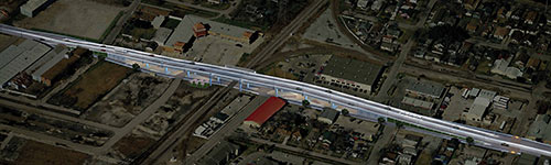
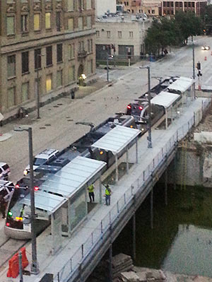 No, no one’s expecting Metro’s 2 new light-rail lines to open any sooner than late December (as Swamplot reported last week), but some progress toward that goal is now visible on portions of the East End and Southeast lines: “Live wire” or powered testing of the downtown tracks began this week. The photo at right, sent in by a reader, shows a Metro train moving unescorted along the tracks on Capitol St. for the first time.
- Southeast and East End Line coverage [Swamplot]
Photo: Nathan Juett
Power Up

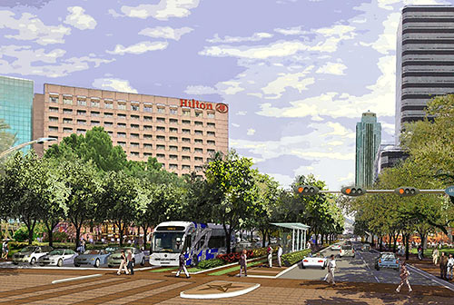
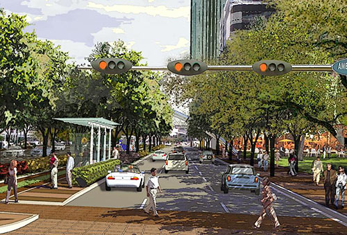
Here are some of the purty watercolor renderings the Uptown District has been presenting of what Post Oak Blvd. will look like after the addition of 2 dedicated bus lanes down its middle. The proposed changes to the thoroughfare won’t take away any of the 6 existing car lanes or 13 existing left-turn-signal lanes. There’ll be a few modifications, though: new protected-left-turn signals will be put in at West Briar Lane and Fairdale, for example, and 3 median openings will be closed. The space for the buses and 8 transit stations along the Boulevard between the West Loop and Richmond Ave will come from acquiring 8 feet of right-of-way from each side of the existing street. The bus lanes and light-rail-style stations will go in the median:
Uptown Transit

COMMENT OF THE DAY: WHAT IT WOULD TAKE TO BUILD A SUBWAY IN HOUSTON  “A subway WILL work in Houston, albeit at a significantly higher cost. I’m a civil engineer who builds tunnels, nationwide. They’re not even significantly more expensive in Houston than elsewhere. Tunnels in LA, NY, Chicago, Montreal, London etc all have to deal with bedrock — which is very expensive to tunnel through. Instead, Houston uses open-cut excavation and massive soil amendments + ground water pumping to tunnel. For example — the depressed portions of US-59 from Shepherd to Montrose (or the depressed portion of Beltway 8 from Boheme to I-10) are essentially a tunnel with no roof because they’re lower than the bayou and the ground water table; it took expensive soil amendments and pumps to build that, the same as a subway. Our commuter rail tunnel projects in LA are bidding for between $18M-$20M per mile of track, while the at-grade portions are only about $4M per mile. We consistently find that tunnels cost about 4x-5x as much as at-grade track. Meanwhile, elevated track costs roughly $25M a mile (6x at-grade costs). . . .” [Ornlu, commenting on Comment of the Day: How About a Rail Line Along the Bayou?] Illustration: Lulu

COMMENT OF THE DAY: HOW ABOUT A RAIL LINE ALONG THE BAYOU?  “I always thought a line down Memorial Drive along Buffalo Bayou would be awesome. It seems like it would be pretty easy to adapt the stretch of Memorial from downtown to Shepherd in to a rail friendly street — there are pedestrian crosswalks already, abundant lanes, and no stop-light intersections to contend with. They could take a lane or 2 from Memorial Drive, make a new right of way down the park, or even make an elevated line (which all of them should have been). The stops could tie in with cross streets or some the existing pedestrian bridges. This could be a real ‘showcase’ line for the city being right next to what seems to becoming Houston’s prime inner city park location. The line could continue all the way into Memorial Park and maybe even somehow get to the Galleria.
And of course Swamplot is the best forum for me to lobby my vision.” [actualarch, commenting on What’s the Point of Metro’s New Buffalo Bayou Bridge Under I-45?] Illustration: Lulu
“I always thought a line down Memorial Drive along Buffalo Bayou would be awesome. It seems like it would be pretty easy to adapt the stretch of Memorial from downtown to Shepherd in to a rail friendly street — there are pedestrian crosswalks already, abundant lanes, and no stop-light intersections to contend with. They could take a lane or 2 from Memorial Drive, make a new right of way down the park, or even make an elevated line (which all of them should have been). The stops could tie in with cross streets or some the existing pedestrian bridges. This could be a real ‘showcase’ line for the city being right next to what seems to becoming Houston’s prime inner city park location. The line could continue all the way into Memorial Park and maybe even somehow get to the Galleria.
And of course Swamplot is the best forum for me to lobby my vision.” [actualarch, commenting on What’s the Point of Metro’s New Buffalo Bayou Bridge Under I-45?] Illustration: Lulu

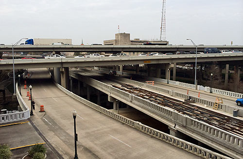
A reader who’s been watching construction of the new bridge that’s gone up over Buffalo Bayou and fitted neatly under I-45 at the far western end of the new under-construction Southeast and East End light-rail lines wonders what its purpose is. The bridge is beyond the planned Theater District stations, the last shared rail stops for the 2 lines. Is it a bridge to nowhere, or the starting point for some later western expansion along Washington Ave?
Heading West from Downtown

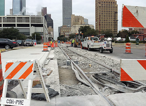
As noted in this morning’s Headlines post, yesterday Metro toted around some trains for “clearance testing” on the eastern stretches of the East End and Southeast rail lines scheduled to open later this year, in advance of electricity being brought down the lines. But downtown, repair continues on a 200-ft. stretch of track shared by the 2 lines on Capitol St. between LaBranch and Crawford — where the rails “probably shifted during concrete placement” and therefore didn’t set properly, a spokesperson for the transit agency tells Swamplot. The concrete has been torn up so the stretch can be rebuilt, level. The rework is being paid for at no cost to Metro by the contractor, Houston Rapid Transit, and will not cause any delay in opening the lines, the spokesperson says.
- East End Line and Southeast Line coverage [Swamplot]
Photo: Swamplot inbox
Get This Straight

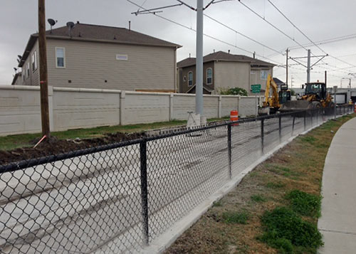
Why were crews yanking out and replacing a brand-new 240-ft.-long stretch of rail and concrete on the not-even-opened-yet Southeast Line at McKinney St. (above), next to the Columbia Tap trail in East Downtown, earlier this month? Because back on May 30th, a 7.2kV CenterPoint Energy electrical line fell onto the tracks and their overhead line three-quarters of a mile to the south, at Scott St. and Coyle St.
Zzzzzzap!
In addition to the McKinney St. burnout, 20-ft. sections of rail and track slab got zapped near crossings at Nagle St. and Elgin. At the incident site, 80 ft. of concrete and anti-vibration insulation had to be scrapped and replaced.
Hot Rails
