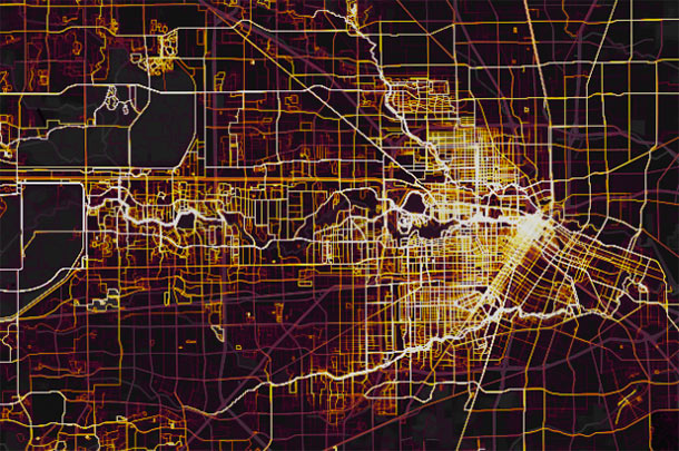
“On almost any map that plots some form of wealth,” writes the Kinder Institute’s Leah Binkovitz, “a familiar arrow takes shape over the Energy Corridor, Memorial and River Oaks, pointing east toward downtown.” Nowhere is that arrow clearer than on this map from fitness brand Strava, which visualizes running and biking activity in Houston from 2009 through last October. Strava updated its map — which includes 200,000 years worth of global exercise time — in November (although it’s been in the news more recently than that). Beginning just east of Hwy. 6, the arm of the indicator travels straight into Downtown, forming a point right around the Elysian St. bridge across Buffalo Bayou.
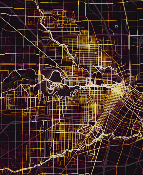
A little more zoom shows where the arrow’s edges run to the northwest and southwest of the city center:
***

That’s W. Tidewell Rd. at the top of the image — just north of where the figure’s upper wing begins in Oak Forest. Bounded diagonally by White Oak Bayou to the west, the wing drops down southeast through Shady Acres and the Heights before entering Downtown. On the south side of things, the arrow starts out in Meyerland and roughly parallels Brays Bayou on its way northeast through Braeswood Place, Rice’s campus, the Medical Center, the Museum District, Midtown, and part of Montrose.
- Global Heatmap [Strava Labs via Christopher Andrews]
- Houston in 2016, As Told Through 5 Maps [The Urban Edge]
- The Global Heatmap, Now 6x Hotter [Strava]
- US military reviewing security practices after fitness app reveals sensitive info [CNN]
- Previously on Swamplot: How Houstonians Can Get in Shape in the Shape of Texas; A Purple Map of Race and Public Housing Projects in Houston
Images: Strava Labs


Yup. That’s exactly where my wealthy friends and I ride our bikes. We even drank under the Elysian St bridge when it was too wet to ride, before they tore it down.
Maybe it’s just that white people like to record their exercise with smart phone apps?
The same ‘arrow’ is visible in census data where race is mapped:
https://i.imgur.com/85kvucw.jpg
https://demographics.virginia.edu/DotMap/index.html
This should be expected. ‘Running’ is one of the sports most disproportionately practiced by the rich.
Strava heat maps are a wealth of information. In the east bay area of California it’s a way for EBRP to monitor and track illegal singletrack mtb activity. Has nothing to do with race, ethnicity, color, or creed. If anything it’s a good thing for people to track their activity, discover areas to explore and build an active network of trails and routes that people can ultimately experience, enjoy and pursue. If Houston was smart they would find ways to use this data in order to enhance and promote this type of lifestyle instead of deterring it the way some other regions do…..
My monocle damn near fell into my cup of tea as I gasped in surprise of the “White Arrowâ€.
No longer the fattest city in the country! Thanks for exercising, people located in the arrow.
I can personally take credit for being the first to name the “Anglo Arrow” right here in the comment section of Swamplot a number of years ago :-) Now the media points it out anytime there’s data that highlight the Anglo or affluent population of inner Houston.
Rather, “point” it out…dadgum Latin-based nouns.
FYI: cycling is not just a form of recreation.
Except it’s not Anglo at all – certainly along the body of the arrow where I am, runners and cyclists are here from all around the world and just about every ethnicity. And that’s what makes Houston a cool place to live!
not that big of a surprise since any map will show you that our bayous form this arrow shape towards downtown. and seeing how most folks find it safer to use hike and bike trails to ride/run than the Houston roads with our crazy drivers, this make total sense. The lighter areas around the bayous (edges of arrow) are the folks making their way to said paths.
It’s mostly white people making that heat map. Cycling isn’t just for recreation, but Strava is used mostly by recreational cyclists. Road cyclists who like to track their distance and speed. They aren’t all white, but they are more white than the population of Houston.