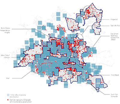
A graphic produced by UH’s Community Design Resource Center late last year maps Houston’s “food deserts” — sections of town that are more than a mile from the nearest grocery store and where a high proportion of residents live below the federal poverty line. The group found grocery-poor areas in parts of the Third Ward, Alief, Sunnyside, South Park, Acres Homes, Independence Heights, East Jensen, Kashmere, the Fifth Ward, East Little York and West Oaks. In all, the group counts more than 250,000 low-income Houstonians living more than a mile from a grocery store; according to their calculations, more than a quarter of that number have no access to a vehicle. A larger version of the group’s preliminary map, where blue squares represent grocery stores and each red dot stands for 50 people with income below the poverty level, is here.
- Houston: Desertia [Super Houston]


I don’t know if I am remembering this right or not, but I certainly know other Swamplot readers will correct me if I’m wrong…
Didn’t Independence Heights just get a large grant or other funding for revitalization? This would be a smart time for a grocer to build there- real estate is cheap and the neighborhood is about to get an infusion of development/capital. A new grocery store would also bring a lot of traffic from near by Garden Oaks and Oak Forest, who have to travel quite far to get to Kroger or Fiesta.
It’s misleading since population dots were not filtered and placed inside rich neighborhoods, the reservoirs, airports, lakes, etc. West Oaks is not Kelliwood and Kingwood most certainly has grocery stores. Why should I trust this?
HeightsLife:
A new grocery store would also bring a lot of traffic from near by Garden Oaks and Oak Forest, who have to travel quite far to get to Kroger or Fiesta.
______________________
What? Did they bulldoze the Kroger on W. 43rd between Ella and Oak Forest Drive while I wasn’t looking???
Agreed with skooljunkie above about Kingwood.
It’s missing 4 of our 6 grocery stores. There are also a bunch of dots in the middle of Lake Houston and inside the airport.
This map gets a 0 on the credibility scale…
Would you build a 30MM grocery store in one of these neighborhoods…didn’t think so.
If you were the proprietor of a grocery business, would you invest the money to serve these areas?
GO Al,
Really? Was that necessary?
If you live at 30th and Yale, a store in the southern part of Independence Heights would be much closer than the Kroger on 43rd. The point is, if a company doesn’t think just IH itself is viable, there would be ample traffic from other nearby neighborhoods, including OF/GO, plus Sunset Heights, Monte Beach, et al. All these places have access to groceries, obviously, but an IH store would be even closer to some parts of those neighborhoods.
Now put your question mark key away.
Looks as though they go where the money is and lonestar cards aren’t. Can you blame them they are capitalistic, and profit driven. There is no philanthropy to be found in trying to make a buck.
Why is the one mile radius a square? Bad map.
I question what they are considering a grocery store. When I Googlemap my house and say search for grocery, I get things like gas stations, convenience stores and drug stores. Hardly what I would consider a proper grocery store.
I certainly do agree with them on there being a lack of grocery stores in the southwest part of town. Dear Kroger, please send one of those excess stores my way.
Ever notice that there are no “food deserts” where Asians live, no matter how poor we might be?
I’d be curious to see what percentage of these 250,000 are also obese or have other nutrional related health issues. No access to healthy/fresh food = a lot of really bad, really cheap processed food.
“No access to a vehicle”? I rode my bicycle more than a mile to the grocery store last night. Vehicle != car. Houston.
OK, this map looks wanky. First, why not just show the grocery stores? Why are the blue “radius” markers square?
Also, if you take a good look, there are blue squares in MANY locations with a concentration of red dots.
I’m not sure what they are trying to prove, but this map isn’t a good start.
And if you want grocery stores in less affluent neighborhoods, tax breaks and incentives are a good place to start. That’s how many neighborhoods are “turned around.”
LT: Really? People are fat because they’re an extra mile or so away from grocery stores and therefore cannot partake of “fresh” foods? No. People are fat because they eat the wrong foodstuffs too much and too frequently, because they have a genetic predisposition, or because they are not physically active enough.
What, you don’t believe me? First go visit the Whole Foods in Montrose and realize that a fair number of the shoppers there comprise the affluent population east of downtown, miles and miles away. Then go visit one of those gigantic Chinese buffets along a freeway feeder road and look at your fellow diners. What’s that, you refuse to eat at such a place? It doesn’t meet your criteria? Well then obviously you aren’t thinking like a fat person. In this country…it’s not about the cost of food and its not about the convenience of food. It’s about personal preferences and priorities.
Whoa Niche – such virtiol. I’m sorry, do I know you? Did I insult your mother? Run over your puppy? Come steal your lilac bush in the middle of the night? No? Oh that’s right – you don’t actually KNOW me. So simmer down and cool it with the unwarranted snarky comments.
Read this:
http://jacksonville.com/news/metro/2010-04-17/story/poverty-obesity-hunger-paradox-northeast-florida
Or this:
http://www.nytimes.com/2010/03/14/nyregion/14hunger.html
Or….this:
http://thestir.cafemom.com/food_party/100230/the_obesity_and_poverty_connection
There is a link between poverty and obesity – and yes, typically people who don’t have money don’t have any access to cars, which means they don’t have access to grocery stores where they can purchase healthier food. If someone is living in a neighborhood that is too poor to support a grocery store, the chances are high that he also doesn’t have easy access to a vehicle and therefore is making due with he can find at his local convenience store. Spend 5 minutes with Google and you can find countless studies that support that.
As for MY eating habits – I’ve spent some $$ at Whole Foods and gone back for seconds at Panda’s Chinese buffet (though for my money, I’d prefer to get my sodium and MSG at Silver Palace). Careful about making assumptions about your fellow Swamploters, Niche.
Fundamentally untrue Niche. If I’m working two minimum wage jobs to try and feed a family and can’t afford a car then an extra two miles out of my way to pick up fresh produce really is a big deal. Assuming that the urban poor can travel “miles and miles” to buy groceries the same way the middle classes can is ludicrous.
Dang. I didn’t realize so many poors live in Memorial Park.
Independence Heights residents do grocery shopping at the wheezing old Kroger on 20th.
NOW WHERE DO ME BUY ME GOBBLE GOBBLES?
WEEEEEEEEEEEEEEEEEEEEEEEEEEEEE
BYE BYE
Dramatically oversimplified, there, Niche.
…and your anecdotal “proof” is, well, I’d just delete the post if I were you.
“It’s about personal preferences and priorities”. You betcha. That simple.
Wow. Marie Antoinette graces us with a rare post.
To an extent of course it is about personal preferences so as much as I hate to say it Niche has a point. The research has generally shown that putting grocery stores close to people is not enough on its own. You still have to persuade people to shop healthy rather than unhealthy. However if the sources of healthy foods are not available you have lost that fight before you even start.
Houston and healthy is almost an oxymoron.
15th fittest city in the US per Travel & Leisure magazine.
Also the fattest city, see link:
http://www.usatoday.com/news/health/2003-01-01-cities-usat_x.htm
Last time I checked, there’s a perfectly nice Randall’s store right smack dab in the middle of Kingwood although it doesn’t appear on this map.
I wonder how much of the remaining data is bogus.
Ah but that was the 2003 survey Corey. As of the 2009 version we are now only 5th fattest!
While the graphics may need some refining, I think the map brings up interesting issues relative to availability of food (fresh or processed) in Houston.
Where I live, in the Montrose area, I will soon be within a three minute drive of TWO Whole Foods, a brand new HEB, an updated Kroger, another supernice Kroger on West Gray, a Randall’s, a Fiesta, etc. Three of these will be within a 10 minute walk from my house. I’d wager that there are few (no?) other neighborhoods in America offering this kind of variety and abundance.
Meanwhile, my fellow Houstonians who happen to live in the 3rd Ward have no real shopping options nearby. They have to drive 10 or more minutes to perhaps suboptimal grocery stores and fresh produce. But there is a plethora of fried and fast food options in their neighborhood. So, when deciding where to eat quickly, McDonalds or the Navy Fried Seafood store seem to be the first choices.
I think what Superhouston is implying is a possibly causal relationship between poverty, health, and a lack of fresh food. The connection is complicated, multi-dimensional, and definitely worth talking about.
Just want to say, this isn’t a very accurate map.
Was looking at the Kingwood/Atascocita area..and its only showing ONE grocery store.
Doesnt give much credibility to the entire map…if you ask me.
Has having University of Houston within walking/biking distance increased the rate of HS/college graduates in that area?
Minimally, if at all.. because this is a matter of culture and economics, not accessibility. The same is true of eating habits, and thats why no one is opening a grocery store in the 3rd ward.
Look at other areas of town with similar socioeconomic situation but different culture, ie the hispanic areas around long point or near chimney rock and south rice. On Gulfton over there they have a Kroger which is tailored specifically to the Hispanic community, all the external signs are in spanish and the store sports red white and green colorscheme. Why? Because its a different culture and thier eating habits make it profitable for Kroger to stay in that location.
What counts as a grocery store? Only giant chain stores? Or are there mom-n-pop grocery stores in these underserved areas?
Because, for example, it’s a myth that Detroit has no grocery store in the inner-city”
http://www.boingboing.net/2011/01/27/detroit-has-grocery.html