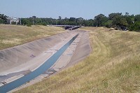
COMMENT OF THE DAY: STRAIGHTENING OUT THE CONCRETE-LINED BAYOU PARADOX  “While I am no run-off-water-channeling expert, I am under the impression that tossing out the concrete is not just for appearances. The concrete ditch moves the water faster than the natural channel, and can [thereby] actually aggravate flooding rather than cure it. Returning to the natural channel structure may mitigate flooding.” [Al, commenting on Might White Oak Bayou Ditch Its Concrete?] Photo of White Oak Bayou channel: Swamplot inbox


Well that was the point originally, to speed up draining into the bay by “speeding up” bayous. There was even talk after Allison to install some sort of turbines east of downtown to speed them up even more. The problem at the end has always been the work around town is half-assed and disjointed, and not a complete carefully designed system that works as a whole it was supposed to be. So concrete or natural it won’t make any difference until all the counties and flood control agencies design a system that works regionally and not just push the problem form one spot to the next.
The reduced friction of the concrete lining increases the capacity of a ditch compared to a similar-sized grass-lined ditch. Adding faux-natural bends will also slow drainage and increase flooding. They may look ugly, but the concrete is our best bet for getting the water out of the city without wiping out (normally) dry land to make the bayous wider.
Perhaps we can separate the discussion into two different areas. Firstly, flood control is an important issue. Years ago, I took a course in environmental geology, in which the prof. espoused the idea that while straightening and concreting streams was effective in moving runoff water through quickly, the strategy just moved the problem downstream. If the downstream could handle the increased water volume (maybe yes, maybe no) that would be OK.
The other area relates to aesthetics and quality of life. Personally, I fall in the camp of trying to mitigate flooding (which to a large extent is exacerbated by us paving over hundreds of square miles with concrete) using detention ponds. Plus, using those ponds and the streams themselves for recreational purposes.
I realize that many people feel no attraction to the idea of increasing green space and devoting more land to recreational use. However, a lot of people feel otherwise. Is some sort of compromise impossible?
Medium/large rain events in a land that was naturally a swamp (a low lying area with slowing moving, nearly at sea level bayous, to the point that you can detect salt water as far in as shepherd at high tide in Buffalo Bayou) are going to cause flooding. The water has no where to go. End of story.
Yes the Army Corp of Engrs, and cities afterward, built channelized bayous/ditches in order to move flood water away ASAP. But this practice is being re-considered because the up-stream community simply inundates its down-stream neighbor! The practice is not sustainable.
A large wide-ranging city like Houston cannot shoot run-off water into ‘the wilderness’ because there IS none anymore – it’s all suburbs now.
There are some creeks out in the north/northwest side of the metro area that seem to have been widened/deepened significantly without using concrete. It creates a canyon-like effect making bridges seem higher than they are, an aesthetic plus no doubt for many people. Functionally, it is easy to see how such a setup could be better for flood control.
We are talking about White Oak Bayou. It empties into Buffalo Bayou just before that becomes the Ship Channel. It isn’t like moving the water through White Oak Bayou faster is going to dump it into some idyllic, unsuspecting neighborhood. It’s going to dump it into Galveston Bay. If Buffalo Bayou and the Ship Channel can’t move water fast enough, that’s the bottleneck that needs to be addressed.
@Memebag
Flooding due to the channelization of White Oak is exactly what happens, or at least what happened in Allison. I wasn’t here at that point, and this doesn’t exactly align with my studies, so please forgive if I misspeak on minor details.
Here is my layman’s terms understanding of what happened: White Oak, being channelized, has capability to drain faster with a flow several times that of Buffalo Bayou. During Allison they both had high flow rates; due to the fact they intersect at near 90 degrees, the faster flow and greater volume of White Oak acted like a partial dam of Buffalo and the water level on Buffalo went up behind downtown. East of downtown was ok because it could handle the volume from White Oak and part of Buffalo that was draining (that is, since it was backing up on Buffalo and in downtown, there wasn’t as big of a problem East of downtown).
Duh, rainfall and run-off water needs to go somewhere.
If you can’t shunt it out of the way to someplace else (channelizing bayous), it has to be held back (reservoirs) or slowed down to soak in and evaporate over a longer time.
This takes space – wide natural places with no buildings. Forested better than clear-mown. Denser city footprints with large natural areas mixed in.
The real solution is engineering and good land cover practices UPSTREAM. By the time the flow gets to this point there is no real answer. Just like your child and your 401k, the earlier in the life cycle you contribute, the more impactful that contribution will be further down.