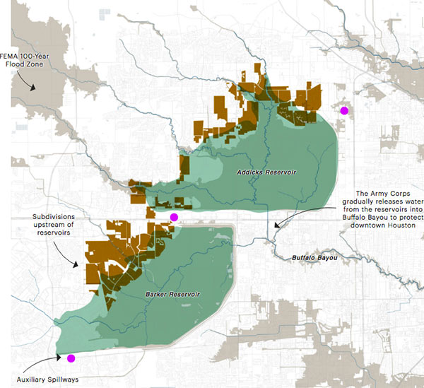
STUFF YOU PROBABLY SHOULD KNOW ABOUT THE ADDICKS AND BARKER RESERVOIRS  Lived in Houston for years but still coming up to speed on how the Addicks and Barker dams are supposed to work — just as the reservoirs reach to their highest-ever levels? This brief explainer from Kiah Collier and Neena Satija of The Texas Tribune Al Shaw and Lisa Song of ProPublica should overfill you with info: “As of now, the Army Corps says there’s enough excess water in the reservoirs that some of it will flow around (not overtop) these auxiliary spillways. . . . The Army Corps can’t say exactly what areas might experience additional flooding, but local officials listed 53 subdivisions in the Addicks watershed and 40 in the Barker watershed (shown in brown in the map above) at high risk of flooding. Jeremy Justice, a hydrologic analyst at the Harris County Flood Control District, said two subdivisions near the Addicks reservoir—Twin Lakes and Lakes On Eldridge—are particularly vulnerable to flooding from the Addicks spillway. Those homes ‘probably should never have been put there,‘ he said.” Thousands of homes around the reservoirs have now flooded — some because they’re close to rising bayous, and some because of bad neighborhood drainage, they write. “But many are flooding because they are in an area that the Army Corps actually considers to be inside the reservoirs. (See map.)” [Texas Tribune; ProPublica version with links; previously on Swamplot] Map: ProPublica
Twin Lakes

- 5623 Grand Floral Blvd. [HAR]

We have a winner — right on the nose! Who gets that RDA membership?
Many excellent — and entertaining — guesses in this week’s competition. There were 4 for The Woodlands and 3 each for Kingwood and Katy. Sugar Land and First Colony each got 2 votes. The rest: Clear Lake, Brook Forest, Cypress, Silverlake, Bellaire, the Energy Corridor, Cinco Ranch, Kelliwood, Bay Oaks in Clear Lake, “north of I-10, directly west of Barker-Cypress Rd., off Parkview Rd.,” “near Barker Cypress,” Barker-Cypress “in the vicinity of Pine Forest Country Club,” Greenhouse, “near a Hobby Lobby,” Missouri City, Lakewood Forest, Pearland, Twin Lakes, Jersey Village, Northgate Forest, Wimberly in Deer Park, the Lakeside area (“1970s early 80s pre bust energy corridor north of Westheimer south of Memorial”), near Fry Rd. south of I-10, Meyerland, below Memorial west of Voss, and Spring.
But BenC wins this week’s prize — a one-year individual membership in the Rice Design Alliance — for this enthusiastic entry:
Lots of oversize rooms and a pool make it ideal for energy corridor expats coming over from the dreary cold homeland. An outside picture would show at least one V8 powered car/suv.
Too big for the south of I10 energy corridor, to old (black appliances) for Lakes of Eldridge. I’m guessing twin lakes. Where ever it is the agent should earn a double commission on the sale.
Here’s more detail:

