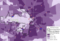
COMMENT OF THE DAY: ARE THE MONEY AND THE WATER FLOWING THE SAME DIRECTION?  “So I was looking at this the other day and a thought just hit me, based on a comment on another thread: Is this trend of gentrification following the bayous? Seems like that is a major draw to new development, and with the transition of the East End and Third Ward, it looks like a possibility.” [Mr.Clean19, commenting on A Purple Map of Race and Public Housing Projects in Houston] Map: Texas Housers


I wonder if it’s just that the Anglo Arrow follows riparian forests, as they are the most picturesque parts of the Houston area proper, therefore the most desirable and with the highest land values.
Development goes where the developers think buyers will want to live.
The bayous are the best place to make the walkable, bikable new Houston at and spread it from them, also no cars so if anything just pedestrian vehicles like segways, etc.
It is only circumstantial. As the west side gets pricier, inner loop improvement moves eastward, to the last remaining areas that are still affordable. It just so happens that due to our geography, the bayous also flow eastward, toward the ocean. So yes – gentrification is moving eastward, but it has nothing to do with proximity to any water courses.