
COMMENT OF THE DAY: TRACING THE ROOTS OF THE HOUSTON GRID 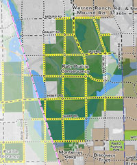 “The Republic of Texas in 1837 created various categories of immigrants in order to assign land grants. The coastal regions and plots fronting major rivers were for the most part already claimed by settlers that had arrived under Mexican governance, so what was allocated for new settlers was primarily west and north of the coast and between rivers. Most of these grants were made in 640-acre (1-square-mile) increments (or double or half that). These were made as geometrically regular as possible given natural features. In the nearly-featureless prairies west of Houston and notably in the Katy Prairie, you had these perfect grids dominating much of the plat maps. Roads and fences were built to follow that pattern for obvious reasons. The legacy of this system has shaped policy ever since.” [TheNiche, commenting on Ring Around the Katy Prairie, and Other Orbital Highway Fun] Map of previously planned thoroughfare routes across Katy Prairie Conservancy preserve: Harris County Planning and Infrastructure Department


Wrong. Early land grants (Spanish, republic of Texas, early US) were given out in irregular shapes. The 1 square mile grid system was imposed on the majority of the US by Thomas Jefferson after the Louisiana purchase. Texas was not a part of the Louisiana purchase so the Jeffersonian system was not applied to Texas. It was applied to Oklahoma and that is why the panhandle has many tracts that are square in shape even though they were not officially surveyed as part of the township and range system. Go to the Texas railroad commission GIS and zoom in on the Houston area. Then do the same for the panhabdle. You’ll seem I am correct.
Oh wait… If you go further west they do turn into squares. Interesting
Many of the Spanish land grants in Central Texas actually use rivers as boundaries, causing the “grid” to go 45 degrees off of a North-South system. Not sure what you mean by “categories of immigrants” being used in doling out land.
@ Superdave: It would appear that Swamplot cited a source as a link that you can access by clicking the phrase in question.
.
Yes, you’re right that the Spanish and Mexican grants tended to go off of rivers. Early settlers were fixated on rivers for transportation, irrigation, and alluvial soils. That land got allocated early on and in a different pattern. The system that came later wasn’t always comprised of a perfect grid because it had to take the former allocations into account as well as natural features, but sometimes it was. In the Katy Prairie, it certainly was.
The early Texas, and Mexican, land grants were generally based on either a league or a labor, or both. A league was 25 million square varas(4428 acres), a labor was 1 million square varas(177 acres). After a while the Republic of Texas started giving grants in fractions of 640 acres, with a set of rules on how much land a person was entitled to, depending on when they arrived in Texas, and other factors.
I have one ancestor who arrived in Matagorda the day after the Battle of San Jacinto, and he was granted a league and a labor in Jackson County. Another came a year or two later, and ended up with 640 acres in Taylor County, and another in Fisher County.
If you look at land grant maps, many of the Mexican leagues were long and thin, not square. As mentioned above, one of the best ways to see the grants is on the RRC site.
The tracks will follow some of the patterns listed here, but the development and road patterns follow the pattern of the top mode of transportation at the time. You can tell the age of an area by whether the roads/development is parallel/perpendicular to a railroad or an interstate.