
CROSS-COUNTY ACCOUNTING FOR THE HOUSTON FLOODING PUZZLE 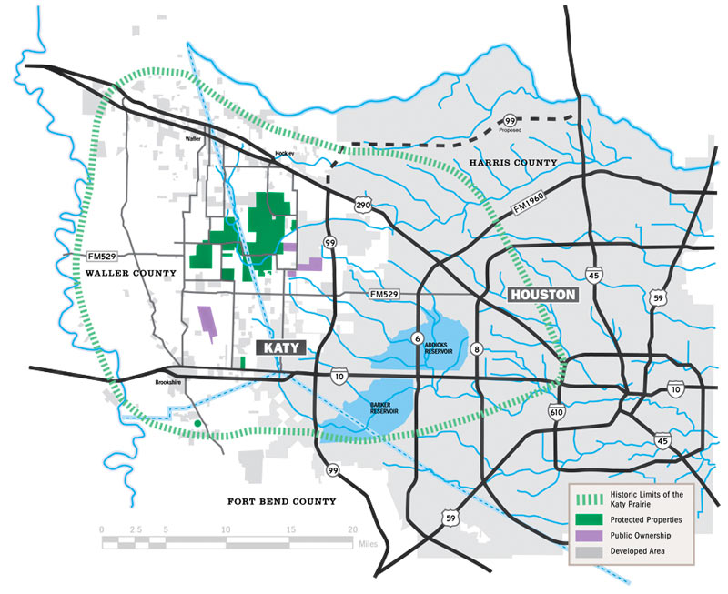 Kim McGuire checks in on the local hardscape in Friday’s Chronicle, as part the latest piece in a series examining roots of the area’s chronic flooding habit. The Houston Area Research Council tells McGuire that roughly 337,000 out of 1.1 million acres of Harris county were covered by surfaces impervious to rainfall runoff as of 2011 (the most recent year of data); meanwhile, softer surrounding counties (including the ones hosting much of the much-reduced Katy Prairie) have been racing to catch up with much higher rates of added hard area. McGuire notes that while developers are generally required to add detention basins to projects that increase the rate of runoff from their land, this does not actually require them to “eliminate runoff from their projects.” Mark Mooney, an engineer for Montgomery County, also tells McGuire that despite the regulatory scrutiny on any individual project with respect to keeping a balance betweeen added runoff and added detention, its still “clear [that] the way water moves through our county has changed. It’s all part of a massive puzzle everyone is trying to sort out.“ [Houston Chronicle; previously on Swamplot] Map of Houston drainage and current/historic Katy Prairie extent: Katy Prairie Conservancy


Every editorial and study which I have seen, fails to consider the plug in the bath tub. Every drop of rainwater in the metro area ultimately finds its way to Galveston Bay and then the Gulf of Mexico. During the major flood events this spring the the tide was exceptionally high and there was a strong steady wind from the southeast. The waters of Clear Creek, and the San Jac River were nearly three feet above normal before the first drops fell. There was no outlet for the rain and it backed up and up and up. Nothing had changed for this flood except the wind and the tide did not work in favor of Houston.
We need to stop building major roads so far out west. It is very bizarre that we keep doing this rather than investing in the “inner neighborhoods” which now extend out to highway 6. We should have built up the area between 610 and beltway 8 to keep people in the city core, improving schools and Infrastructure, rather than building these monster commutes that people hate.
I think pier and beam pontooons is going to be a thing of the future.
@Observer Not trying to pick a fight here, but your comment is very uninformed. The “We” you are talking about is not the City of Houston… it’s the private developer/landowner who chooses to invest their time and money to build a product. If the product wasn’t selling so well, maybe they wouldn’t risk building it. The reason “We” don’t build up the area between the Loop and the Belt is because Houstonians aren’t real city-dwellers. Unless we are near downtown and living in a really vibrant area, there’s no desire to live in small, compact homes with little space to grow or spread out. There’s nothing bizarre about this behavior, it’s supply and demand and one of the fundamental reasons for Houston’s growth and bright future. San Francisco’s model of a dense urban core is really great if you have $1M in the bank and can afford to live there. The other 99.5% has to settle for living in less expensive and less desirable outer areas. You can’t have it both ways.
@Gillo – developers build where there are roads. When “we” build major roads in rural prairies, developers will build houses there bc it cheaper and subsidized in the form of free roads.
–
There are tons of large lots inside the city limits. By contrast, new developments are packed closely together.
–
Perhaps you think it is okay to use words like “uninformed” because you are so used to having that word applied to you. It’s actually rude, thoug, unless the comment really is uninformed like yours was.