
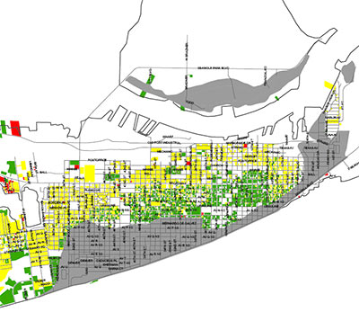
FEMA-approved colors liven up this property-damage-assessment map for 24,000 structures in Galveston.
The red areas are “unsafe; leaning; structurally unsound; completely destroyed; collapsed or structure missing.”
Yellow means “general interior flooding; wind damage; or significantly damaged, but repairable.”
And green means go! “No damage or only minor damage; or missing siding; shingles; handrails; breakaway walls.”
The gray areas? “Flood zone.”
More colorful maps of other Hurricane-Ike-hit areas of the city are available on the City of Galveston website.
- Damage Assessment Map for Areas 61st Street East, 61st Street West to Jamaica Beach, and Jamaica Beach West to San Luis Pass as of 10/15/08 [City of Galveston, via Hair Balls]
- City Releases Damage Assessment Map & Issues Guidance for Property Owners [City of Galveston]


Yeah, I saw that. Flood zone? What does that mean? I thought some of the Seawall businesses were open again.
I think grey means:
‘whatever/gonna flood again/no sense spending the time to assess it.”
Actually, Zone ‘x’ is not a flood zone at all. Check the Fema definition:
An area that is determined to be outside the 100- and 500-year floodplains.