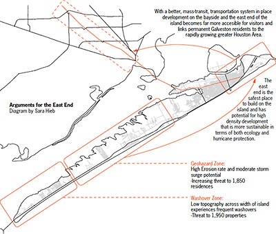
A new report from Rice University’s Shell Center for Sustainability includes a few suggestions for the future of Galveston: step all development back from the beach in anticipation of continuing erosion; use a map of the island’s cataloged geohazards to guide where development should go; or permanently abandon the west end of the island entirely. That third recommendation comes with 2 possible natural enforcement mechanisms: a projected future hurricane headed for the western tip of the island, or a combination of sea-level rise and continuing retreat of the shoreline. All 3 scenarios encourage concentrating residents and visitors in the “higher, thicker, wider” East End. A collaboration between earth scientists and the School of Architecture chock-full of charts and diagrams, the Atlas of Sustainable Strategies for Galveston Island includes a series of large-scale design proposals cooked up by Rice architecture students.
***

- Atlas of Sustainable Strategies for Galveston Island [Lulu]
- A more sustainable Galveston [Rice News]
- Galveston Island gets tough advice from Rice study [Houston Chronicle]
Video: Rice University. Diagram: Sara Hieb


In other words, common sense — a quality historically lacking in Galveston politics.
I agree, it’s just common sense. I think most of us who are familiar with Galveston have been watching in horror at the pace of development, or proposed development, of the west end.
Let them build on the West End, and let them self-insure. Their choice.
Mel:
Exactly. But not “let them self insure” – require them to self insure.
For once, the “free market” might actually work. Build anything you want on the West End, but don’t expect to get any insurance on the structure. If you are willing to “go bare”, do it. Enjoy your vacation home for 6 months or 6 decades, at the whim of the hurricane gods.
The rest of us can thereby not participate in the building folly.
If those damn Owls keep making commonsense,
logical, sustainable proposals…
As someone who starting visiting Jamaica Beach in the mid-60s, I have seen a large community pavillion and about 5 rows of beach houses succumb to the Gulf. Hurricanes and high tides will eventually take the western half of the Island.
Remeber when it was possible to drive from Bolivar to Sabine Pass on 87?
For once, the “free market†might actually work. Build anything you want on the West End, but don’t expect to get any insurance on the structure. If you are willing to “go bareâ€, do it. Enjoy your vacation home for 6 months or 6 decades, at the whim of the hurricane gods.
Erosion will get them eventually unless they also pony up for re-sandification every decade or so. Barrier islands are meant to move around. Humasn spend alot of effort trying to hold them in place.
It always cracks me up when they refer to the different ends of the island as East and West. For some reason in my head I’ve always thought South and North. And why not? The thing is titled at an almost perfect 45-dgree angle.
What Ike did to Bolivar will be done ten fold to the west end one day by another storm.
Brittanie – It makes exactly the same amount of sense as our municipal fiction that the downtown streets parallel to Main run north and south.
i feel bad for everyone that lost their home during hurricane Ike, but that should be a lesson. Instead of building like crazy maybe some of the existing decrepit neighborhoods should be improved. There are so many beautiful homes and buildings already there. Its a shame to see these historic buildings go to waste.
There’s a really nice case study related to this: Jersey Shore 1962. Ian McHarg (Design with Nature, 1971) did a good job explaining why the development pattern (Building to the beach) led to so much damage to both the island and to the property on the island after a large storm passed through. Only bad things can come of mistreating an island like Galveston.
I’m sure Galveston will prosper even more without the millions in property taxes from West End development.