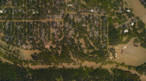
Here’s the latest publicly available high-resolution aerial imagery of Houston-area flooding, in an interactive map you can use to zoom in and examine in detail and by address. The imagery in the map above comes from the National Oceanic and Atmospheric Administration, and was taken this past Wednesday and Thursday, August 29th and 30th — as floodwaters subsided in many areas of the city but continued to build in a few parts west.
Included in the portions of the city photographed by NOAA: the sections of Memorial south of I-10, west of Gessner Rd., north of Briar Forest Dr. (that’s below Buffalo Bayou), and east of the Addicks and Barker reservoirs. That’s the area where Mayor Turner earlier today said residents who already have water in their homes should probably leave their homes now if they haven’t already — because water is likely to remain in them for the next 10 to 15 days as releases from the dams continue.
To zoom in on the latest aerial imagery from that area, you can click on the search box in the map above and type “Memorial, Houston,” then click on the first option that appears below where you’re typing. Then zoom in further to see where the floodwaters are and aren’t. You can identify the date of the imagery and turn on and off various layers if you click on the lower of the 2 icons on the top right of the map. To view the map larger in your browser window, navigate directly to NOAA’s Harvey site.
***
Houston Chronicle and Washington Post journalists have both used images from these flyovers to create juxtaposed before-and-after images of particularly water-logged areas of the region. Here’s a slider showing what happened to Memorial Glen — just north of Buffalo Bayou and west of Beltway 8 — assembled by the Chronicle’s John D. Harden and Rachael Gleason, using NOAA imagery from Wednesday:
And here’s an image of roughly the same area from yesterday:

- Hurricane Harvey Imagery [NOAA, via CNBC]
- VOLUNTARY EVACUATION for FLOODED HOMES in WEST HOUSTON [Alert Houston]
- Before and after the storm [Houston Chronicle]
- Before-and-after visuals of the massive flooding in Texas [Washington Post]
Imagery: NOAA


