CINDY LIKELY TO SKIP THE HOUSTON HOTSPOTS, MAKE A BREAK FOR THE STATE LINE  Voluntary evacuation is the name of the game this morning for folks on parts of the Bolivar peninsula (at least for those with health conditions that make the possibility of power failure a big gamble to take). To the east, much of the upper Gulf Coast is already getting hammered with touring bands of pre-landfall rain from Tropical Storm Cindy, and the governor of Louisiana has declared a preemptive state of emergency in anticipation of flooding and tornadoes. But today’s weather models generally peg the bulk of the wind and water from the storm as veering back to the east of Houston itself, Eric Berger notes over on Space City Weather this morning. The worst of the storm seems likely to pull northward toward the swampy, beachy stretch around Beaumont, Port Arthur, the Sabine River, and western Louisiana; only a few feet of higher-than-normal tides and a (relatively) few inches of rain are expected around Houston and near the Ship Channel’s pretty lucky-so-far chemical complexes, along with some pockets of high winds. [Space City Weather] Capture of current conditions on Sunrise Beach: Bolivar Peninsual, TX
Sign up for the Newsletter
Tag: Bolivar

And now our feature presentation: an artists’ video on the Bolivar Peninsula left behind by Hurricane Ike, with commentary from former residents.
- Hell and High Water: Bolivar After Ike [Glasstire]
Photos: Bert Long. Video: Kelly Klaasmeyer and Bert Long
GROWING PROPERTY LINES ON THE BEACH The owners of more than 2 dozen properties on the Bolivar Peninsula have been planting grass and shrubs along the edges of the dunes on the seaward side of their land. Why? The General Land Office prohibits new construction beyond the natural vegetation line. “‘The front row (of beach houses) is gone, and they are hoping to establish the vegetation line where it was before,’ said Dan Peck, 54, whose neighbors planted a swath of grass about 250 yards long. . . . Peck’s house in the Singing Sands subdivision near Crystal Beach was in the fourth row from the beach before Ike swept away the front three rows of houses Sept. 13. The vegetation line is established by the General Land Office, but Land Commissioner Jerry Patterson said he may wait as long as two years after the storm before marking the formal line that could determine the fate of many Gulf properties.” [Houston Chronicle]
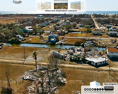
Tired of looking at the same old images of Hurricane Ike devastation? Now, thanks to the amazing aerial camerawork of Dallas’s Hawkeye Media, you can conduct your own Bolivar Peninsula post-disaster flyover, focusing only on the destruction you want to see — from the comfort of your own broadband internet connection.
Hawkeye’s interface allows you to navigate through the company’s panoramic overhead views of wasted homes and newly desolate landscapes, zooming in and out as fast as your middle finger can scroll.
- Bolivar Peninsula [Hawkeye Media, via SciGuy, via Hair Balls]
Photo of Nelson Lane, Crystal Beach: Hawkeye Media
