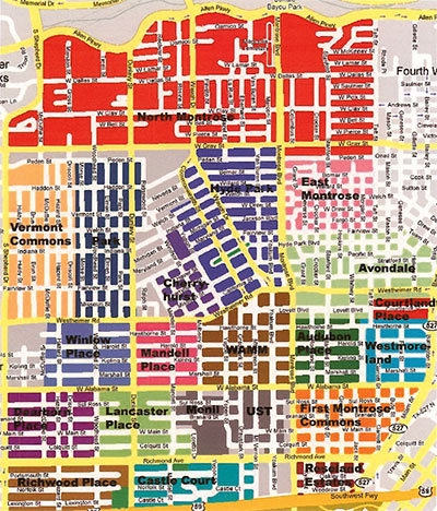
Reader rdan weighs in on Swamplot’s recent discussion about the boundaries of Montrose:
In order to address the confusion/questions over Montrose neighborhood designations, I dug up the attached map that was put together a few years ago by the Neartown Association, the umbrella organization for the roughly 20 neighborhoods and civic associations that constitute the area known as “The Montrose”. Some of the civic associations, such as Mandell Place, Winlow Place, and Cherryhurst, represent the original legal subdivisions that were established in the 20’s. Others, such as WAMM (Westheimer Alabama Montrose Mulberry Civic Association), were established more recently to help property owners re-establish deed restrictions that had lapsed over the years.
In doing a little research on HCAD, it appears to me that the areas represented by WAMM,
Audubon Place, a portion of Avondale (south of Westheimer?), and all or part of the UST campus covers what was the original Montrose subdivision.
- Comment of the Day: Name My Neighborhood [Swamplot]
- Comment of the Day: Where Montrose Begins and Ends [Swamplot]
Image: Neartown Association, via Swamplot inbox

