Reader rdan weighs in on Swamplot’s recent discussion about the boundaries of Montrose:
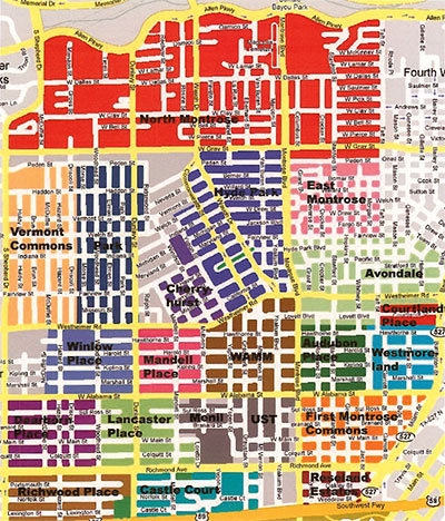
In order to address the confusion/questions over Montrose neighborhood designations, I dug up the attached map that was put together a few years ago by the Neartown Association, the umbrella organization for the roughly 20 neighborhoods and civic associations that constitute the area known as “The Montrose”. Some of the civic associations, such as Mandell Place, Winlow Place, and Cherryhurst, represent the original legal subdivisions that were established in the 20’s. Others, such as WAMM (Westheimer Alabama Montrose Mulberry Civic Association), were established more recently to help property owners re-establish deed restrictions that had lapsed over the years.
In doing a little research on HCAD, it appears to me that the areas represented by WAMM,
Audubon Place, a portion of Avondale (south of Westheimer?), and all or part of the UST campus covers what was the original Montrose subdivision.
- Comment of the Day: Name My Neighborhood [Swamplot]
- Comment of the Day: Where Montrose Begins and Ends [Swamplot]
Image: Neartown Association, via Swamplot inbox


Wow, that’s awesome. I’d like to see something like that for the entire city!
That is impressive.
YO!! SHOUT OUT TO LANCASTER PLACE!!!
I live in North Montrose (b/n Waugh & Montrose / W. Gray & Dallas) and our section is called:
Rosemont. I only know that from HAR – never seen any kind of sign or other indication that it is the name of my little piece of Montrose.
HCAD has us living in Montlew Place between Dearborn and Lancaster, but that isn’t shown on your map. Once again, we are orphans in the storm.
do one for Washington Ave! Plus- Bob Sennhauser’s installation at the Lawndale of Washington being gentrified would be perfect for the swamplot crowd.
AVONDALE in da house!
AVONDALE reprezentin’
here’s a list of the superneighborhoods as defined by the city:
http://www.houstontx.gov/planning/suprnbhds/recognized_sn.htm
and a map:
http://www.houstontx.gov/planning/suprnbhds/2008_COH_superneighborhoods.pdf
it doesn’t go into detail as to further segregrating out the individual neighborhoods within a super neighborhood, but i think this site gives some good information.
I used to live on Elmen St. back in the late 80s/early 90s. I always though I was in Winlow Place. Who knew I lived in Park?
Good find. Houston needs more maps like these so that we can develop a better sense of place. I hate it when even the newscasters have NO IDEA where things are.
miss_msry, there must be some history with the Dearborn Place designation for Montlew Place. Maybe it’s the residuals of an attempt at a neighborhood association several years ago? One of our Montlew Place neighbors has tried to uncover some neighborhood information by contacting the city, but his efforts have not been fruitful. Perhaps someone from the Neartown Association knows?
I think the little area between Richmond and the freeway, on either side of Yoakum, is Rossmoyne. Not sure whether it still has any kind of neighborhood identity at all.
The same patchwork of small neighborhoods is the way what we now call Midtown was developed, too — Kenilworth Grove was one, and Fairgrounds Addition on the southwest end of Midtown is another that still turns up sometimes, whatever that’s worth.
Thank you for putting this map up. As a native Montrosian who spent 33 years, from birth in 1965 to when I finally moved away in 1998, who always lived in Montrose (except for 2 years in the early 90’s when I briefly lived in Dallas), I’ve always been one to distinguish one neighborhood from another in Montrose. Montrose is basically a city within a city, unique and distinct from the rest of Houston. I grew up in Castle Court, and at various times lived in Avondale and in Montrose commons.