
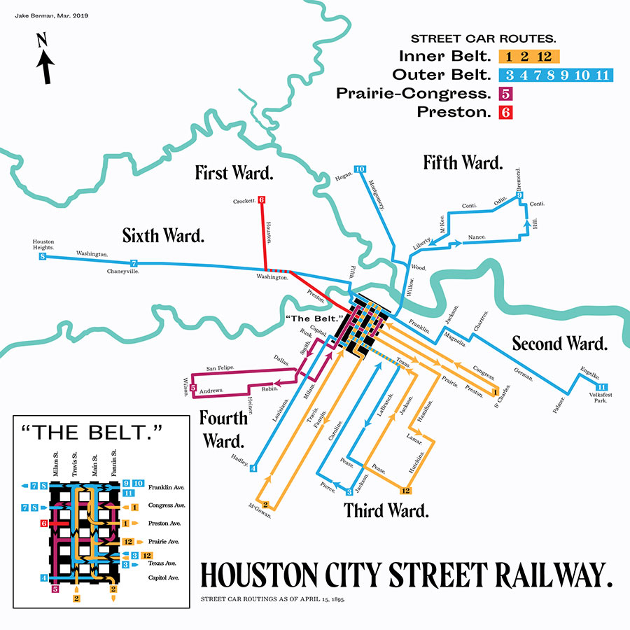
Houstonia’s John Nova Lomax, incessant chronicler of things-far-gone in the city, has put together a handy guide to the boundaries of a dozen-and-a-half retired Houston placenames, though a number of them (Astrodomain and Freedman’s Town, for example) aren’t so distant from regular use. But if you always wanted to know the way to Frenchtown, Chaneyville, or El Alacran — or the distance between Catfish Reef and Pearl Harbor — here’s your go-to map.
- Catfish Reef, Happy Hollow, and Vinegar Hill [Houstonia]
Map: John Nova Lomax
Local Extinctions

Dont forget about Courtlandt Place
Sadly, most of the cute little apartment buildings that gave Sin Alley (aka Mid Lane) its name are gone, replaced by $700,000 townhomes and mid-rise apartments. Still a nice neighborhood, though. It doesn’t seem like it’s right next door to the Target and a stone’s throw from the West Loop.
They forgot the area called Death Valley 610 @ Stella Link the main street was Link Valley. In the last 80s it was the biggest drug haven in Texas people would drive 100+ miles plus to buy drugs from these run down atp complex. I live just over a mile from this location and we did not have any problem from the area it was confined to that area
http://en.wikipedia.org/wiki/Link_Valley,_Houston
OK Mr. Lomax, don’t leave us hanging……will you tell us *how* some of these names came about? There are those that are easy to figure out but El Alacran, Vinegar Hill and especially Lovin Canada just have to have a fantastic back story.
Umm, Broadmoor is still called Broadmoor.
.
There’s even a park in Broadmoor called “Broadmoor Park” it used to be called “Triangle Park” because it is shaped like a triangle.
.
The sign that used to stand over by Austin High School that said “Broadmoor” came up missing a few years ago, but that doesn’t mean the neighborhood isn’t still called Broadmoor by its residents and anyone else referring to the neighborhood.