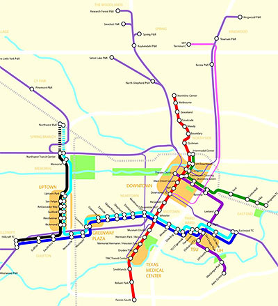
Metro hasn’t sent out an overview of its updated light-rail plans recently . . . but blogger Christof Spieler of the Citizens’ Transportation Coalition, who follows Metro’s plans carefully, has put together his own revised map showing the latest changes to the complete Houston-area “fixed guideway” transit map expected to be in place by 2012.
What’s new? Spieler notes plenty of adjustments. East of Downtown, the track carrying the East End and Southeast lines
swings around the future soccer stadium on Texas, then squiggles onto Capitol (the westbound track) and Rusk (the eastbound track), passing Discover Green, Minute Maid Park, and the Convention Center. At Main Street, a new station on the Main Street line allows for fairly easy transfers between the lines (unlike the old plan). At the same location, connection tracks allow East End Line trains to swing north onto the Main Street track, serving Preston and UH Downtown before terminating at the Intermodal Center. Southeast Line trains don’t make this turn; they continue on to the Theater District.
Also, changes to planned station locations:
there’s a new station on the Uptown Line north of Memorial Drive, but no Memorial Park station; there’s a station added in the Uptown area; there are new stations on the University Line in Gulfton and at Eastside; and the North Line has two more stations . . .
More detail — including the new express bus service from Downtown to IAH — in Spieler’s report.
- The map keeps changing [Intermodality]
- Metro 2012 Light Rail Map (PDF) [Intermodality]
- Metro 2012 Fixed-Guideway Transit Map (PDF) [Intermodality]


Any word on when Metro starts construction?
Is it ever going to greenspoint??