
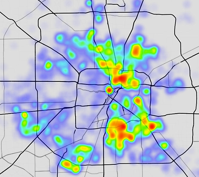
Where do Houston’s furrier residents tend to congregate? Jeff Reichman’s latest city data tinkering provides some clues — the clickable heatmap above highlights the areas where the city’s BARC program got the most calls this year for services like stray pickups and code enforcements related to domestic animals. BARC is currently in the middle of a 3-month push for a 90-percent no-kill rate of its collected and surrendered menagerie, after a successful 1-month push for that rate last November; the average euthanization rate for the program reportedly flipped from about 80 percent euthanized to about 80 percent released alive between 2005 and 2015.
***
The map above shows some 13,000 calls for BARC services — not counting thousands of cancelled requests — received between January 1 and mid-October for the organization. As to how many total strays are hanging out around town: The city points to some estimates that there could be more than 1 million stray animals residing within the city limits, though that number has been in dispute for a while now.
- BARC Animal Shelther & Adoptions [City of Houston]
- Previously on Swamplot: UPDATED: Where Trump Lost Harris County, Mapped; Where Houston’s Pot Smokers Live (the Ones Who Get Arrested); Where Houston’s Trump and Sanders Supporters Are Clustered, and Other Election Data Mapping Fun; Woodland Heights Now Dogged by Gang Violence
Map of 2016 BARC service call density: Jeff Reichman
Well look at that, it’s the arrow again…
Also, this is not “where Houston’s furrier residents congregate” but more like “the neighborhoods where people let their dogs run loose” or even “the neighborhoods where people dump unwanted, unspayed/unneutered dogs and cats”.
While I commend BARCs efforts to reduce the rate of euthanizing domesticated animals, I hope education of pet responsibility and spay/neuter is also included in their efforts. Ignorant people have caused this, education can help to fix it.
I wouldn’t believe it. Central houston nextdoor feeds are full of strays and pickups while utterly absent on these maps. They’ve just developed a large grassroots network of avoiding BARC.
Came to mention the arrow and Google beat me to it. Hopefully BARC can start enforcing their new laws and fine the crap out of folks that abuse animals.
Joel: normally, I would be inclined to agree with you; many heatmaps of [insert undesirable neighborhood activity/characteristic here] which show poorer areas having higher concentrations of said undesirable characteristic are often more a question of how frequently those things are reported to authorities vs. how prevalent the thing actually is.
However, in this case, I ride my bike all over the city, and I can absolutely confirm that the areas shown in red on this map are the places in which I’m likely to see (and sometimes be chased by) stray dogs.
Joel, central Houston is absent because of the very likes of community involvement where people step up to intervene ensuring dogs and cats do not end up with BARC.