
COMMENT OF THE DAY: WHAT COUNTS AS A SPRING IN HOUSTON 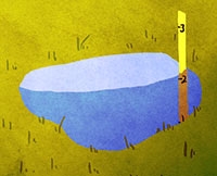 “The definition of a ‘spring’ can vary a lot, and is used loosely here.
In Harris County, where the topography is relatively flat, most of our ‘ponds’ and ‘lakes’ are either borrow pits (excavated to raise the grade elsewhere) or dammed-up gullies/ravines along existing bayous. In this case, it is the latter — a gully of Buffalo Bayou that was dammed up, then developed into a neighborhood.
A ‘spring’ is generally a point where the top groundwater table meets the surface. In our area, when we receive a lot of rain, the groundwater table can actually reach the surface. So a spring can range from a trickle of water to a puddle standing on the surface. When I dug the post holes in my backyard for my cedar fence, I hit groundwater at 2 feet deep because of recent heavy rain. In dryer periods, the water table drops, and springs continue to occur along steep cuts in the topography (either along a bayou that has eroded downward, or a man-made excavation). This is not what you find in the Hill Country, where large gaping holes in limestone spew thousands of gallons per hour, sometimes creating rivers out of nothing.
So effectively, any hole in Houston greater than 2 feet deep at some point will become ‘spring-fed.’ During the bad drought of the past few years, most likely the groundwater table dropped and stopped feeding this former gully of the bayou, and the ‘lake’ was most likely topped off by (1) automatic sprinkler runoff and (2) the small amount of storm water runoff they received, as the lake also serves as the neighborhood drainage ditch.” [Superdave, commenting on There’s a Tour of Texas and More in a Developer’s Lakefront Sandalwood Spread] Illustration: Lulu
“The definition of a ‘spring’ can vary a lot, and is used loosely here.
In Harris County, where the topography is relatively flat, most of our ‘ponds’ and ‘lakes’ are either borrow pits (excavated to raise the grade elsewhere) or dammed-up gullies/ravines along existing bayous. In this case, it is the latter — a gully of Buffalo Bayou that was dammed up, then developed into a neighborhood.
A ‘spring’ is generally a point where the top groundwater table meets the surface. In our area, when we receive a lot of rain, the groundwater table can actually reach the surface. So a spring can range from a trickle of water to a puddle standing on the surface. When I dug the post holes in my backyard for my cedar fence, I hit groundwater at 2 feet deep because of recent heavy rain. In dryer periods, the water table drops, and springs continue to occur along steep cuts in the topography (either along a bayou that has eroded downward, or a man-made excavation). This is not what you find in the Hill Country, where large gaping holes in limestone spew thousands of gallons per hour, sometimes creating rivers out of nothing.
So effectively, any hole in Houston greater than 2 feet deep at some point will become ‘spring-fed.’ During the bad drought of the past few years, most likely the groundwater table dropped and stopped feeding this former gully of the bayou, and the ‘lake’ was most likely topped off by (1) automatic sprinkler runoff and (2) the small amount of storm water runoff they received, as the lake also serves as the neighborhood drainage ditch.” [Superdave, commenting on There’s a Tour of Texas and More in a Developer’s Lakefront Sandalwood Spread] Illustration: Lulu


TLDR: Houston is a swamp