
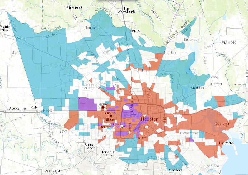
The land between the Grand Parkway and Hwy.-6-FM-1960 contained more than 37 percent of the construction sites in Harris County over the last decade, according to the Houston in Flux report and interactive maps released by the Kinder Institute for Urban Research last week. The maps above highlight regions where demolition and construction permits were issued at above-county-average rates between 2005 and 2015. Red shows areas with high demolition rates, blue shows high construction rates, and purple shows spots where both stats beat the average — areas authors Kelsey Walker and Kyle Shelton refer to as high-turnover (mostly concentrated in the Inner Loop and to the northwest).
Each subsection of the walkthrough embedded above contains a “learn more” link that provides access to (and a quick explanation of) various data types that can be displayed. A section on census-tract-level trends (including building, demo, and turnover, as shown up top) is followed by a section allowing a detailed property-by-property browsing of the data, as shown below:
***
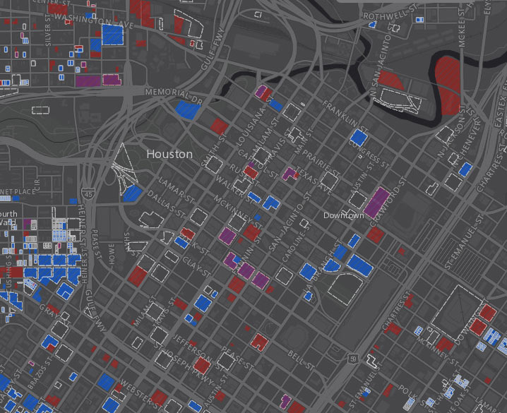
The red-blue-purple demo-construction color scheme stays the same for these close-up maps, with an additional option of displaying building permits (as dashed white outlines). The written report itself also goes into some bigger-picture analyses, discussing trends within each of the increasingly numerous loops around Houston — including the areas inside 610, from 610 to Beltway 8, from Beltway 8 to Hwy. 6, from Hwy. 6 to the Grand Parkway, and the zone beyond SH-99 in northwest Harris County.
- Construction in Houston metro area is far outpacing demolition [Rice University]
- Houston in Flux Report [Kinder Institute for Urban Research]
- Houston in Flux Maps [Kinder Institute for Urban Research]
- Previously on Swamplot: Daily Demolition Reports
Images: Houston in FluxÂ
Rice University, Hermann Park and Texas Medical Center all still exist: I just saw them today.
When you look at the map of where all of the construction is happening you should take a moment to ask our developers why they are putting so many in jeopardy including downtown Houston with all of this westward and northern expansion. With the recent 500 year floods and the continued subsidence in west Houston due to the MUDs use of underground water to water golf courses and yards in all of these new subdivisions they are creating flooding zones that can not be reversed. First they wipe out large swaths of open prairie which use to hold millions of gallons of rainwater, allowing it to slowly seep into the ground and replenish the aquifers instead of running down streets and gutters and flooding all of these low lying bowls of newly built neighborhoods, and finally out to sea with no value to the citizens.
Then people turn around and blame the city when the county and the developers who are paving the prairies should be taking the blame. Now every time we have one of these floods in far west and northwest Harris county the city of Houston, has to worry if the Barker and Addicks, reservoirs will hold and whether Buffalo, White Oak, and Sims will stay in their banks. We need to quit building on the prairie.
@ BobR: If the new development causes subsidence in the area of development (which is a function not only of the rate of draw but also on the geology), that gives rise to the phenomenon of ponding. That is bad for the development which caused the ponding, but to my mind it would seem to add stormwater detention capacity and would be a net improvement for the people and infrastructure downstream. My mind could be changed; present your evidence.