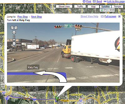
Google has just added street-level photos to the driving directions available on Google Maps. This means — if you’re headed through an area covered by Google’s Street View — you can now use photographs of each intersection to guide your journey, with helpful arrows superimposed to show your path.
Though the areas covered by Street View in Houston were recently expanded, most inside-the-Loop neighborhoods are still not covered. Let’s say you’re at the new Pagoda Vietnamese restaurant near Cottage Grove, trying to find your way to Chinatown — you know, that neighborhood on Bellaire in southwest Houston, where all those Vietnamese restaurants are. If you plot your trip using Google maps, the directions won’t show photos of your first few turns. From I-10 on, though, you get preview photographs of every intersection. And you can pan and zoom around them, as if looking for oncoming traffic.
After the jump: A video from Google, showing how Street View directions work . . . and what they’re good for.
