
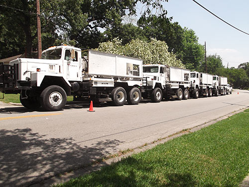
A couple residents of Park Place Acre Villa are interested in finding out what the point was of this fleet of Boone Exploration seismic vibrator vehicles rolling up Detroit St. and Findlay St. this week — and areas further east of the Gulfgate-area neighborhood earlier. After a few phone calls, a representative of council member Robert Gallegos reportedly showed up to talk to the crew from Premier Geophysical Services, which has been conducting seismic testing in the area.
***
For their tests, workers were attaching monitoring equipment to the corners of house foundations. “[There’s] no clear answer what all this is for,” writes one Swamplot tipster, who claims to have heard 2 separate explanations — that crews are looking for oil or minerals.
Photo: Swamplot inbox
Could be something to do with the thousands of oil wells in Houston.. gee..
http://wwwgisp.rrc.state.tx.us/GISViewer2/
If they would just look at a map they would see nearly a hundred wells just a few miles southeast of them.
â€[There’s] no clear answer what all this is for,†writes one Swamplot tipster, who claims to have heard 2 separate explanations — that crews are looking for oil or minerals.”
You don’t use Virboseis to search for “minerals” other than oil and gas. Many newer subdivisions developed by real estate subsideraries of oil companies such as Mitchell (The Woodlands) and Exxon (Friendswood, Kingswood, Copperfield, Fairfield, etc) left drill site “reserves”, disguised as neighborhood parks, in their developments. Older areas of town might use a larger commercial lot as a drill site. The only way to fight drilling is to sue after they start to permit a location as was done in Friendswood years ago. If pooer neighborhood this is less likely to happen.
I doubt they’re looking for oil or minerals, it’s way too close to neighborhood to be able to extract any of it. They’re most likely looking for ground faults or some other deep ground surveying, perhaps under contract of USGS or something.
I have family members with personal experience with seismic testing trucks and for what it’s worth, those trucks would not be there without the permission of property owners. In my uncle’s case, he and all his neighbors were actually paid $$$ for that permission.
.
If “tipster” wants to find out more, he should talk to whomever owns the land. Seismic mapping companies make their findings available, for a fee, to oil and gas companies.
@Karma,
Roads in the City of Houston don’t belong to the homeowners in a subdivision like this, none of the homeowners needed to be contacted or paid in any way.
This is really nothing new for the city of houston, just some busybodies wondering what’s going on.
Karma,
The street is public property so they can shoot where they want as long as they pull the proper permits. The attachment of sensors to the foundations of houses is another matter, and I am sure it is to monitor the effects of the vibroseis on those structures for possible damage money if problems arise.
Oh, and running seismic today for purely governmental uses is almost unheard of unless it is in remote area where little to none exist. You can be assured that the city would be receiving a copy of the seismic data since it is being conducted on city property …. wheter they know what to do with it is another matter.
dag………If they were attaching the “monitoring equipment” to corners of houses, then that would mean going onto someone’s property.
.
Granted, my uncle is in a rural area. The electronic monitors were about the size of a brick and crews simply placed these ‘bricks’ on the ground with a flag near it. The seismic company had to have permission to do this.
.
So I say again, they need permission to place their equipment. If they were putting a monitor of some sort on YOUR house, wouldn’t you want to know the who and why of it?
.
@Karma, You are correct but maybe missing the point. The “permission” to be there would be in a standard oil lease. It is possible that an oil company has a lease already, which is unlikely (given there ware multiple tracts), but it could also be that the mineral rights were sold separately. If you buy a piece of land and it does not include mineral rights, the owner of the mineral rights has the right to come onto your property, conduct seisms, drill, and produce….or execute a lease to allow an oil company to do so. It is very possible that the entire development was built on land for which mineral rights were reserved. Just one possibility.
@Karma, @Dag The purpose of the trucks is to gain a visual picture of the geology underlying the area. They DO need permits from the MINERAL Owner in order to view what the seismic activity captures. That said, the minerals were probably reserved by the owners of the land prior to subdividing the lands which is the only explanation that could explain why the landowners were not contacted. In other words, the owners of the subdivision lots own no minerals or YES their permission would be required.
WR is correct on all points. I might also add that in Texas a surface property owner cannot stop a mineral rights owner from conducting such surveys. Almost all property owners in Houston DO NOT own the mineral rights. However, may deed restrictions limit the extraction of those minerals. I do not know how solid those restrictions are in the eyes of the courts.
what I’ve heard is that they’re lookin for diamonds
There has been a lot of surveying of some sort happening in Pasadena in the last few weeks which is not that far from this area. when I visited a week ago the streets had wires running along the gutter for multiple blocks that are attached to boxes with radiation symbols as well as the occasional antenna. It seemed to me like they are looking for minerals or examining the underground piping infrastructure that runs to all the chemical plants out that way. I was also told that some kind of vibration trucks were being used on some of the older streets closer to the plants.
They might be studying subsidence.
cahbf: you seemed to have missed a point yourself. I said my uncle was paid by the seismic company. He also has a lease with an oil company. Permission for seismic work did NOT convey with his oil lease. In fact, the particular seismic company working in his area was not contracted to any oil company, their contract said that their results would be available for purchase when completed. Uncle could even buy them if he wanted to.
Frank Shore: are you saying that a mineral owner can give permission for the seismic folks to ATTACH something to a homeowner’s home? I don’t think so.
I know what the seismic trucks do and why. We watched them work for over half an hour. We felt the thumps and heard the faint rumbles. We were parked at least 100 yards away. The trucks on his place did look somewhat different than those pictured here though. This was in the Eagleford Shale area where deep wells are drilled and fractured.
FWIW: Even if leases have been acquired, seismic shoots typically cover a very large area – areas which the company paying for seismic don’t own leases. Case law seems to show that permission is required from EITHER the surface owner or mineral owner, and that a mineral lease is implicit permission to shoot seismic.
As someone who used to work on seismic crews for years before moving into designing these subsurface programs, I can tell you all about these. Vibe machines shake the ground using varying frequencies, some you feel, many you can’t. Those waves penetrate the earth with some of the energy reflecting back to the surface when it hits a density change while some of the energy refracts deeper down. Geophones are placed in an array at set spacing surrounding the source (vibe) and ‘listen’ for these reflected waves to return and record the strength and timing of the returning wave.
So, as previously mentioned, this is an oil/gas survey not ‘minerals’ although the subsurface rights are called ‘mineral rights’.
Mineral rights supercede those of surface rights. You absolutely can shoot seismic on someones land without their permission. It sets up bad rapport and ultimately it’s not the seismic company that makes that decision its the oil/gas company that is hiring them to do so. It usually only has to happen on large tracts. Small ones, you can navigate around the refusal without compromising data integrity. Large tracts you have to get a TRO (temporary restraining order) and usually the local sheriff is brought in to ensure security. It was rare, but it did happen. Aside from bad blood between the landowner and the field crew, we would generally find some of our equipment damaged upon removal.