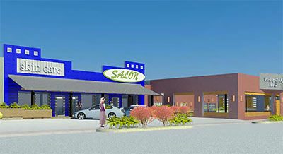
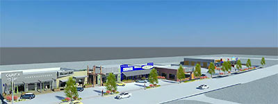
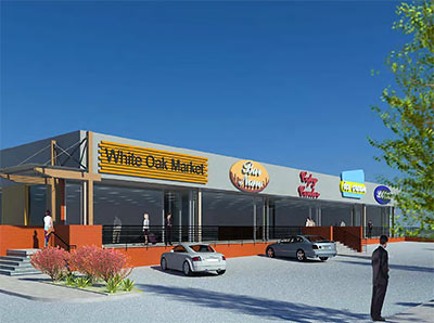
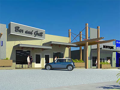
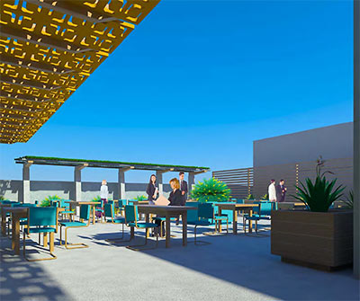
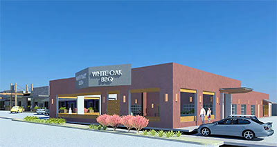
What’s this — another deserted Second Life strip center? No: just a rendered view of Venture Commercial’s proposed new South Heights Retail Center, forwarded to Swamplot by a reader. The 32,100-sq.-ft. project promises to bring together a motley assortment of existing buildings into a single 2.2-acre development, all of its components refaced and decorated using what appears to be the latest in texture mapping technology.
The project is planned for the north side of White Oak Dr. between Studewood and Oxford St., bridging the great spatial and cultural divide between Fitzgerald’s and the Onion Creek Coffee House. The magic ingredient is a new 76-car parking lot on the south side of the street, directly behind Jimmie’s Place.
***
Venture’s marketing materials also refer to the project as the White Oak Arcade, and highlight both the availability of alcohol in the center’s location and its proximity to flood-prone White Oak Bayou:
The site is ideally situated in the wet area between the historic Houston Heights and Woodland Heights
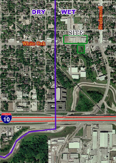
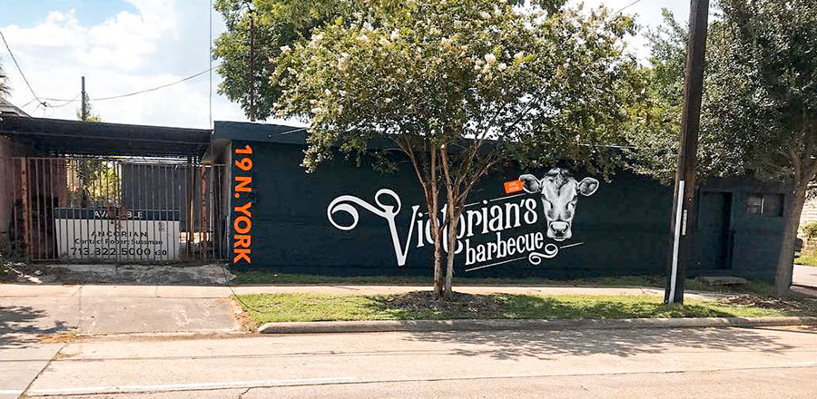
A tiny view of the existing streetscape, which includes the old Heights Camphouse Bar-B-Q:

And a plan of the new design, created by Studio Red Architects:
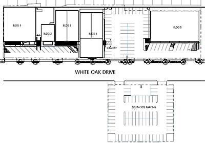
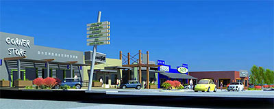
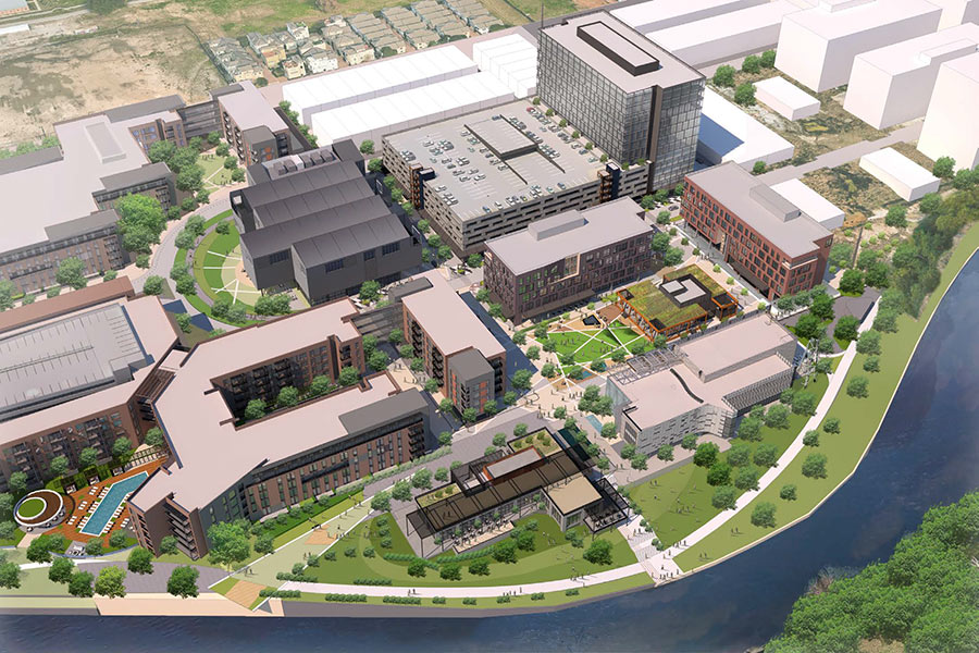
Below: an overall view of the center. The Corner Store is in the center of the block, adjacent to the Onion Creek overflow parking lot.
- The vision behind Venture Commercial [Venture Commercial]
- Philosophy and Approach [Studio Red Architects]
Images: Studio Red Architects



Neat concept to utilize the existing buildings.
Thanks for the news! This sounds a lot more scaled back than what I’d originally heard (large multi-floor new development on the north side, multi-floor parking garage to the west of Jimmie’s on the south side), and for that at least I am glad.
AWESOME!
How can this be awesome? Lets look past the renderings for aminute and see this for what it is .. a strip center. I’m all for reusing the original buildings, although none of them have any architectural merit, but this is similarly without architectural merit.
I would agree that the small scale is nice but beyond that this does absolutely nothing for me at all.
Well, for one thing. Many people like the idea of having more choices for shopping, eating, and other commercial services available to them. Architectural merit is not on their list.
I would argue the architectural merit would be better after the construction versus the current state of the buildings.
Strip centers are not inherently ugly and the Houston consumer, in my opinion, much prefers the ease of a strip center to a mall or a place with a parking garage. According to the renderings, this looks like a stylish strip center. River Oaks shopping center on West Gray is a strip center, but it is lovely. Lots of art deco. On the other hand, the new strip center on Westheimer in Montrose is so plain and ugly and stands out only for those reasons. And for Heights residents, architectural merit is at close to the top if not the top of the list of what we want.
I would not protest any of these existing buildings being torn down for new by their “architectural merit” but I like the idea of “recycling” the buildings and using creativity to make them attractive.
Several thoughts:
1) Yes!
2) While it is a fairly non-descript strip center currently, I don’t find it a devoid of architectural merit as some. Even then, if the developers go bonkers like Pig Stand/Sawyer Sports Bar rehab, then they can make their own architectural merit. Just be sure no Dragon Shirt Boyz and/or Shiny Shirt Brigadiers are allowed.
3) they seems to have gone to some effort to depict the old Heights Camphouse as a BBQ joint. This is just wishful thinking and speculation, but I’ve seen that Ken, the owner of Dragon Bowl/Pink’s Pizza, has started throwing around some promos for a new barbecue joint, Sticky’s. Wouldn’t it be awesome if he had designs on the old CHB? As long as he kept the camphouse potatoes, I’d be down!
I love Pink’s Pizza. I’ll be all for the owner to put up a BBQ place. You can never have enough of those.
I’m completely for it. White Oak has so much promise. That strip of land is completely useless right now. I like that it is not the multi-story building that was first talked about. Anyone know when ground breaking is?
This may not be what some people want stylistically. But I can’t see any reason to discourage or oppose this. Style is, afterall, a subjective matter of opinion.
I agree that stylistically it’s certainly not offensive. I was just hoping for something that would cater better to pedestrian traffic. It’s very easy to cut and paste pedestrians into the front of a strip center rendering with parking in the front but the reality is almost always less suited to pedestrians and more suited to parking. Notice that the renderings don’t include the south side lot either. If you picture the whole development is going to look an awful lot more like a parking lot.
How could this be pedestrian friendly anyway? There isn’t a critical mass of people to go to these shops within a quick walking distance. The area isn’t dense enough to support that much pedestrian traffic.
Sure, there are some people that ride their bikes to Onion Creek and the ice houses, but that doesn’t give reason to withhold parking for the majority of people that will support any new development.
I think this is on the other side of Onion Creek than the planned multi-level multi-purpose RIZK development, no?
True, I’m just looking at the renderings and imagining a lot of tarmac.
On a slightly different note does anyone know why the dry district ends where it does? That line presumambly puts it at Oxford whereas when I look at the original Heights maps they extend one block further. Beverly itself doesn’t appear on the maps but that block of property between Oxford and Beverly does.
There used to be a small lake back there where Beverly begins. So the streets may be a little different from before they filled it in.
I dunno about a lake, but there is a lot on Beverly that has a sizeable ravine in the middle of it that was once landscaped and has tremendous potential. I always would have loved to have had that property to landscape.
That is a really interesting lot. I’ve always meant to go down there after a heavy rain but never got round to it. I don’t know about a lake either, I just know that on the old maps there is an extra strip of homes on smaller lots tacked on the side of the Heights East of Oxford. It is shown on all the old plans that I have seen and extends all the way from the bayou up to 23rd.
When I lived on in the 700-800ish block of Oxford in the early 90s, before the houses were all built back on Beverly, there was a dip in the ground in the field behind my house where the small lake or large pond had been filled in. At that time, there was nothing built on the property. I was told by several residents that when the area was developed there was a small lake (we might consider it a large pond) where residents went and launched model boats (the really old fashioned kind). It gave the area an even more magical and historic feel to imagine. I have never seen anything to document that, maybe it is just folklore.
EMME,
It isn’t folklore. Before developers established the heights and its various neighboring subdivisions, a massive filling project took placed. It was pretty much a landfill for the City of Houston. The area was pretty much wilderness and all the bayous and tributaries were natural.
When the streetcars made there debut in Houston, sprawl from core area near downtown began. The heights was born. Developers had worked with the street car companies. A line existed on Houston Ave and Studewood. I want to say one also existed on Heights Blvd, but I’ll have to look it up again.
Developer clear cut the existing pine forest (the oaks pretty much only existed near the bayous and tribs) and filled in the uneven landscape.
A big example is in Woodland Heights. A 60-inch storm sewer line runs in an old trib to White Oak Bayou. The line is 20-ft below the current natural ground in the area. After the line was built, the natural channel was filled in and streets placed on top. The line currently goes under many people properties and houses and many don’t know it exists. Good news is that the line is in excellent shape. I was part of the project that designed the storm sewer rehab in Woodland Heights. The line is still in service with help from new lines just recently completed.
Outside of that, several ox bows and other trib were filled in. A couple were not though. There is one just east of TC jester where it cross White Oak Bayou south of 11th. It has water in it.
There is another just west of Yale that is dry.
I’ve seen historic photos showing people jumping off the banks of the the natural streams in the bayous in the Clark Pines area (14th street west of Durham). A current development is actually being build on an undeveloped piece of land that was a site of the landfill in this oxbow. The houses are being placed on piles driven deep into the ground to avoid them from sinking or collapsing. I doubt they are telling the home buyers this. Long time residents know about it though.
Jimbo – On why the eastern boundary of the dry area is where it is, see:
http://houstorian.wordpress.com/2007/02/13/the-dry-heights/
Sounds to me like it was based on an early neighborhood boundary.
EMME – There are old topographic maps of the Heights here:
http://houstorian.wordpress.com/old-houston-maps/
The 1922 topo map shows the ravine on the lot on which this proposed parking lot will be built extending north nearly another three blocks just to the east of Oxford.
That is SO COOL!!! Thank you Arlington St.
Thanks for the links Arlington St. The text describing the dry area states that it follows the Eastern edge of the Heights addition South to the bayou. On the 1913 Houston area map here (http://www.sunsetheightshouston.org/images/houston_1913.jpg) the Heights addition pretty clearly extends to what is now Beverly with the City of Houston boundary starting on that line. This would technically put the Western third of this development as well as Charles Liquor and Onion Creek all in the dry zone …. unless I’m reading the map wrong.
Jimbo: I’m by no means an expert on this, but I think the Heights/Houston boundary on the 1913 and other old maps doesn’t reach as far east as a Beverly/Granberry line. And not even as far east as Frasier. If you look at the old Harris County block book maps, and at HCAD maps, it appears that Heights lots extended only 200 feet east of Oxford – putting the Heights/Houston line right along the western boundary of 3106 White Oak (Onion Creek). At least that’s how I read these – let me know what you think.
Block book:
http://books.tax.hctx.net/v021/AE1997_21-22_0017.jpg
HCAD:
http://www.hcad.org/iMaps/Tiles/Color/5358A12.pdf
Unfortunately, I can’t also link to the fold-out map included with Sister Agatha’s book about the Heights.
kjb – You’re absolutely right about the streetcar up Heights Blvd.
(Please delete if this is a dupe comment – I tried once before.)
Jimbo – My read of some old maps (the 1913 map, the block book, the HCAD map, and Sister Agatha’s foldout map) taken together is that the Heights/Houston boundary ran 200 feet east of Oxford around White Oak. Right along the western boundary of the Onion Creek lot. Which would be west of Beverly/Granberry, and west even of Frasier.
http://books.tax.hctx.net/v021/AE1997_21-22_0017.jpg
kjb – You’re right about the Heights Blvd. streetcar. “Houston Electric” is a great book on Houston’s streetcars.
The earliest aerial photos I can find offhand are from 1957, but you can see from Historic Aerials that there used to be what looks like a trailer park back there, on up into the early 1980s.
Cool feature: compare two years, say 1957 and 2004, and drag the red arrow from side to side.
As far as I can tell, this is just the rendering with wishful thinking as far as store names, right? What is going to protect us from another mattress store/check cashing/cell phone mess – that is all that seems to show up in any other strip centers in & around the neighborhood. Is the fact that this is in the wet part any sort of guarantee that we’d get good bars or restaurants? I guess at least it isn’t the multistory nonsense that would have made White Oak as impassable as Studemont now is.
Ha! That trailer park that I pointed out was between 7th and 7-1/2th near Beverly. Coincidentally the Chron just this morning ran a story on one of the last two remaining trailer parks in the Heights, a couple blocks away on 9th, one lot west of Studewood. The 80-year-old landlord will probably have to close down the park and evict her tenants because her property taxes have gotten so high.
Protect us from….? What? I didn’t know matress stores, check cashing, and cell phone stores to bodily or emotional harm. They may not be the most attractive, but if those businesses think that location is good for them, they will try to build there.
How is Studemont impassable? It’s certainly busier, but not bad.
andrea, it will probably start out as sleek hip trendy boho bars, but after the area is no longer the favorite with the fickle 20-somethings that form its target demographic, it will degenerate into the typical ubiquitous Cricket/Mattress Firm/Cash America/generic nail salon strip center.
Who shops at those places, anyway? I went to a check-cashing place once, but only because I needed a money order to mail to someone who was selling me something.
Charles Liquor and Onion Creek are in the dry zone. Liquor by the drink is not served. Beer and wine can be served in the dry zone as can liquor stores selling bottles of liquor not to be consumed on property. Onion Creek has a beer and wine license not a liquor license.
That certainly explains it EMME. It also explains why I never got vodka drinks at Onion Creek. Of course they always have beer specials or mimosas that fill in quite nicely!
Houston was dry when I was a child. That is why bars are called clubs. You had to join a “club” to be able to drink. The country club had lockers each with a bottle that belonged to a “member.” As a member, or a member’s guest, you could share other member’s liquor. Something like that. My parents explained it to me when I was very young, so some details may be blurry (or maybe the blurry comes from Member 542’s planter’s punch)!
I think you’re right about the line Arlington St. It is definitely west of Beverly. Thanks again for more links.
My only complaint about Studemont is the speed people drive and that has nothing to do with there being two storey commercial buildings on it. The speed limit is not double in the middle lane people, not matter how late you are for work.
ArlingtonSt – thank you so much for providing the map link!!
Jimbo – They don’t call those reversible lanes ‘suicide lanes’ for nothing… Given the number of drivers who still try to make left turns from the center lane during rush hour, anyone who is speeding down Studewood is living VERY dangerously.
Arlington St. – Thanks for the map links. Very good stuff.
This is not why I moved to the Heights. Screw teh strip malls and save teh buildings that are there. Spend the money and save the buildings. I do not want to see any of this crap along White Oak one bit. Pure laziness.