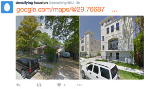
DOCUMENTING HOUSTON’S TOWNHOUSIFICATION, ONE TWEET AT A TIME  While you’re waiting for Kuukibot’s polite but insistent stream of air toxics tweets to come back, another Houston-obsessed account has just hit the Twittersphere — this one documenting the city’s infill development, as evidenced by daily before-and-after shots pulled from Google Streetview (like the 2-house-t0-7-townhome transition shown above, from near the intersection of Gibson and Snover streets in Brunner).  The account’s Philadelphia-based author (who’s looking for submissions, by the way) points to the 1999 changes in minimum lot size requirements as the catalyst for the subsequent waves of tightly-packed townhouse do-overs in previously large-lot neighborhoods around town, as explained by Daniel Hertz earlier this summer: Hertz writes that  the decision to allow lots as small as 1,400 sq.ft. within the Inner Loop (a decree later expanded city-wide in 2013) allowed the building of way more housing stock in the city’s core without a switch to multifamily-style buildings. “An important research project in the coming years ,” Hertz notes, “will be to see if Houston’s willingness to allow more housing—and especially missing middle housing—in the center of a growing metropolitan area can reduce the growth of housing prices and keep neighborhoods more diverse and affordable than they would otherwise be.” [City Observatory] Screenshot of Densifying Houston tweet: @densifyingHOU


Snover is not in Rice Military
Thanks, James! Good catch!
In case you’re interested in that before/after Google street view—it’s here:
https://www.google.com/maps/@29.7668739,-95.4040756,3a,75y,17.62h,94.8t/data=!3m7!1e1!3m5!1swvrLFowRiD1li8YoeOAkeA!2e0!5s20110401T000000!7i13312!8i6656!6m1!1e1
(click the box in the upper left coroner to switch between dates)
oops, meant upper left *corner*
…though “coroner” was oddly fitting!