
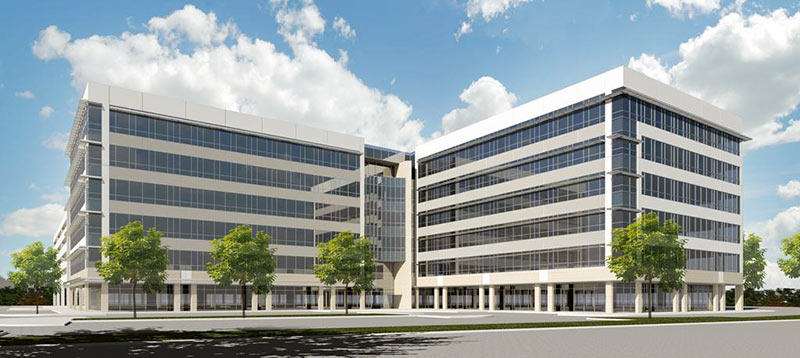
Developer MetroNational is calling the 6-story Energy Corridor District office building and parking garage it officially announced today “the first step in expanding Memorial City north of I-10.” The 240,000-sq.-ft. structure planned for 10100 Katy Fwy. will house 15,000 sq. ft. of retail space on its ground floor — but the rendering of the building designed by Powers Brown Architecture sent out by the company does make the development look like an outpost in an even more suburban office park. As Swamplot reported last week, Mexican building-materials company Cemex will be leasing 80,000 sq. ft. in the complex for its U.S. headquarters.
***
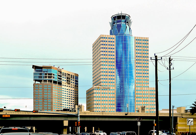
The building is scheduled to begin construction this fall at the northwest corner of Gessner and the I-10 westbound feeder road, directly across the freeway from MetroNational’s no-neck, thorny HQ stuck on the top of the Memorial Hermann Tower (pictured above). Touted as one of the new building’s amenities: a shuttle service across the freeway to the Memorial City Mall and other MetroNational area attractions.
- Office building to rise in new portion of Memorial City [Houston Business Journal]
- MetroNational to bring new office building to Memorial City [Prime Property]
- Previously on Swamplot: What’s Going into MetroNational’s Energy Gateway District, Across I-10 from Its Death Star HQ; What MetroNational Is Stripping Away To Make Way for the Energy Gateway District; Hints of MetroNational’s Energy Gateway District in Conrad Sauer Detention Basin Redo Plans; Meanwhile, Across the Freeway from the MetroNational Death Star
Rendering: Powers Brown Architecture/MetroNational. Photo: Robert Boyd

This is good news. At least they’re using it for something, although I’d like a better looking building.
Yeah that building does look pretty boring…..
Does any else remember the old Memorial City Hospital that used to sit on the east-bound Katy Freeway feeder (west of Gessner)? It was once just a small 3 stories tall. Then they built 3 more floors on top of those, making it 6. Then it kept growing/morphing until it turned into the crazy space alien tower that it is today.
Memorial City Mall has similarly morphed and changed continuously over the past 3 decades, constantly changing its footprint, accessibility, and façade. I would love to see some sort of time lapse of all the changes. With this expansion across I-10, I’m envisioning an eventual network of skywalks spanning the freeway to connect it all, like a great big vampire squid.
An almost identical building was just completed at the intersection of Beltway 8 and Clay, a couple of miles from this site.
@Superdave: I don’t just remember the building. I see it frequently. It’s still standing, obscured by the new construction.
https://www.google.com/maps/@29.78278,-95.546668,3a,75y,194.64h,106.95t/data=!3m6!1e1!3m4!1sWNrFjzFQC22WJSeRVYAE1Q!2e0!7i13312!8i6656!6m1!1e1?hl=en
@SuperDave I also remember both, heck my mom worked at Memorial City hospital in the 80s before it was part of the Memorial system. Everything is still there; it has just been swallowed.
As for the mall I really miss the fountains they used to have there along with the cafeteria; I think it was a Wyatt’s but can not be 100%. One thing’s for sure though, the sign may say ‘Target’ but the spirit of ‘Montgomery Wards’ is still there. Anyone else wonder how long the tiny key place is going to be in the Sears parking lot ?
If they are going ahead with this building, I guess I should finally give up on Luther’s ever coming back.
let’s hope this will be in parcel A seen at the bottom – http://swamplot.com/hints-of-metronationals-energy-gateway-district-in-conrad-sauer-detention-basin-redo-plans/2015-05-13/ and is probably why they worked to get Mathewson Ln into the plan for easier building and hopefully retail access in B, E and C
@Superdave – You can use http://www.historicaerials.com to see aerial shots of Memorial City (and 90% of Harris county) dating back to the 1950s. The Sears was the first structure build as a standalone store in 1962 in what was then Houston’s far western suburb. As you move though the years you can see each of the “wings” as they were developed. Another option is Google Earth (a free install) – use the archive button (the icon looks like a clock with an arrow going counterclockwise) to see Harris county back to 1948 (and various years between then and now). It’s quite interesting to see Houston without freeways and still fitting into an area just larger than inside the (yet to be build) 610 loop.