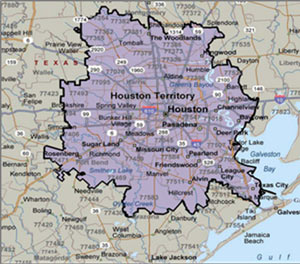
COULD HOUSTON MAKE LIKE WEST VIRGINIA AND LEAVE TEXAS?  In light of the onslaught of global, national, and local post-Brexit musings, Houston Matters’ Craig Cohen takes a
 listen look this week at a few other breakups of historic proportion (from the Virginia-West-Virginia split, to the quashed but perennially resurfacing attempts to pull New York City out of New York). Cohen and a few other voices then ponder the potential for a Houston exit from the Lone Star state: While the conversation seems to suggest that Houston maybe could make it alone, University of St. Thomas professor Jon Taylor rates the chances that Houston would want to leave the state at a solid inconceivable. And the chances of the necessary state and federal bodies being ready to let go without a fight? Slim to none. [Houston Matters; previously on Swamplot] Map of Houston Territory per U.S. DOE EV Project: FHWA
Tag: Political Boundaries
Go ahead and play around with the map above (created by activist Kris Banks), showing the precinct-by-precinct outcome across Harris County for last month’s Republican presidential primaries. Shades of red show the spots won by Cruz (most of them, though a lighter shade indicates less solid support). Precincts won by Rubio show up in shades of blue (mostly clustered on the west side of the Inner Loop), while Trump support is marked in gold (mostly northeast and south of Downtown, as well as strung out along the Westpark Tollway); a few Carson precincts show up in green.
January Advisors’s Jeff Reichmann recently took a look at Banks’s election maps, which include results from both parties’s primaries and a starkly geographically-split down-ballot race for the Democratic district attorney nomination. You can click on each precinct to get its number and a breakdown of the results. Here’s how things looked for the Democrats, with the Sanders precincts in green spangling a field of Clinton blue:

What’s the state of Houston? It’s right here: Fake is the New Real’s Neil Freeman redrew the 50 states, dividing them into parcels of about 6.2 million people so as to distribute electoral college votes more equally. The Lone Star State, this hypothetical map shows, has to be broken up. You’ve got Big Thicket in the middle, with Trinity, comprising Dallas and Fort Worth, tucked inside. Chinati expands up to El Paso along the Rio Grande. And you knew it had to be true: Houston stands alone.
You can see the new 50 states after the jump:

