
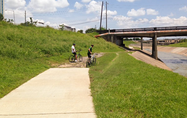
Reader Scot Luther, who claims to have witnessed “wrecks and several flat tires” on a gap in the bayou-side trail along the north side of Brays Bayou just across N. MacGregor Way from the eastern border of Hermann Park wonders why this portion of the several-year-old concrete trail was never completed. Here’s a photo of the scene — where more cautious bike riders regularly dismount for the muddy or bumpy path under the Almeda Rd. bridge. A few hundred ft. beyond the bridge, the trail picks up again on its way to Riverside Terrace.
Photo: Scot Luther
Water’s Edge
It’s the city’s fail safe gap. If the City of Houston were to ever create a complete connected transportation network, the world would indeed implode. Not to say we are anywhere close to completing an efficient and safe connected network, but as long as this gap in the bike trail exists, we can rest easy knowing there will be another day to live, albeit less convenient to the bicycle community.
There is another gap just a bit west of this gap. I’ve never seen an explanation for them.
1 word: Racists.
.
(not really, but since someone is bound to say it, I wanted to be first)
I think the bridge there is going to be replaced in the relatively near future (probably within the next 5 years or so?) as a part of the whole Bray’s Bayou widening project. When they replace the bridge it will change the alignment of the path, so they probably don’t want to spend the money putting in the concrete only to tear it up again in a few years.
That said, I don’t see why they can’t just put in some cheap asphalt to get by for a few years. And there’s precedence for repaving anyway — over the last couple years of work on the bike paths along Buffalo Bayou in Buffalo Bayou Park, there are several places that they’ve put in concrete, dug it up, and put concrete in again (and one place where I think they’ve laid concrete three separate times now over the last three years, for reasons I cannot fathom).
Replacement of the 84-year-old Almeda Road bridge is currently under design, as part of a plan to replace the ancient open-ditch Almeda section with a proper urban avenue. There isn’t enough width to run a bike trail under the existing bridge without cutting back into the riprap and installing a retaining wall… which is a lot of expense to retrofit a bridge that’s about to die. Give it a few years, it’ll be continuous.
Is this bridge scheduled to be redone as part of Project Brays? Maybe the connection is supposed to be built as part of that.
Wish I could post pics in my comment. I documented this gap 2 weeks ago and sent them to the Bike Plan people. Where the concrete ends on the east side of the gap, there is a sheer 8 inch vertical drop in the concrete. It would be dangerous if it wasn’t already completely impassible.
Glad to hear it’ll be replaced in the next few years. I used to ride that trail a lot and was always annoyed to have to go back to the street to get around.
@ Cody. 3 words: the gay agenda.
I ride this trail frequently and have never seen it look as bad as it does now. The poor attempt to asphalt it about a year ago has actually made the entire situation far worse. I am aware there are plans in place to redo the trail when they redo the bridges over 288 in a few years time. My fear is someone will have a serious accident before the rebuild. I actually started walking through this section after my spouse came off his bike trying to cycle through it and both him and bike ending up sliding down the slope heading for the bayou
There is a similar abrupt ending at Stude Park right under Studemont that has been there for a few years too. I guess one day it will connect with the Heights Hike/Bike trail.
Not sure what the problem is, it is a little rough, but nothing as bad as the unfinished stuff off White Oak. I always get a kick out of riding through it with a baby trailer while others are off and walking. The picture above shows guys on mountain bikes, kinda sad.
We had this discussion on our Nextdoor list last summer:
“A bit of HX, as best I have collected. HCFCD did not complete the trails under the Almeda Bridge because the bridge was to be reconstructed by CoH in connection with TxDOT widening of Almeda, four to six lanes, Loop 610 South to MacGregor, (legally TxDOT state owned FM 521). TxDOT has cut back the length of their project due to funding shortages. I do not know the current status. Doreen Stoller, Executive Director of Hermann Park Conservancy shared information last February 15 with a group of cyclists including Michael Skelly, TX State Senator Rodney Ellis, Metro Board member Christof Speiler, and many other advocates that HCFCD relinquished control of the dirt under the Almeda Bridge to CoH. Shortly thereafter, I wrote a letter to Mayor Parker seeking clarification about the Braes Trail under Almeda Bridge. Edna Kraatz, C.P.M., Division Mgr., Engineering and Construction Division, PW&E, wrote that, “At this time, the Almeda Road Reconstruction from MacGregor to Old Spanish Trail has been suspended due to lack of funding from Harris County Flood Control District”. Don’t you just love “guvment”. Keep the letters going!”
And
“I am sorry it took me so long to respond. We are just as upset as you with this trail that was not completed. There is a solution, good new but it will not be completed too late 2015 or early 2016. This missing portion of the trail is being combined in a grant package that Houston Parks Board has to resolve the missing trail issues at Holcombe and Cambridge intersection.
I am sure not the answer you were looking for but we are certainly aware.
Sincerely,
JT
[Joe Turner]”
And
“I talked earlier this afternoon with Deotis Gay, the Road & Bridge Operations Superintendent for Harris County Precinct One. Previously, Deotis reported the hike and bike trail under the Almeda Road bridge is not scheduled to be funded until 2016 and constructed in 2017 by the Houston Parks Board. Today, he reported on a recent meeting with Richard McNamara, the Bayou Greenways Program Manager for the Houston Parks Board, where they inspected the stretch under the Almeda Road bridge.
Deotis reported they will proceed in the next couple of weeks to implement a temporary fix on the north bank of the bayou using some recycled materials to connect the paved hike and bike trail from the west side of Almeda to the paved hike and bike trail on the east side. Once started, Deotis estimated the work would be completed within a week.
Although I’m not sure what this interim trail under Almeda Road will look like, I’m sure it’ll be an improvement over the current ruts. And it may be in place by late September or early October!”
The gravel fix mentioned in the last post above from September 5 was completed, but washed away after the next heavy rain a few weeks later.
HoustonReader: lol. Forgot about that. It for sure ties into the gay agenda.
HouCynic- I’ve heard rumors that Clark’s Hardwood Lumber owns the property that the path would have to cut through. Maybe someone could verify this?
Here is a website:
http://houstonbikeplan.mindmixer.com/
that allows you to post comments or tag an area of a map that the City will use as they develop the new bike master plan.
I am a member, but not in the management of Bike Houston, which is supporting this effort. I do not work for the city.
PLEASE go there to make yourself heard. PLEASE go to one of the many public meetings that are being held around town to gather comments that can then be put into the plan. It is almost as easy as posting a comment on Swamplot!
@j, it appears from HCAD maps and data that Clarks does indeed own the property to the middle of the bayou. That’s the same issue that kept the trail South of 11th stalled for some time, with the result that it was moved to the other side.
Houston Parks Board will be filling in this gap in the trail along Brays Bayou under Almeda (and several others near Hermann Park) as part of the Bayou Greenways 2020 project, with a grant from Texas Department of Transportation (TxDOT) and additional funding from the City of Houston and private donors.
Construction of the new (concrete) trail on the north side of Brays Bayou should begin in the fall of 2016.
In case you’re not familiar with the project: Bayou Greenways 2020 will create a continuous parks system with 150 miles of hike and bike trails along Houston’s major waterways, including Brays Bayou. The Houston Parks Board is leading the private fundraising of $120 million and managing the acquisition, design and construction of the Bayou Greenways 2020 Project. Bayou Greenways 2020 was made possible by Houston voters who supported the “Parks by You!†city bond referendum of 2012.
Feel free to reach out to us with any other questions.
–Catherine B, Houston Parks Board Communications Manager