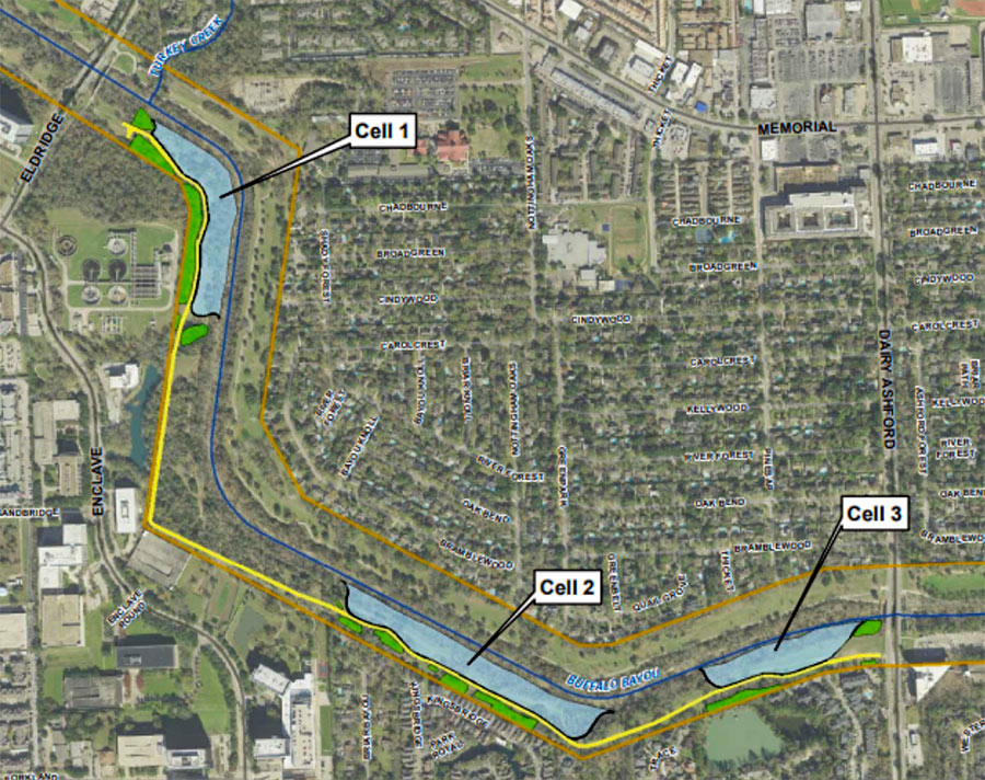

Time’s almost up for a whole mess of trees lining the south side of Buffalo Bayou between Eldridge Pkwy. and Dairy Ashford (pictured at top), where the Harris County Flood Control District plans to construct the first 3 of a series of overflow basins. Removal of vegetation across the bayou from Nottingham Forest’s southern border is scheduled to begin within a few weeks; construction company Lecon has the $1.8 million contract to build the “linear stormwater detention compartments,” which are meant to accommodate a temporary visit of up to 90 acre-ft. of bayou water during a flood.
The trees and basins will be carved out of Terry Hershey Park. The district notes that some trees and vegetation may be preserved — forming a buffer “where possible” between the basins and private property to the south. Large sections of the popular Anthills Mountain Bike Trail, which the district notes “were built on publicly-owned land without written permission and without compensation to the public” will be cleared, though a portion that sits between the 2 westernmost basins will remain.
***
Later construction will add more basins on Flood Control District-owned land along the 6.4-mile stretch of bayou between Hwy. 6 and Beltway 8. Similar detention is already in place on the north side of the bayou, from Dairy Ashford to Wilcrest.
The new basins “would not have likely prevented flooding in Hurricane Harvey or a similar weather event,” the district notes, but “it would reduce damages from more frequent storms and would serve to increase our defenses against flooding during larger-scale rain events.”
Slowing and retaining stormwater before it reaches the bayou would be a better and less expensive approach, notes nonprofit advocacy group Save Buffalo Bayou, which opposes the project: “Allow the bayou to restore its natural meanders, naturally lengthening and increasing the capacity of the stream, which is what it will keep trying to do anyway, eating away at the banks long ago weakened by artificial straightening as well as by ongoing digging and compressing by heavy equipment. Instead the county and the district spend millions repairing the unstable channel in order to keep it straight.”
- Removing Trees on Buffalo Bayou Because It’s Cheap and Easy; Flood Control Sends Notice to Residents Adjacent to Terry Hershey Park [Save Buffalo Bayou]
- F-58 Linear Stormwater Detention on Buffalo Bayou; FAQ; flyer, [HCFCD]
- Previously on Swamplot:Â Stop Trying To Fix Buffalo Bayou, Says Save Buffalo Bayou
Photo: Save Buffalo Bayou. Map: HCFCD


I hope these detention pools make a difference but I doubt they will: Less likely since the rooted greenery is being removed.
Flood events will always tear up a riverbed and its plants. The best thing to do is to let the vegetation grow up until the next flood event – that’s the cheapest most efficient tactic.
If a future flood event takes people’s back yards away then that’s just tough for those homeowners.
In spots, Buffalo Bayou is a lovely, primeval, place to take a canoe trip. In spots it’s a trash heap. It’s always interesting though!
Love how the view is, it doesn’t matter that the anthills are Houston’s best and most popular mountain bike trails. Always busy with people enjoying a small patch of nature. The justification is that they don’t have written permission…
Hello!
F written permissio. your citizens the proof and are enjoying the land. Demand your designers to challenge there thinking and and leave the anthills, make it a city park, build a parking lot for them and rearrange one cell. Win win.
Usual, square thinking, lack of focus on quality of life that keeps Houston off any best place to live list… we can do better
The people should know not to make the people’s park more enjoyable for people without using the people’s money.
— HCFCD, probably
Only 90 acre feet of new detention? For $1.8 MILLION? LMAO as if that tiny amount will make ANY difference during a flood, but the graft that is associated with working for the government is on full view.
The trees almost always lose. Hence, global warming.
Wonderful, let’s destroy more green areas and keep cutting trees down!
There is no “detention” in the design. No water will be held “temporarily”.
The basins will be wide open. It is basically a wide channelization.
Strange they don’t highlight the study reported channelization only potentially reducing the water level about an inch over a small stretch over of the bayou.
This stretch of now relatively mature riparian forest is beautiful and the eradication of tree canopy will be an unnecessary loss.
:( this hurts
The people of this area said that the area had never flooded before Harvey, and then it flooded because the Army Corp of Engineers opened the reservoirs. If the reservoirs are deepened and more retention added then why do they feel the need to destroy parkland immediately downstream from the dams? Obviously, there is too much money to spend and relatives and close friends of the planners want the construction job/money
Should organize to stop this. Have been riding ant hills since 1994. People who do not frequent this stretch of bayou may not know its beauty or usefulness but will be an irreplaceable loss of being able to enjoy the outdoors in houston if allowed to go forward.
A total waste of taxpayers $$$$. Example: the “re-working ” of Brays Bayou in Meyerland. HCFCD screwed up big time. Did the upstream work first.Waited to do the Meyerland section(s) of Brays Bayou until hurricane season.And viola. Harvey struck and flooded all of the equipment and “improvements” into the Ship Channel !!
“were built on publicly-owned land without written permission and without compensation to the publicâ€
.
seriously, these are fighting words. God forbid residents take it upon themselves to add value to the city and expand on local businesses and tax re-capture for the city. SHAME ON YOU.
Terry Hershey is rolling over in her grave.
@Turning_Basin… re organize… what could show people who cannot travel there, or have the time, would be a video… maybe someone reading this with video making/editing skills could make one and share it on the social platforms… including here in Swamplot! :)
I agree about the beaut;, I recall first seeing it by ‘accident’ years ago, before trails were even put in… when I was in better shape and used to run along the bayou!
Lugubrious: ridiculously sorrowful – that one word sums up the collective mental giants “in charge†of this city’s flood control.
Deepen the freakn reservoirs! period.
Probably the best and most accurate description yet of what HCFCD is planning. They’ve called them “detention/retention” ponds over and over. But if they do like they did on the north side, they are actually overflow ponds. They won’t slow water getting into the Bayou, only give it a place to go when the Bayou can’t handle it anymore and it overflows. And remember, the main reason this is being done is so City of Houston can pour more water into the Bayou from future developments. Screw the citizen hikers, bikers, walkers, runners that use that area daily. Screw the wildlife. Screw the local residents who have opposed these plans for years and years. But most of all, screw Terry Hershey who would be having a fit right now if alive.
To correct the quoterd politicians, the trails were built by public taxpayers on public land for public use.As there was no cost and contractors there were no kickbacks to politicians. Now we lose good outdoor recreation and a natural oasis in this part of the city. Will impact thousands of vores for sure from hikers, environmentalists, cyclists, trail runners and more! Time to clean house and stop these type of projects.
Throwing money away attempting to control a bayou that floods several times a year makes as much sense as having a city where the sidewalks are privately maintained.
The funding for these projects needs to be stopped.
One of Houston’s biggest liabilities as a city is a lack of outdoor recreation. Besides Memorial park, the Antills side of Terry Hershey is the only place you can go in the city and still feel like you are in nature. And they are destroying it all for a trivial amount of flood control and a few sweetheart construction contracts. They say the public wasn’t compensated when the trails were put in, but where’s our compensation for the forest that can never be replaced? They paved paradise and put up a storm water retention basin.
So when is the Farewell to the Forest party?
Wow. RIP Anthills. I kinda figured that Harvey would kill the Save Briar Forest or Ashford Forest movement or whatever it was called. HCFCD has been eyeing this property for a long time. Who is the quote associated to. It is insulting. The good news is there will still be enough preserved forest for a few small trails and the basins themselves can be utilized to some extent. Of course, only if a rebel member of the public has the audacity to build them without written permission and without compensation to the public.
Other states have realized they need to keep the trees as part of flood control. https://extension.psu.edu/the-role-of-trees-and-forests-in-healthy-watersheds