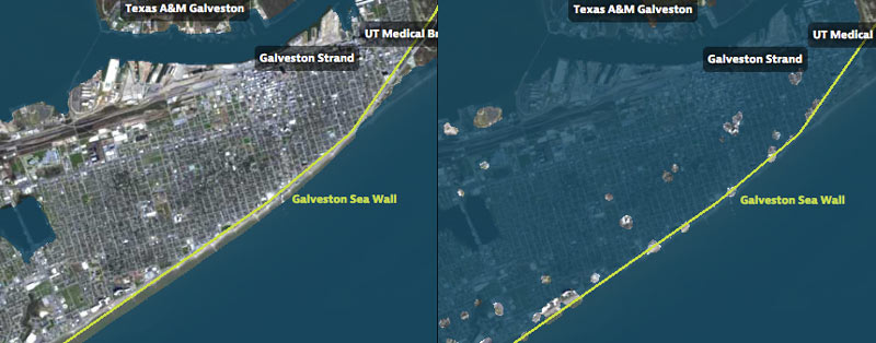

That’s Galveston Island going for a dip in the before-and-after captures above, from a set of interactive timelapse maps released by the Texas Tribune and ProPublica yesterday (along with several articles by authors Kiah Collier and Neena Satija). The new maps model flooding across the Houston region during Hurricane Ike — as well as what would have happened if Ike had actually hit just south of Houston, as meteorologists initially expected.
The maps are your chance to relive an old disaster, or to see how many of your neighbors you can take out with a hypothetical-but-not-unrealistic future storm: users can pick between Ike, south-er Ike, a storm 15% stronger than Ike (nicknamed Mighty Ike), and a modeled 500-year storm (which the article suggests may actually be a concern on the every-few-decades-or-so level; ‘500-year’ has always meant ‘a low probability in any year’, and climate change is shaking up old modeling assumptions). The graphics also include a few dramatic face-offs:Â Mighty Ike and the 500-year storm VS. 2 of the miles-long multi-billion-dollar coastal protection projects being studied for the upper Texas coast.
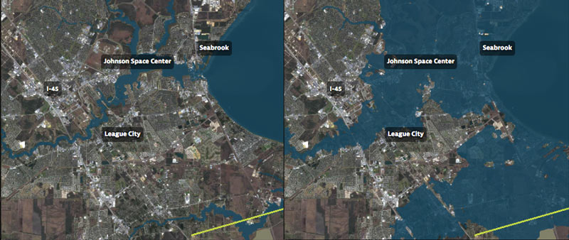
You can even search for your home address in the map system to see what flood levels might look like in your own back yard. Here’s what the maps show happening to the Clear Lake, Seabrook, and League City areas at the peak of the 500-year storm model’s storm surge, which the article says is a “not if, but when” event:
***

In the after scene above, Clear Lake spreads out along the paths of Armand Bayou, Taylor Lake, and Clear Creek, giving Johnson Space Center a bath along with many residential communities. A study by Texas A&M professor Sam Brody showed that nearly half of the people living in the 100-year flood plain in the area are unaware that they do — despite the fact that federal law requires those same residents to buy flood insurance. Brody believes that people moving to the Houston area who “haven’t grown up with hurricanes” might not take the notion seriously.
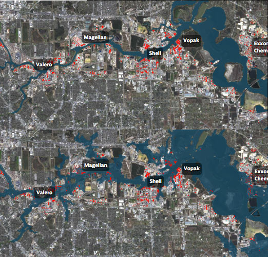
The maps also zero in along the Port of Houston and Ship Channel, where thousands of chemical storage tanks are considered vulnerable to flood damage. Also mentioned are the estimated 300,000 people who live in nearby areas (including parts of Pasadena, Deer Park, Manchester, and Galena Park) that could be greatly inconvenienced by a spill from one of those tanks during heavy flooding.
Other possible outcomes of a storm causing weeks of Port and plant shutdown? Major supply chain disruptions for products ranging from jet fuel and prescription pills to airbags and tennis balls.
The authors note that a full count and map of chemical storage containers is not maintained by any government agency; tanks identified by the modelers from “dots” in 2008 aerial photos are marked in red in the before-and-after of the Ship Channel below:

It would only take a leak from one of those tanks, UH’s Hanadi Rifai tells the authors, to turn the Ship Channel into a “dead water body,†greatly disrupting the ecology downstream in Galveston Bay.
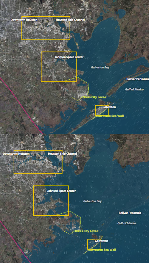
Here’s a before-and-after view of the whole region after the predicted storm, showing Galveston Bay defeating Galveston Island, the Bolivar Peninsula, and much of Texas City:

- Hell and High Water [Texas Tribune and ProPublica]
- About Hell and High Water [ProPublica]
- How We Made Hell and High Water [ProPublica]
Images: Texas Tribune


I’m moving to Austin!!!
This is interesting because the mayor was mentioning the other night that they would be moving towards remapping flood zones in the next few years. If this is true, insurance premiums could be headed up for a lot of people. Especially the refineries.
Great resource, I live in Houston’s East End neighborhood and I’ve been wondering why my property insurance was so high!
@Mike property insurance doesn’t cover floods. You need separate flood insurance and that’s getting more expensive because it’s been subsidized by the federal govt since 1968 and is now broke. They’ve been trying to move the rates to a more market rate system that would cover the cost of claims.
Cool tool but don’t rely on the address part as it takes the average of ~20 acres in that area. Had 15ft confirmed surge at bay house and map says 3.9ft surge when I type address in. For the Ike+15 mph south of Galveston put us over 10 so realistically looking at 30+ft worst case.
NOW YORK CITY