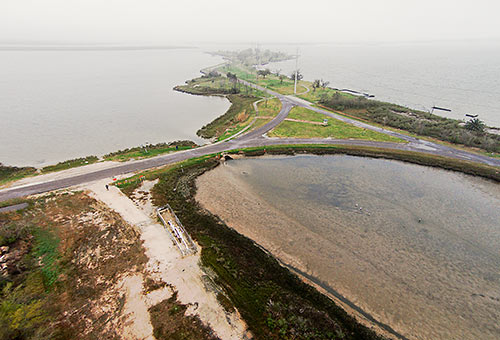
Here’s some raw footage from a camera-wielding drone flight landscape artist and researcher Steve Rowell piloted earlier this year over portions of the Baytown Nature Center, the Crystal, Scott, and Burnet Bay peninsula that not too long ago was the home of the tony Brownwood subdivision — before it got all sinky and decided to subside 10 or so feet into the water. In some portions of the video, you can still spot the occasional home or garage slab from a fifties- or sixties-era rancher or 2, not to mention concrete broken up from other foundations and driveways and recycled on-site into surge barriers that now control the more recent, court-ordered wetlands environment.
***

Tourists visiting the area these days mostly focus on the birds, and try to ignore the pipelines running through the place; Rowell’s drone gets a little shaky at times, but manages to steer clear of any aerial interference.
Footage and stills from his Brownwood reconnaissance, as well as images and recordings grabbed from other curious sites in the local landscape, will appear in a 5-day “visual and acoustic installation” in the Bermac Arts Building in Midtown opening tomorrow that Rowell put together for the Counter Current festival, run by UH’s Cynthia Woods Mitchell Center for the Arts. Rowell’s work also appeared in the big exhibit on Texas Oil that the Center for Land Use Interpretation set up at UH in 2008.
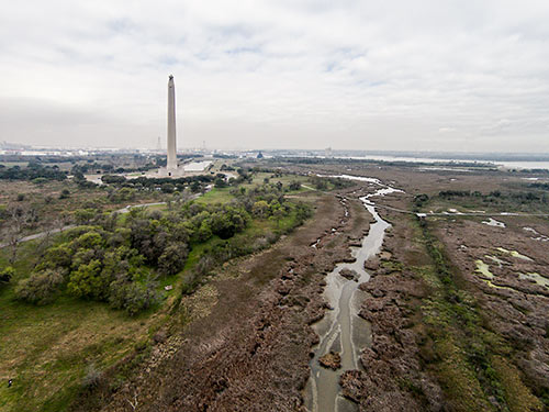
Here’s a bonus shot from another Rowell drone flight, of a more familiar monument just across the bay and Ship Channel:

- Uncanny Sensing (Texas Prototype) [Counter Current]
- History of Site [Baytown Nature Center]
Video and photos: Steve Rowell


Was this video shot with a drone and that fish effect is so dumb. It is really cool to see this area
I love reading about Brownwood history. I think it’s fascinating that a neighborhood that was so nice at one point does not exist anymore. Here’s some links for anyone that wants to read more about it.
Larry Albert from Rice presented his dissertation on Brownwood. It’s my favorite about the subject. http://www.rice.edu/~lda/wet/bwood/scene/index.htm
http://www.rice.edu/~lda/wet/remote.htm
Texas Monthly from 1974 – http://www.texasmonthly.com/story/disaster-part-two-houston
Nine min. YouTube from 1985 – https://www.youtube.com/watch?v=_z3h9msToY8
Houston Chronicle from 2013 – http://www.houstonchronicle.com/news/houston-texas/houston/article/Brownwood-The-suburb-that-sank-by-the-Ship-4379765.php#/0
Cristan Williams blog from 2011 – http://www.cristanwilliams.com/b/2011/01/21/can-a-ghost-towntoxic-dump-become-a-park/
Brian.
http://gopro.com/support/articles/curved-nature-pictures-videos
Read. Wide angle lens.
At 13 seconds in, those houses across the water at the top of the frame are at the end of my street, South Burnett Drive, in the Lakewood subdivision. The street rises gradually as you travel away from the water, but the low end of the street lost over 20 houses during Hurricane Ike. Some owners have rebuilt on pilings, some have rebuilt at grade, and others have abandoned the property. (My own house is further up the street, at about 31 feet elevation.) The end of the flood debris field from Ike was about three lots south of my house. So, while the name “Swamplot” is amusing, to some of us it is no joke.
I lived there from roughly `79 until about `86. My grandparents bought a house on Cabaniss street in 1945. They were the last house on the street. After Alicia they were again the last house on the street. The older, less affluent part of the neighborhood survived with the truly wonderful houses along the water destroyed.
That is an interesting spooky place. Some of the slabs have tile attached: a pink bathroom, a green bathroom
Brownwood was well into decline long before Alicia. I rode out the first few hours of the hurricane in roughly the same spot in opening shot of this video. I moved to the opposite side of town when it was obvious that I’d soon be a goner.
I lived there on Mapleton before hurricane Carla hit….it was truly a beautiful place.
thanks exxon for pumping the life out of a wonderful place!!
.”thanks exxon for pumping the life out of a wonderful place!!”
It was the groundwater wells more than the oil wells that caused the subsidence. Exxon, Humble Oil back then, wasn’t the only one pumping groundwater for their own use. The cities of Baytown, Pelly, and Goose Creek all got their water out of the ground not to mention all the other towns and industrial sites along the channel. Just saying that Exxon sank the subdivision is grossly oversimplifying it.
Pretty sure I had relatives by marriage that lived in Brownwood off Bayshore dr for years, the Jasper family. I visited once as a child in 1974. . They moved out way before Alicia probably during the mid 70s . Wish I could get more history but most everyone has since passed away . I do have 2 good pictures of the backyard in 1972 with the monument in the background