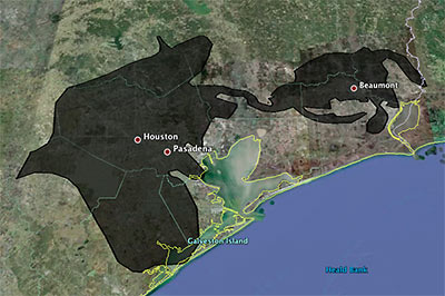
Playing around with a super-fun online tool that lets you superimpose the blobbish outline of the 2500-sq.-mile (and growing!) Gulf of Mexico oil slick from the Deepwater Horizon offshore-rig disaster onto various cities, Houstonist editor Marc Brubaker tries it on Houston — for size.
“It’s almost creepy how the slick follows I-10 out to Beaumont,” he comments. Of course, Brubaker should have nudged the oily blob a bit more to the east. Sure, he might have lost a few of those shiny exploration-company offices that have fled to the western stretches of Katy that way, but you’d be picking up lots of fun storage tanks and chug-chugging industrial plants at the northern reaches of Galveston Bay, and you’d get better coverage of Texas City, too.
Oh — but the outline is only up to date as of May 6th? Maybe we’ve got full coverage by now, then!
- Slicky Situation: The Deepwater Horizon Spill’s Actual Size [Houstonist]
- How big is the Deepwater Horizon oil spill? [Paul Rademacher]
Image: Houstonist


Thanks for the nod, folks. Also, it’s a bit hard to drop the overlay in a more precise spot – you can’t just drag it around the map.