
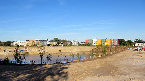
A reader sends in pics showing how construction is progressing on the 3 retention ponds along White Oak Bayou TxDOT is building between Yale and Shepherd — and hoping to trade them for any available updates about plans for the adjacent segment of the planned bayou-side path: “Looks like they are making progress with tree planting and installation of pavers on the slopes. They have left a wide swath of level ground around the entire perimeter. They are still doing earthwork on the north end, and it looks like they still need to excavate more soil from the center pond, but you can make your way around all three detention ponds.”
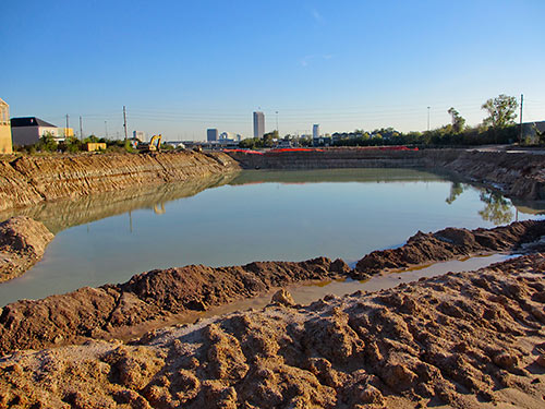
The photo at top shows the center pond (south of the bayou), looking northeast, with White Oak Bayou barely visible off to the lower right. Below, a view of the northernmost piece, Rutland Pond, a portion of which interrupts 6th St. (where the orange construction fencing is visible):
***
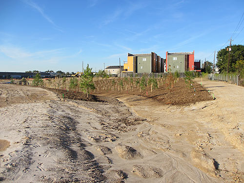
And here’s a view looking north, with the future trail on the right side:
Now about that trail: “I saw the post about replacing the burned up railroad bridge, west of here. Have you heard anything about the future trail along White Oak, from Shepherd to Yale? I have only been able to find online schematics from early 2013, that indicate it is proposed and unfunded.“
- Previously on Swamplot: Here Comes More Greenway Mileage for White Oak Bayou, What’s the Story with Rutland Pond?
Photos: Swamplot inbox

retention or detention?
A detention pond would be much more entertaining. “Do your homework or go sit in the detention pond!” “But there’s mosquitos in there!” “Then I guess it’s an easy choice, then, isn’t it?”
Detention!
The layperson would say retention, but in the water district world it’s detention.
I live right next to White Oak Bayou where the trail you are talking about is planned. I have spoken with the Houston Parks Board many times about the trail since I moved here last March. I met with them over the summer about their plans for the trail. I have some blueprints for the section that will occur east of Heights Blvd. My understanding is that the trail construction will start in the Spring of 2014. They also said that demolition and construction of the burned out bridge section would start in the Fall of 2013 so I take that date with a grain of salt. They told me that they are not the best at updating their website Houstonparksboard.edu. The trail is supposed to continue from 11th street down to the Heights trail near I10. It will loop around the bank then connect up with Stude park via the Heights trail bridge. They plan on having street connections for the trail at Yale and on the East side of heights.
*houstonparksboard.org
It’s actually neither a detention or a retention pond. It’s actually floodplain compensating storage. As part of the project, TxDOT is removing the depressed section of I-10 out the floodplain by putting in a pump station with backflow preventers to keep the bayou out. Since this storage is no longer available to the stream, TxDOT has to add these basins.
They are offsetting for what they took out of the floodplain.
There is also a large detention/retention/floodplain storage pond just east of the TC Jester bridge over White Oak Bayou that is nearing completion. I think all of this is part of the I-10 flood prevention project. DId anyone go to the Parks Board ‘groundbreaking’ a month or so ago at the burned-out railroad trestle?