
WHAT COULD GO UNDER WHEN I-45 MOVES UNDERGROUND AND EAST OF DOWNTOWN 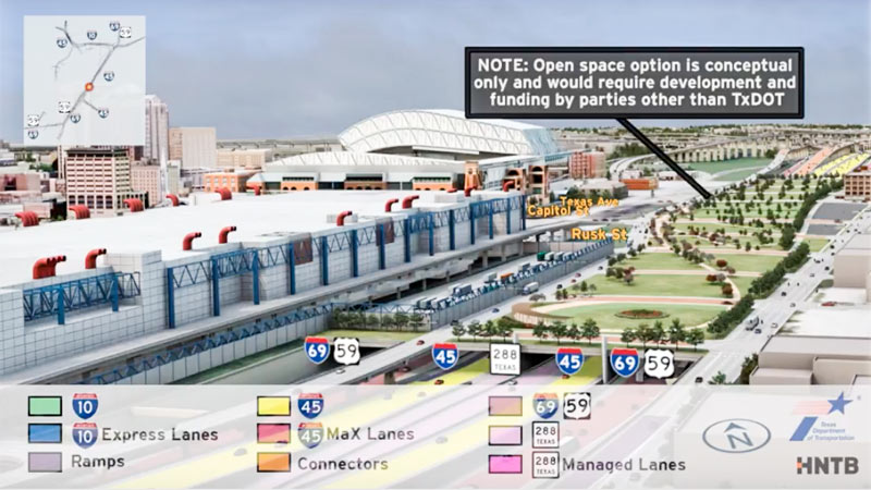 Jeff Balke tallies some of the expected carnage just east of Downtown should TXDoT proceed with its planned rerouting of I-45 from the west side to the east side of Downtown, widening the path of that stretch of Hwy. 59 (aka I-69) to Saint Emanuel St. Among the establishments expecting to have to shut down or relocate as a result of the expansion: the Bayou City Barber Shop, Vietnamese restaurant Huynh, Ahh Coffee, Tout Suite, one building of the Ballpark Lofts, low-income housing development Clayton Homes, a couple of nonprofits, SEARCH Homeless Services’ new building, the Loaves and Fishes soup kitchen — plus other assorted bars, barbecue joints, artist spaces, and office space. Among the questions Balke keeps hearing in reference to plans to put this portion of a new I-45-69 combo below grade, possibly (only if separate funding can be found) with a greenspace “cap” planted on top of it: “why [would] a freeway would be constructed lower than street level in a city that floods with seeming regularity, particularly when the highway in question is a hurricane evacuation route? TxDOT is quick to point out that we already have roadways below grade throughout the city that have not suffered major flooding problems since Tropical Storm Allison in 2001, which broke records and is widely considered a 500-year flood. Still, flooding is something the agency appears to have taken seriously. ‘No matter the situation, there’s a potential for flooding,‘ [TXDoT spokesperson] Perez explains, ‘but with anything below grade, additional pumps and detention ponds come into play.’ [Houston Press; previously on Swamplot] Rendering showing possible park behind GRB: HNTB and TxDOT

Meh. If you live in a car-centric city you should expect things like this. At least there is no real architectural treasures being lost this time around.
Lesson to be learned: Don’t build large buildings or establish businesses adjacent to expressways. Wait a sec …. Doh!
I guess Minute Maid Park would also lose Lot B?
OK so it will flood. Aren’t evacuation routes supposed to be used before a hurricane or TS hits?
Just tear down Pierce Elevated and replace it with an at-grade boulevard–no need to waste money and destroy neighborhoods by building a new section anywhere. It won’t help with traffic anyway so what’s even the point? Other states wised up and stopped building freeways near their downtowns DECADES ago. I have no idea why TxDoT has to be so backward and foolish.
This seems more like a project to keep bureaucrats with something to do as opposed to something that will actually happen.
Take that small businesses. You can rest assured that the state will NOT provide you with proper compensation for your efforts and entrepreunerial spirit.
.
@HouCynic, agreed, the same question could be offered in reverse, why would you NOT want a massive freeway that would otherwise be empty in the event of a true emergency to flood? Spend the money on barriers/signage for flooding, throw in some pumps and you have a perfect deterrent for neighborhood flooding in the event of an emergency. I don’t remember any of the surrounding areas along 59 complaining about it being a great place to store flood water during Alison.
Oh good grief, the “we can’t build such and such here because it floods” BS excuse. If these idiots are so worried about flooding, they should really go ALL the way, starting with Houston’s obsession with massive concrete lots which cause runoff, which makes street flooding worse. Crickets I’m betting. Too many double standards. There are more valid reasons why this project shouldn’t happen, like the many businesses and residences that will have to be demolished to make way for the expansion. As for that expensive green space cap, you can forget it ever being built in our lifetimes, if at all. TXDOT will say anything to sell this crappy rerouting project because they know it’s a hard sell with the general public and the EaDo/East End districts.
@Ed: That greenspace will totally be built, just like the last one: http://imgur.com/a/2izgj
The East End loses so much with this project. We’re losing small, independent businesses that have finally started to open on this side of town after years of nothing and we’re losing the Polk connection into downtown, which means Leeland is the only direct route into downtown for those of us that live a little deeper into the East End. All this so that people in League City can drive up to The Woodlands.
I thought coastal evacuations occur PRIOR to hurricane landfall? Why should we care if the sunken freeway that serves as an evacuation route floods after everyone has evacuated?
This is a huge gain for Eado, not a loss! Rebuilding below grade would eliminate the massive freeway barrier between the convention area and Eado. This project is old news, so any news recent new business should of taken this risk into consideration. And I like the idea of below grade freeways as an emergency flood water detention system for the extreme emergency situations.
Seems that a few people have already forgotten that Houston sometimes experiences surprise flooding events. A section of Allen Parkway (the Montrose underpass) flooded last Saturday. Leaving the flooding likelihood aside, though, this idea of relocating I-45 is as worthless as building that stupid wall. The resulting park area will just become a campground for the homeless, leaving the city right where we are.
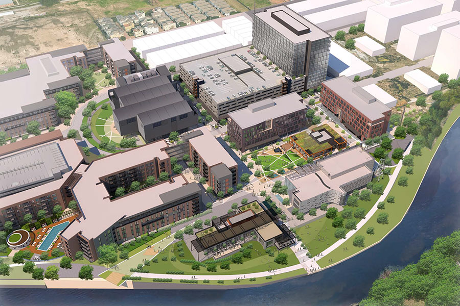
TxDoT is accepting comments until July 27. Please send comment if you are unhappy with this plan. The flyover video on the website is helpful for seeing the scale of this project. The maps were hard to decipher (for regular mom types). Living on this side of town, it would be a shame to have existing and recently developed amenities (which were a long time in coming) wiped out. That, and the irony of having +20 lanes of pavement right behind the “green jewel” of Discovery green. The rendering shows optional green “park” space on top of 6 blocks of concrete emptying into a 5 lanes of feeder for a reworked St. Emanuel. It will further isolate a neighborhood with limited access to most items.
“.. FOR REGULAR MOM TYPES”?
What type of sexist troglodyte are you, Woodleigh Living? Such comments prove you are not only ignorant but live in the distant past where men wore animal skins and beat their breasts in a primal display of make believe self-importance.
my big question is what will become of the green/purple lines if this horrendous plan goes through?
So one stated benefit of moving I-45 is that demolishing the Pierce Elevated will “free up” land for development. But the Pierce takes up only 12 *half* blocks. The new plan obliterates 20 *full* blocks, a net loss of 20 acres (blocks are 250′ square). How is this a benefit?
Plus, that green space / cap is nothing but an empty promise. TxDOT even says they won’t pay for it, in the coded language of “we’re happy to partner.”
“my big question is what will become of the green/purple lines if this horrendous plan goes through?”
According to TxDOT’s schematic, they’ll share a bridge with Texas Avenue across the newly-submerged freeway.
How about a referenced? Cannot go anywhere without road blocks blocking and detours. Find an alternant route to work and they tear up and block that. TxDot has our city looking like a war zone! 290 is a parking lot of traffic. Until they finish this project do not start a other! Many of these expansions do not help like Beltway 8 behind Jersy Village. I’m mad too, Eddy!
Referendum how about a vote this?
@WR – Please, chill out. Woodleigh Living was stating that she is a “regular mom type”. As a woman, I do not find this remark sexist or misogynist. Find something else to complain about.
just another one of those deals where people complain then when it’s finally finished everyone agrees it’s so much better looking and improves the area…this is a fed interstate so it’s gonna get done.
By tearing down the entire block between St. Emmanuel and Chartres, TxDot will not only destroy entire businesses, houses and nonprofits, but will also damage entire neighborhoods (EaDo/East End districts) that have struggled a lot during year to finally find a way to develop and attract people and business to them. A 10-15 year project will represent the dead of rising neighborhoods. The park on top will never be built and the area will be full of homeless people.
place your comments to TXDOT by July 27th here: http://www.ih45northandmore.com/
Hopefully lessons learned from a similar project in Boston (The Big Dig!) are considered. Regardless, I am suspecting it will proceed and a park will be built with great views (= increased property values) of the park from adjacent properties once all is completed a decade or so later.
https://www.bostonglobe.com/magazine/2015/12/29/years-later-did-big-dig-deliver/tSb8PIMS4QJUETsMpA7SpI/story.html
Thanks Gloria Steinem and let me clarify WR. Myself being a “regular Mom type” and not having an engineering background, I found the maps attached to the TxDoT website to be nearly indecipherable. All-in-all, the website is so confusing that you would almost think the intention is to obfuscate. Download any one of these maps and take a peak. http://www.ih45northandmore.com/
I’m curious what the lack of a bridge will mean for the homeless population. Will they stay or move on to more shaded areas?
I hope they know what they are doing by putting I-45 underground. To me, that doesn’t sound like a good idea.
I def don’t think putting I45 underground is a good idea.
I’m with Christian that highway traffic should circumnavigate the city center; Local drivers who exit will be on surface roads and should expect slower speeds & traffic lights.
…and all the area of the old freeways be turned into greenspace, parking, water-retention, etc.