
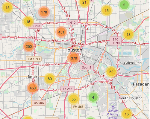
Following up on last month’s Supreme Court decision highlighting the segregation effects of Texas’s low-income housing programs, Chronicle reporter Jayme Fraser has a few observations about how the Housing Tax Credit program has been administered around here — after studying the above map, which she assembled to show the location and details of every Houston-area property involved in the program from its start in 1987 through 2013. Using federal funds, the Texas Dept. of Housing and Community Affairs offers tax incentives to private apartment developers in exchange for guarantees to keep rents on new or rehabbed complexes below the market rate.
***
Her conclusions: “The projects cluster in the same areas decade after decade. Northside. Alief. Sunnyside. Developers might have chosen the areas because of high need in the neighborhood, cheap land or little effective community opposition.” And: “Some neighborhoods are notably empty. Pearland. West University Place. Pretty much every neighborhood west of downtown between I-10 and U.S. 59.”
- Map: Did Texas tax credits reinforce segregation? [Houston Chronicle]
“Some neighborhoods are notably empty. Pearland. West University Place. Pretty much every neighborhood west of downtown between I-10 and U.S. 59.â€
Also notice the ship channel corridor is empty just like west of downtown… But that truth doesn’t support the angle of the article. The map tells me the tax credit projects are spread evenly across the region.
well, there is a good reason for west u, bellaire and southside place to be empty. they are not in houston, they are their own cities as is pearland and make their choices as to what is best for their citizens not people in houston.
the first three i listed have very little multifamily housing to start with. besides, those areas are nice. why would you want to sully the area with a bunch of low income folks? it is no mere coincidence that those same dots on the map also tie to areas with high crime rates.
and when you answer, make sure to leave the neighborhood where you live so we can look at locating those “poor” people next to your house. you know, so it is fair…
“Also notice the ship channel corridor is empty just like west of downtown… But that truth doesn’t support the angle of the article. The map tells me the tax credit projects are spread evenly across the region.”
Also notice that the ship channel corridor is mostly comprised of industrial and commercial zones with relatively few people living there, while the west of downtown is a huge residential area. But that truth doesn’t support the angle of your comment.
http://www.city-data.com/city/Houston-Texas.html#mapOSM?mapOSM%5Bzl%5D=11&mapOSM%5Bc1%5D=29.735166213212125&mapOSM%5Bc2%5D=-95.26451110839844&mapOSM%5Bs%5D=blocks3&mapOSM%5Bfs%5D=false
@kjb
That area is mostly industrial- there’s not much housing of any sort. So the lack of tax credit apartments there means little.
@kjb434 – I understand your point but there is a big difference between Clinton drive between Sam H and 610 on the east side and Memorial park area.
Don’t question The Narrative, kjb.
Yep, the Chronicle author’s typical “down with the white oppressor for keeping housing projects out of their neighborhoods” logic fails when you just look at the map and see them peppered all over Katy, Cypress, and The Woodlands. I guess the people there just didn’t have enough money or political clout. (Side note: the apartments off Sawmill in The Woodlands are locally known mostly for intermittent stabbing and shooting incidents.)
Also, according to this map, Allen Parkway Village is “elderly only”. Not from what I see walking or biking by there!
Nothing in the So. Main area. Maybe apartments there are cheap enough already.
In many of the areas where tax credit projects have been built, they represent a significant upgrade in both physical and management terms from the apartments that had been there before.
.
To the commenter who noted that West U and Pearland aren’t the City of Houston – yes, but this is a federal program administered at the state level. City limits have little to do with it except for land use zoning differences, which apply to any kind of multifamily, not just tax credit projects.
.
The new Supreme Court ruling likely means that you’ll be seeing more new map dots in outer middle class suburbs than you did in the past, as most of the traditional low income inner / middle ring suburbs where these project more typically were built will now fall under the “disparate impact” finding.
Maybe developers put them there because that’s were tax credit projects are financially feasible given average market rents with 20% of them at the program-adjusted rents, and maybe the projects aren’t financially feasible in areas with significantly higher land costs that will require projects of much greater density, and therefore cost?
Nothing in Fondren Southwest? This map surely can’t be the entire population, right?
I totally agree with the Fondren and bellair area !!! There are so many seniors that are in need of the use of tax credit property’s !!! I’ve called at least 9 different properties that are totally full with a waiting list up to about 3 year wait! Now u explain to me if this is the case there is definitely a need for a lot of us citizens u know we need homes to live into also Medicare SSI citizens don’t make enough to live any where else when it on a 761.00$ a month I sure would like to hear some answers to these questions? That’s why we have so many homeless people not that we’re lazy it’s because can’t afford any other property or we’re have a disability 😫 Thank You very much
Also if u make 761.00$ a month the u can only qualify for a 350.00$ a month apart ! Every where u go u have to make 3 TIMES the amount of ur rent !! That doesn’t exist no where so I tell me where do people like that go ? Under a bridge? Thank You