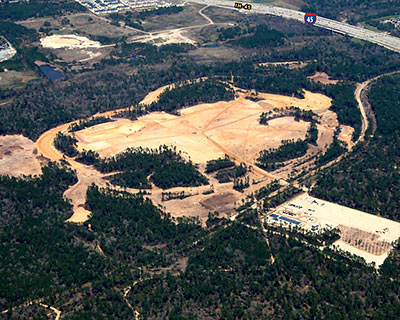
What’s been going on deep in this pine forest north of Houston, behind the fencing and security guards, where all those trucks have been driving in and out for months? A whole lot of logging at least, it looks like. While ExxonMobil continues to tell its employees that no decisions have yet been made about whether to consolidate approximately 17,000 of them from Houston and Virginia into a new 3 million sq. ft. office campus just south of The Woodlands, contractors working for the company have been stripping what looks like thousands of trees from its 359-acre property and preparing the site for construction of as many as 2 dozen office buildings, 4 enormous parking garages, and several other structures. These aerial photos of the site sent to Swamplot are dated March 12th.
***
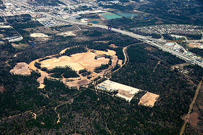
Plenty of trees have been left to stand guard around the high-security future North American headquarters of the U.S.’s largest oil company. These views are from the southwest. The freeway running from the top left to the right of the above image is I-45; the Hardy Toll Road branches off and heads toward Downtown just opposite where a new road, Springwoods Village Parkway, connects the campus to the freeway feeder road. The small clearing to the south of that connection, at the far right of this photo but on the near side of the freeway, marks the location of one of the few establishments operating in the immediate area: the former D.B. Cooper’s Mansion strip club.
The much larger rectangular clearing to the south of the future campus and Springwoods Village Parkway shows up in earlier aerial views of the property. That land may serve as a construction staging area, but the site itself is slated to become an “Uptown Residential/Mixed Use” portion of the enormous 1,800-acre Springwoods Village development planned for the forested areas surrounding ExxonMobil’s new campus to the south and west.
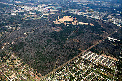
Directly to the south of the Springwoods Village land lies the proposed path of the 180-mile-long Grand Parkway, the next giant ring road getting ready to loop its way around Houston. If Swamplot can get more good tips from readers, we’ll publish more on plans for that new highway — and Exxon’s role in making it happen.
- Previously on Swamplot: A First Look at the Plans for ExxonMobil’s Humongous New Corporate Campus North of Houston, How Springwoods Village Will Earn Its Lunch Money, and other Secrets of the Great ExxonMobil Frontiers, Who’s Behind Springwoods Village, Anyway?, Is Springwoods Village the New Exxon Mobil Eco-City?, Spawn of the Grand Parkway: Huge New Woodlands-Like Development, Just South of The Woodlands
Photos: Swamplot inbox



Is that chunk of the Grand Parkway going to be where, I assume, what looks like some sort of utility easement runs between the two neighborhoods?
Where did you obtain these photos?
Yes, I’m interested to know where the photos came from, too! ;p
As for the utility easement, it is also where the railroad tracks run through. I’m pretty sure the GP will run right along it.
The photos are from a drone shot down shortly after these photos were transmitted.
Very funny. I was also wondering about that too. It seems that Exxon has attempted to be secret about this and yet it is obviously happening. Was wondering if Houston Business Journal or some other media company paid for the aerials…
The photos are at least attempting to be “official” with the highway labelings. It seems as if these could have been leaked official photos :o
One possibility is that the contractor had the aerials taken and that a swamplot mole has infiltrated the contractor’s inner circle.
I think the Strip Club had them taken
Might have been some TXDOT aerial photos for the sloooow work they’re doing on the Grand Parkway.
…might have been two dudes in a Cessna who
filed a flight plan!
The photos were sent to Swamplot. We don’t know their original source.
Poppycock! These are obviously crop circles and evidence nothing more than an imminent alien invasion.
The strip club was shut down either earlier this year or late last year after being there for years. I didn’t think anything of it (other than a bureaucrat getting looking for a promotion). In hindsight, it’s rather convenient for the developers that their family oriented development doesn’t have a strip club right next door. Think it helped with funding to have the club gone?
I disagree – nothing says Oil & Gas like a trip to the titty bar buffet for a lunch and libations. So maybe this is a new mega-church?
@patrick: You’re right, D.B. Cooper’s Mansion closed in 2009, though its website lives on. The Houston Press ran a story on the closing at the time. We’ve corrected the text.
It’s amazing to me that something this size has remained beneath the radar of the local media.
ME have been hiding in a tree and me have seen snakes, spiders and skunks and turkeys… me not sure but me think that the skunk smells really bad like when I pull down my sweat pants in the PORTO POTTIE.
Turkeys go GOBBLE GOBBLE GOBBLE
I tooted in my eye :(
I had a deer stand in one of those trees.
me saw you Bill…. them bumblebees will sting your eyes next time
FYI…this will not be Exxon’s “future North American Headquarters”; that will continue to be located in Irving. This is just a consolidation of the Houston opertation, as well as relocating the former “Mobil” employees (when Exxon purchased Mobil in 1999, they agreed to leave those employees in Virginia for at least 10 years).
Anyone know when the construction will be completed?
On may in to work this morning, driving south on 45 and going over the Rayford/Sawdust bridge, I could clearly see a crane poking out above the trees in the Exxon campus area.
Hopefully the deforestation did not transpire in the Spring, with trees full of baby squirrels, birds, etc. That’s just wrong.
Baby squirrels? Birds? Meh
As of weds 4/20, there are two tower cranes and two more boom cranes (erecting other tower cranes?) working on the property, visible to the SW from 45 between Rayford/Sawdust and the Hardy
I believe the Grand Parkway will cross the freeway right where that patch/forest is located just on the other side of 45 in that last pic.
NOT EVERYONE WILL BE CONSOLIDATED TO THAT LOCATION. SOME OF US HAVE BEEN LAYED OFF AND REPLACED BY CONTRACT WORKERS. WHO CARES ABOUT QUALITY WORK ANYMORE. ITS ALL ABOUT THE MONEY.
Who is the general contractor
FEMA camp in disguise,plus there is a HAARP-like antannae array close by (camoflauged).I live in spring and we have been close to the site. We need Jesse Ventura to investigate…
I’m still a bit heartbroken that one of my old, favorite, corny Houston jokes will go away……
Q: “How does the president of Exxon summon his limousine?”
A: “He goes to the corner of Milam, and Pease…”
Anyone have any good leads for any admin jobs for this new location in The Woodlands(other than the normal)?
Just lookin
You would have to apply on the EM website or apply with a temp agency. Good luck. I can give up my admin postion in 9 years :) I myself will have to make the move from an Greenspoint office to the new campus. Im sure its going to be really nice.
Also I did hear that supposebly a new aerial shot of this was now on Google. I havent looked myself.
None of the comments I read mentioned the trees downed for this complex which could have been built on dead land somewhere and tress planted instead of logged.
We stupid humans are killing our own air supply, ground waters etc.
The drought killed additional trees & there still is a drought so perhaps the Woodlands is going to go up in flame, fueled in part by Exxon’s shortsighted greed.
Another scab on the Earth; A scab with an invisible wound that will fester underneath and leak toxins into the water, add pollution to the air, add heat from the loss of trees and addition of hardscape. Tragic and unnecessary.
Moriah, there is no imaginable way this project could cause a forest fire short of a fire on site spreading to the forest.
Dave – I agree, this has the stench of a FEMA Dentention Camp. Some guys i meet at a bar have been going on the property at night to take photo’s of the buildings with the 15 ft + chain link fence that have in-ward facing razor wire. This compound is just 100 yards to the south of the main construction site. But, they have been chased by heavliy armed guards. Also, the google satelite photos are over a year old and are not being updated.
See the following GPS cordinates:
Possible Detention Camp Main Construction Site
30.103336,-95.446596
Possible Detention Processing Center
30.097111,-95.447252
Also, the one and only entrance on I-45 is way to small and constricted by 2 lights, outbound traffic will have to cross over I-45 and then turn north only to exit the property. Currently only one way to enter is at this same light on the service road, very secure for a high security facility, but not driver accessible for a commercial property.
Also, the snake infested creek that borders the property to the north has recently been declared a “Nature Preserve” but the access to this says “No Trespassing” and warnings that say area under “Camera Survelliance”.
And, i have extensive background in Construction Management, but the Gilbane-Harvey employment and training center is by appointment only and they refused to allow me to apply after taking my information and a request for a application form. This facility is one mile to the north on the same I-45 service road, just before the spring creek and main entrance.
It also has chain link fence around it and camera’s.