COMMENT OF THE DAY: A HISTORICAL METHOD OF EXPANDING HOUSTON’S FLOODPLAINS 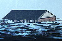 “Another recent policy development is that subsidence is now taken very seriously (with massive infrastructure being built to put utility districts onto surface water from Lake Houston and the Trinity River). But it was a very, very big problem up until around 1990. So you had all this sprawling development inside of Beltway 8, and off of 1960, and out near West Oaks, and there wasn’t adequate on-site or off-site stormwater retention infrastructure that had been built — and that same development thereafter was sinking at a steady rate, so that any flood control infrastructure was becoming increasingly obsolescent for reasons other than simply rainfall rates and runoff.” [The Niche, commenting on Comment of the Day: Who Foots the Bill for Houston Floods] Illustration: Lulu
Sign up for the Newsletter
Tag: Subsidence

COMMENT OF THE DAY: THAT SINKING FEELING  “At 13 seconds in, those houses across the water at the top of the frame are at the end of my street, South Burnett Drive, in the Lakewood subdivision. The street rises gradually as you travel away from the water, but the low end of the street lost over 20 houses during Hurricane Ike. Some owners have rebuilt on pilings, some have rebuilt at grade, and others have abandoned the property. (My own house is further up the street, at about 31 feet elevation.) The end of the flood debris field from Ike was about three lots south of my house. So, while the name ‘Swamplot’ is amusing, to some of us it is no joke.” [Reeseman, commenting on Flying High Over the Baytown Subdivision That Sunk] Illustration: Lulu

Here’s some raw footage from a camera-wielding drone flight landscape artist and researcher Steve Rowell piloted earlier this year over portions of the Baytown Nature Center, the Crystal, Scott, and Burnet Bay peninsula that not too long ago was the home of the tony Brownwood subdivision — before it got all sinky and decided to subside 10 or so feet into the water. In some portions of the video, you can still spot the occasional home or garage slab from a fifties- or sixties-era rancher or 2, not to mention concrete broken up from other foundations and driveways and recycled on-site into surge barriers that now control the more recent, court-ordered wetlands environment.
Touring Brownwood by Drone


Parts of Jersey Village have been subsiding by about 2 inches a year, according to 2 UH professors and a former grad student who’ve been studying a decade’s worth of GPS data from 2 dozen area measurement points. Associate professor of geology Shuhab Khan, geology professor Kevin Burke, and former Ph.D. student Richard Engelkemeir note there’s been gradual subsidence in a “sprawling” 324-square-mile area of northwestern Harris County, but Jersey Village is the fastest to fall.
Just what is it that makes this little community so down-to-earth? Reports Khan:
The most likely reason for the sinking of Jersey Village is the withdrawal of water from deep beneath the surface. While groundwater withdrawal has ceased in most of the Houston area, it continues in the northwestern part of the county that has seen a rapid growth in population.
Continued subsidence, of course, will also help the entire northwest Houston area collect more water when it rains. But it isn’t all downhill for Houston.
